|
|

|
|||
|
Zion National Park Lodging Zion Info Vacation Weather Photos Hike Slot Canyons Backpack Camping |
||||

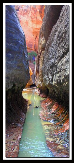
The Subway in Zion National Park
|
|||||||||||||||||||||||||||||||||

 Shuttle Setup - Drive to Virgin, which is 26-miles northeast of St. George on SR-9. Toward the end of town, turn onto the Kolob Reservoir Road and head north for 8 miles. Park your vehicle at the Left Fork Trailend, the bottom end of the Subway, then continue 8-miles north to the Wildcat Canyon Trailhead to park another vehicle and begin the route.
Directions to Zion National ParkFrom the North: Travel I-15 south, past Beaver. exit on Hwy 20. Follow US-89 to Mount Carmel Junction. Take SR-9 to Zion's east entrance.
|
|
|||
|
|
||||


Russell Gulch - Once at the bottom of the gulch, hike to the slickrock on the east side of Russell Gulch. Look for cross-bedded dome-like hoodoos, high in the saddle, to the south. Continue over the slickrock, traversing toward the domes, passing between the domes at the saddle. Hike to the south, down the large slickrock bowl, surveying the landscape for the trail entering into the vegetated area at the end of the bowl. Continue a short distance where the beaten path arrives at a small wash and lures hikers to the right, but keep an eye out for a cairn to the left, that once again ascends to another small saddle and then descends into another wash. The trail then ascends a short distance and traverses for a couple hundred yards before the steep, final descent into Russell Gulch. Watch for the pine tree next to a slab of rock on the right. This seems like an improbable chute to maneuver, however, by carefully stepping down the "rock and root stairway and picking through the loose rock for 300 vertical feet, the bottom of Russell Gulch is obtained. At the bottom of this steep chute, turn left, and walk 100 yards to find the confluence of Left Fork of North Creek and Russell Gulch. Turn right at this confluence.
Boulder Obstacle - Walking down the left Fork of North Creek for about 300 yards the first obstacle appears. Scamper up the boulder and locate the sling anchor on the right side of the 12' rock. Secure a doubled rope so the last person in the party can pull it free. This is an easy and straightforward rappel. There is a chimney on the right side of the boulder which can also be rappelled. Do not jump! Search and rescue teams are often called to the Subway for those that are unprepared to navigate obstacles and thus get hurt jumping. Some people have slid down the log wedged in the slot at the first drop but is not recommended
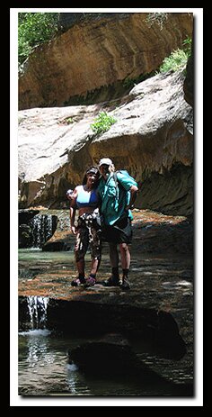
Time to Get Wet - Be prepared to pack cameras and other sensitive items into dry bags if you have not already done this. If the temperatures are cool outside, wetsuits are required for the next section. The water in the canyon is ice-cold, even in the middle of the summer, but in spring and fall it can be dangerously cold. Even when it is hot outside, it's best to wear quick dry clothing and keep other clothing dry to put on in the shady and cool Subway section. Navigate through or around the potholes. Never jump into a pothole! Also note that each flash flood changes the character of the route and the depth of the pools.
Canyon Route - Continue down canyon and prepare to swim. The first pool can be 30-feetlong, followed by a shorter pool. At the end of the first pool there is a submerged window that some choose to swim through.
Second Obstacle - Bolts in the now narrow slot canyon may have a webbing sling attached that aids in the 8' drop to a small ledge and then another 3-4' drop into this pool below.
Caution - Do not jump into the pool, a submerged rock just 3' below the surface could be dangerous. This is a difficult obstacle for many to navigate without some aid. Swimming is required after climbing into the next pool of water. The next two chambers are wonderful photo opportunities, but keep your camera safe and dry by using two good quality dry bags, one inside the other.
Keyhole Falls - Yet another waterfall in the narrow slot will necessitate the use of a rope. The drop is only 8' to the water, but, once again, submerged rocks make jumping dangerous. To the right, an old bolt with a hanger is used as an anchor that allows a hand line or rappel through the crack. The first drop is about 20' but a longer rope is needed because the anchor is set back.
The Subway - The quarter-mile passage through the Subway is the most charming segment of the adventure. Deep inside the tubular tunnel glimmers of sunlight trickle into the darkness, allowing algae to grow in the water filled potholes. The green flora creates an eerie turquoise glow that radiates throughout the spectacular chamber. Finally, the crystal clear water splashing through this picturesque setting meanders over polished rock to the open canyon below.
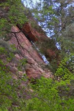
Log Chamber and Subway Arch - Inside the Subway, just past Keyhole Falls is a chamber where there may be a log perched against the wall. It is amazing how long it has stayed without a flood washing it away. Ten yards before arriving at the leaning log, look up and on the left to the silhouetted cliff above where you can spot the free-standing arch.
Final Obstacle - A few yards past the leaning log, staying to the right, walk the rock ledge to bypass the 6' waterfall in the watercourse. Continue downstream 50 yards, where the canyon turns to the left and arrives at the final obstacle. A log jammed between a narrow crack in the rock waterway becomes a short bridge over the waterfall to cross onto the slickrock ledge on the left. Walk downstream on the ledge 20 yards and locate a two-bolt anchor, just 6 feet below inside a small bowl.) A 60' rope is suggested to safely navigate this obstacle. This 30' obstacle is a difficult rappel if the rock is wet and slippery from moss. The rock becomes vertical near the bottom so the best climber should rappel down first to help the others in the party.
Waterfall Room - Once at the bottom of the final obstacle, be sure to wade, swim and work through the potholes back upstream to see the Waterfall Room. This is the waterfall you walked over by using the wedged log bridge . Stay and enjoy the many desert tanks in the once again Tunneled Subway. Those who choose to hike up from the bottom will turn around at the waterfall room and exit the same way approached.
Cascades - Shortly after leaving the Subway there are several notable cascades. Use caution since the falls are slippery. Enjoy the beautiful cascades and crystalline water. The route from the last cascade now crosses back and forth from one side of the creek to the other and occasionally travels in the center of the watercourse.
Dinosaur Tracks - 7 miles into the trip, on the right, north, are two large slabs of white rock angled toward toward the river with embedded prints made by an ancient type of dinosaur therapod known as the Grallator.
Locating the Exit - It's easy to miss this exit, so be aware/ The exit from the Left Fork of North Creek is downstream from the dinosaur tracks and although there is often a small sign, this indicator can be washed away. Look for the large sandstone cliffs on the right and if you see basalt cliffs instead you have gone too far.
Hike Out - The exit scrambles up to the top of the basalt ridge that appears in front of you. It will seem impossible to climb, but the steep route ascends up and to the right of the 100-200' high basalt cliffs.
Caution - The Subway is a technical slot canyon that has become popular due to the many images in the media, but its a difficult adventure. Take the canyons in Zion serious and go prepared. Down climbs and short rappels are required. Bring a rope and gear. After the fun, there is a hot steep trek out of the creek.
Hiking The Subway from the BottomBegin at the described Subway trailend, located 8 miles north of Virgin on the Kolob Terrace Road. Locate the dirt path and hike a half mile through a juniper and pinion forest before descending almost another half mile down the steep trail to arrive at the Left Fork of North Creek. Follow the trail upstream as it skirts and crosses the creek numerous times. After about a mile of hiking along the creek watch for the dinosaur tracks. After 3 miles of creek hiking there will be wonderful wide slabs of stair stepped sandstone covered with glistening cascades of water. Be very careful traveling on these slabs as they are very often slippery. After several scrambles through and around these pristine cascades, the trail arrives at the Subway. Traveling beyond this point becomes extremely difficult, however be sure to wade and swim through the narrow corridor and visit the Waterfall Room at trails end. Total distance to this point has been close to 5 miles.
Subway GPS Coordinates - WGS84 Datum
| Parking at Wildcat Canyon Trailhead: Elevation 6985' 37°20.4490N 113°04.5539W |
Entry Trail To Left Fork: 37°19.1274N 113°02.4163W |
||
| Junction Of Wildcat Canyon Trail and Northgate Peaks Trail: 37°20.3994N 113°03.5507W |
Wildcat Canyon Trailhead: 37°20.455 N 113°04.564 W |
||
| Trail To Russell Gulch: 37°20.2877N 113°03.4502W |
Dinosaur Tracks: 37°17.986 N 113°04.207 W |
||
| Cross Russell Gulch to the East Side: 37°19.8492N 113°02.6792W |
Exit from Left Fork: Elevation at Bottom 4700' Elevation at Trailend 5100' 37°17.378 N 113°05.084 W |
||
| Slickrock Saddle: 37°19.6445N 113°02.5941W |
Parking at Trailend: 37 17.080 N 113 05.761 W |
GPS coordinates are only references and may or may not be accurate. Do not rely on GPS coordinates as the sole method of navigation. Always have an accurate, detailed map at hand and have the proper map reading and navigation skills before setting out on any hike. Many of the hikes listed in this guide travel into canyons where a GPS has limited capabilities. Always check your position with a detailed map before dropping into a canyon.
Kolob Terrace Options
Das Boot
Das Boot is an technical option for entering The Subway or it can be done on its own.
This is on the Sierra Clubs list of the top one-hundred desert peaks to do. This trail is outside of the main section of Zion National Park and in the Kolob Terrace section along with The Subway and Das Boot.
Freestanding Arches in Zion
Beta: Coordinates and other trail and canyoneering information by Zion Park search and rescue veteran team member Bo Beck and zionnational-park.com author Mary Cisneros.
Corrections: To post trip reports, offer corrections, updates, or for more information please visit the
Zion National Park Forum
Suggested Equipment: A sturdy pair of shoes are recommend to hike a long distance in the Subway. Many quality shoes will help grip the rocks and prevent injury. Experienced hikers and Canyoneers often prefer a good quality rubber shoe like Sportiva Exum Ridge. Other prefer the Aqua Stealth Rubber Shoes or 5-10 Canyoneers but these are not as good for hiking. You might want to try wearing neoprene socks with them for added comfort if they are not already part of the shoe. Canyoneering Rope is required for this semi-technical canyon.
Zion National Park Menu
|
|
Zion National Park, Utah
History of the Thunderbird

East Zion Lodge
Vacation House
Group Lodging
East Zion Golf
East Zion RV Park
Vacation Packages
Family Reunion
Bus Tours
Business Retreat
Mileage from
Mt. Carmel Jct.
Zion National Park 12
Bryce Canyon 60
Grand Canyon 85
Cedar Breaks 45
Grand Staircase 9
Dixie Forest 22
Sand Dunes 11
Coyote Butte 57
Red Canyon 47
Tuweep 90
Stay in the heart of the parks, Mount Carmel Junction, and visit the treasures of the Southwest and Utah.
Site Map
Site Map II
Site Map III
Zion Hiking
Zion Park Hiking
Zion Hiking Adv.
Zion Canyoneering
Kolob Hiking
Greater Zion Area
"I don't know who Mary Cisneros is, but I mean zionnational-park.com
It's a better site than the NPS's anyway."
Written by the authors of the book: Favorite Hikes in and around Zion National Park
|
Zion History |
|---|
All rights reserved © Copyright Zion National-Park dot com
Do not use text, photos or maps without permission © Zion National-Park dot com
Contact the Author Mary Cisneros with any errors