|
|

|
|||
|
Zion National Park Lodging Zion Info Vacation Weather Photos Hike Slot Canyons Backpack Camping |
||||

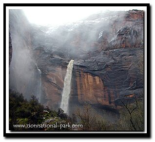
Weeping Rock
|
||||||||||||||
 Where does the "weeping" come from?
Directions to Zion National ParkFrom the North: Travel I-15 south, past Beaver. exit on Hwy 20. Follow US-89 to Mount Carmel Junction. Take SR-9 to Zion's east entrance.
|
|
|||
|
|
||||


View from Weeping Rock 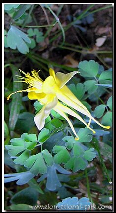
The view from the alcove is both unique and pleasing with Observation Point, Lady Mountain, Great White Throne and the Organ being its central focus. This is a great trail for families. A nice extra on this hike is the trailside exhibits, offering the names of flora found along the path such as the horsetails. There is a nice view of the Weeping Rock alcove from above that can be seen when hiking the Hidden Canyon or Observation Point trails.
Hanging Gardens and Columbines
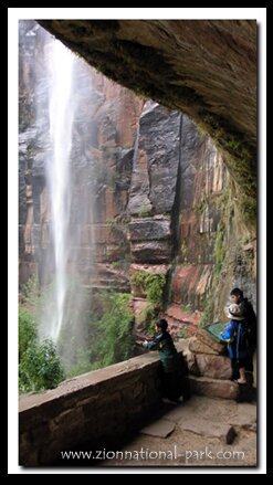
The alcove: Weeping Rock This trail is a half-mile round-trip which is the shortest trail in the park, but the broken pavement and moderately steep climb make it unsuitable for wheelchairs and strollers. To begin walk the footpath crossing over a drainage stream that is lined with cottonwood, ash and maple trees. The trail is well traveled due to its beauty, location and short length. At the top be prepared for slippery moss on the rocks and walkway as well as water dripping on the path. Steps culminate at a large eroded carved out area, something like a sponge soaking up water then releasing it slowly to feed the hanging gardens and dripping excess into the water hole below. When I met my hiking partner, Bo Beck, I told him I was going to hike every "trail" in Zion. I had no clue what that actually meant until we began to explore. With everything I have seen over the many years I still am partial to this little corner of the park that I visited so many times as a child.
Weeping Rock at a Glance
Day Hike: Yes
Distance: .5 miles
Average Hiking Time: 1 hour-round-trip
Difficulty: Easy and short trail, but it is steep.
Permits: Not required.
Trail Conditions: This is a well-maintained trail, but incline and broken pavement in places makes it tough for strollers and wheelchairs. The steep incline of the path would also make it difficult to push a stroller or wheelchair. This is a cooler hike even in the hottest parts of the day. Water seeps down from above the Weeping Rock alcove onto metal steps and it does get slippery. Be prepared to get a little wet.
Trailhead: Begin at the Weeping Rock parking lot, then cross the stream on the footbridge. The trailhead breaks off to the left, opposite Hidden Canyon, East Rim and Observation Point Trailheads.
Trailend: Same as trailhead.
Trail Access: When the shuttles are running, which is usually mid-March to mid- November, park at the Zion Canyon Visitor Center and ride the Zion Canyon Shuttle. Get off at the Weeping Rock shuttle stop. The rest of the year, when the shuttles are not operating, drive into the canyon and park at the Weeping Rock parking lot.
Off the Beaten Path: No, this is one of the two most traveled trails the park. Stay on the trail as tempting as it is to wander off the path and down into the pool of water beneath the trail. Straying from the trail damages the delicate desert environment and sandstone is slippery so never walk or stand at the edge of a cliff.
Classic Zion Hike: Yes 
Best Season: March to October. This trail might be closed for short periods in winter during icy conditions and shady areas that get little or no sun. Ice sickles might also form in the alcove forcing its closure. In the summer expect a gentle wall of water to trickle from the rocks, but in the winter there is often a flood of water pouring from above.
Elevation gain: 98 feet
Restrooms: Vault toilet at the trailhead.
View from Weeping Rock
The view from the alcove is both unique and pleasing with Observation Point, Lady Mountain, Great White Throne and the Organ being its central focus. This is a great trail for families. A nice extra on this hike is the trailside exhibits, offering the names of flora found along the path such as the horsetails. There is a nice view of the Weeping Rock alcove from above that can be seen when hiking the Hidden Canyon or Observation Point trails.
Hanging Gardens and Columbines
The alcove at the end of the trail is fun and kids enjoy getting wet while adults delight in the lush hanging gardens. Weeping Rock is home to one of the most complex of hanging gardens. The hanging Columbine found under the alcove is endemic to Zion. Look near the steps where it is very wet and there is a nice selection of Columbines there on the ground. There are two species of Columbine in the park: the golden columbine, which is the one with the yellow flower and the western columbine which has red and yellow flowers.
Cable Mountain
What I like about this delightful trail begins in the parking lot where the Great White Throne towers above the area where the shuttle stops. The enormous Cable Mountain can also be seen from the trailhead. There is a interpretive sign telling the history of this mountain. The Cable Mountain Draw Works was used from 1901 until 1927 to carry timber and men from the top of Cable Mountain down to the Zion Canyon – Zion Lodge area. In the winter of 2011, a project by the park and the University of New Mexico School of Planning and Architecture to stabilize the historic structure was completed. The end of the trail is fun and kids enjoy getting wet while adults delight in the lush hanging gardens. Weeping Rock is home to one of the most complex of hanging gardens. The hanging Columbine found under the alcove is endemic to Zion. Look near the steps where it is very wet and there is a nice selection of Columbines there on the ground. There are two species of Columbine in the park: the golden columbine, which is the one with the yellow flower and the western columbine which has red and yellow flowers.
Cable Mountain
What I like about this delightful trail begins in the parking lot where the Great White Throne towers above the area where the shuttle stops. The enormous Cable Mountain can also be seen from the trailhead. There is a interpretive sign telling the history of this mountain. The Cable Mountain Draw Works was used from 1901 until 1927 to carry timber and men from the top of Cable Mountain down to the Zion Canyon – Zion Lodge area. In the winter of 2011, a project by the park and the University of New Mexico School of Planning and Architecture to stabilize the historic structure was completed.
Beta: Coordinates and other trail and canyoneering information by Zion Park search and rescue veteran team member Bo Beck and zionnational-park.com author Mary Cisneros.
To post trip reports, offer corrections, updates, or for more information please visit the Zion National Park Forum
Suggested Gear: A sturdy pair of shoes are recommend to hike the trails in Zion National Park. Many quality shoes will help grip the rocks and prevent injury.
|
|
Zion National Park, Utah
History of the Thunderbird

East Zion Lodge
Vacation House
Group Lodging
East Zion Golf
East Zion RV Park
Vacation Packages
Family Reunion
Bus Tours
Business Retreat
Mileage from
Mt. Carmel Jct.
Zion National Park 12
Bryce Canyon 60
Grand Canyon 85
Cedar Breaks 45
Grand Staircase 9
Dixie Forest 22
Sand Dunes 11
Coyote Butte 57
Red Canyon 47
Tuweep 90
Stay in the heart of the parks, Mount Carmel Junction, and visit the treasures of the Southwest and Utah.
Site Map
Site Map II
Site Map III
Zion Hiking
Zion Park Hiking
Zion Hiking Adv.
Zion Canyoneering
Kolob Hiking
Greater Zion Area
|
|
"I don't know who Mary Cisneros is, but I mean zionnational-park.com
It's a better site than the NPS's anyway."
Written by the authors of the book: Favorite Hikes in and around Zion National Park
|
Zion History |
|---|
All rights reserved © Copyright Zion National-Park dot com
Do not use text, photos or maps without permission © Zion National-Park dot com
Contact the Author Mary Cisneros with any errors