|
|

|
|||
|
Zion National Park Lodging Park Info Vacation Weather Photos Hike SR-9 Slots Backpack Camping |
||||

Left Fork of North CreekThe Subway from the BottomThis is an option for those hikers that don't want to swim and down climb difficult obstacles, yet want to be able see some of the amazing treasures found in the infamous "Subway" hike. A permit is still required to hike bottom-up and can be acquired via the online permit system or by visiting the permit office at the visitor center in the main canyon. Information 1-435-772-0170. For directions to hike the Subway from the top, follow the following directions instead: The Subway
Dinosaur Tracks - After about 1 mile of hiking along the creek keep an eye out for 2 large slabs of white rock sloping toward the creek just above the bank on the left. The rocks are about 50' wide and 15' tall and contain many dinosaur imprints imbedded in them.
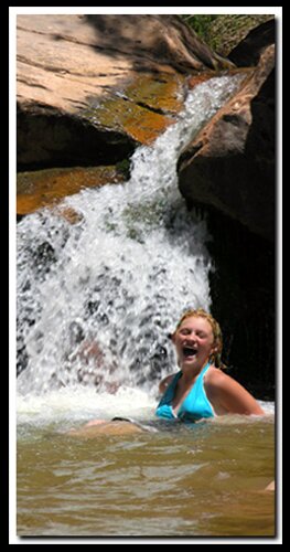
The Subway - After several scrambles through and around these pristine cascades, the trail arrives at one of the most beautiful sections of the hike. Potholes filled with emerald waters, delicate ferns and desert shrubbery cling to the moist, tubular shaped sandstone walls surrounding this desert paradise. Travel beyond this point becomes extremely difficult, however be sure to wade and swim through the narrow corridor and visit the waterfall room at trails end! Total distance to this point has been close to 5 miles. (Some travelers may wish to attempt up climbing beyond this point, but this can be extremely difficult and dangerous; not recommended.) Relax, take many pictures, have some lunch and prepare for the return trip.
Trailhead - Trailend Exit from Left Fork: GPS coordinates are only references and may or may not be accurate. Do not rely on GPS coordinates as the sole method of navigation. Always have an accurate, detailed map at hand and have the proper map reading and navigation skills before setting out on any hike. Many of the hikes listed in this guide travel into canyons where a GPS has limited capabilities. Always check your position with a detailed map before dropping into a canyon. Freestanding Arches in Zion National Park
To post trip reports, offer corrections, updates, or for more information please visit the Zion National Park Forum Suggested Gear: A sturdy pair of shoes are recommend to hike the trails in Zion National Park. Many quality shoes will help grip the rocks and prevent injury.
Zion National Park, UtahHistory of the Thunderbird |
East Zion Lodge Mileage from Stay in a hotel the heart of the parks, Mount Carmel Junction, and visit the treasures of the Southwest and Utah. Site Map Zion Hiking More Kolob Hiking |
||||||||||||
|
This is my new favorite quote:
"I don't know who Mary Cisneros is, but I mean zionnational-park.com It's a better site than the NPS's anyway." Written by the authors of the book: Favorite Hikes in and around Zion National Park |
|||||||||||||


 GPS Coordinates WGS84 Datum
|
Zion History |
|---|
All rights reserved © Copyright Zion National-Park dot com
Do not use text, photos or maps without permission © Zion National-Park dot com
Contact the Author Mary Cisneros with any errors