|
|
 |
|||
|
Zion National Park Lodging Zion Info Vacation Weather Photos Hike Slot Canyons Backpack Camping |
||||

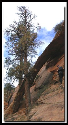
Two Pine Arch and Progeny PeakOn the east side of Zion National Park, detailed patterns have been wind swept into blond slickrock and imbedded with subtle tints of yellow, pink and green. A wonderland of geological processes twisted and tortured the rock and sand into magnificent arrangements of stone. Uplift and erosion resulted in spires, domes, hoodoos, mountains and an occasional arch. A few arches stand today in the arid landscape of the park. Although arches are common in other areas of southern Utah, there is no place that surrounds them with such sweet scenery as does Zion. Two Pines Arch is such a treasure. Climb Progeny Peak above the arch and panoramic majesty unfolds in every direction.
 Starting Elevation: 5200' Starting Elevation: 5200'Arch Elevation: 5600' Summit Elevation: 6275' Total Elevation Gain: 1075' Off the Beaten Path: Yes Classic Zion Hike: No Best Season: The best time of the year is spring, fall and even, but only hike on slickrock when the surface is dry. If hiking in the summer begin early in the morning to reduce sun exposure. Scrambling on slickrock should only be attempted by experienced hikers. It's important to only wear sticky hiking shoes to help grip the rock and to help avoid accidents. Slickrock is dangerous when wet and cold. The rock is often dotted with moss, which holds water and becomes slippery like ice when it's cold out.
The hike to the arch is a fairly easy one with the exception of one short section that requires scrambling. Hiking to the top of Progeny Peak offers exceptional views, but slickrock scrambling is required. The hike begins .4 mile east of the Canyon Overlook parking lot, which is located on the east side of the Zion-Mt. Carmel Tunnel. More parking is available 100 yards east of the tunnel. Yet another small area to park can be found 200 yards east of the caution sign. The trailhead is on the north side of the Zion-Mt. Carmel Highway, east of the tunnel. Look for the small wash, identified by a yellow sign that says, "Caution delays possible be prepared to stop". Cross over to the north side of the road and enter the wash on the east side, hugging the mountain, until a path of use is visible leading down into the wash. Once in the bottom of the wash, hike north for 150 yards, where the drainage splits in two. The prominent drainage veers to the northwest, and a less prominent wash goes to the right in a more northerly direction. Go right (north) and soon the wash will become more apparent. Continue hiking, staying in the watercourse. Soon a small layered dry fall is encountered. Continue up the dry fall and the wash opens up. Look to the right at the base of the cliff where "Two Pines Arch" can be seen. The arch is surrounded by Ponderosa Pine trees. At about .3 mile into the hike, the route leaves the easy terrain of the wash. Steer directly up the slickrock toward the arch. The climb is moderately steep, but it is only .1 mile. Now that you know where the arch is it will be easy to see when you return to your car. Progeny Peak From the saddle, walk easterly in the general direction of the summit and work through the ledge systems. Soon travel is easiest if you traverse slightly right and up the slabs toward the shoulder, formed on the south side of the summit. Heading too far to the north, (left) will only make the climb steeper. Some small ledges need to be negotiated on the way up to the south shoulder of Progeny Peak. Once on the south shoulder, bear to the north and it will be a short uphill scramble to the summit. Once on top , looking southwest from Progeny Peak, the end of the Zion-Mount Carmel Tunnel is visible as well as Zion's West and East Temples. To the west and north are the Twin Brothers, Mountain of the Sun, Deertrap Mountain and the East Rim. Looking east, views of Crazy Quilt Mountain and Checkerboard Mesa partially hide the white cliffs bordering the Grand Staircase. The sights are truly spectacular and worth the .8 mile hike and 1000' elevation gain.
Trailhead Two Pines Arch Progeny Peak GPS coordinates are only references and may or may not be accurate. Do not rely on GPS coordinates as the sole method of navigation. Always have an accurate, detailed map at hand and have the proper map reading and navigation skills before setting out on any hike. A GPS has limited capabilities in many areas. Zion National Park Trails with Natural Arches along the path: Free Standing Arches outside of Zion National Park Canaan Mountains Pictures
To post trip reports, offer corrections, updates, or for more information please visit the Zion National Park Forum Suggested Gear: A sturdy pair of shoes are recommend to hike the trails in Zion National Park. Many quality shoes will help grip the rocks and prevent injury.
Zion National Park, UtahHistory of the Thunderbird |
East Zion Lodge Mileage from Stay in the heart of the parks, Mount Carmel Junction, and visit the treasures of the Southwest and Utah. Site Map Zion Hiking |
||||||||||||
|
This is my new favorite quote:
"I don't know who Mary Cisneros is, but I mean zionnational-park.com It's a better site than the NPS's anyway." Written by the authors of the book: Favorite Hikes in and around Zion National Park |
|||||||||||||


 GPS Coordinates WGS84 Datum
|
Zion History |
|---|
All rights reserved © Copyright Zion National-Park dot com
Do not use text, photos or maps without permission © Zion National-Park dot com
Contact the Author Mary Cisneros with any errors