|
||||
|
Zion National Park Lodging Zion Info Vacation Weather Photos Hike Slot Canyons Backpack Camping |
||||
Zion National Park Geology
|
|||||||||||||
Directions to Zion National ParkFrom the North: Travel I-15 south, past Beaver. exit on Hwy 20. Follow US-89 to Mount Carmel Junction. Take SR-9 to Zion's east entrance.
|
|||
|
|
|||
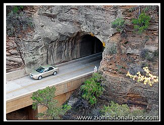
 Zion-Mt. Carmel Tunnel - The geology of Zion transforms dramatically when moving from the east section of the park through Zion's longer tunnel. The 1.1 mile-long tunnel was blasted and forged through thick Navajo sandstone during the early 1900's. Imagine cutting through 2000 foot thick sandstone with the machinery available at that time. The Zion-Mt. Carmel Tunnel was a network of scaffolding, set up on the east side of the tunnel going across Pine Creek which flows below. Blasting was used to enlarge the hole and railcars hauled off debris. On the tunnel's south side, work was not an easy task because the drop-off of the canyon below is 800 feet. It is amazing that in the 1930’s; this sort of engineering was accomplished. The whole process is considered a technological wonder and creating the Switchbacks, leading up to the tunnel, was even more difficult.
Eastside Hoodoos - The hoodoos on the east side of Zion are whimsical rock formations twisted and manipulated into various shapes and sizes. Hoodoos in the park vary far more than the uniform hoodoos of nearby Cedar Breaks National Monument and Bryce Canyon National Park.
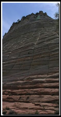
 Checkerboard Mesa Geology - Deep furrows in the shape of a checkerboard game, took millions of years to cut into the sandstone of Checkerboard. The horizontal furrows were made during the Jurassic period by wind-blown sands of huge ancient dunes spread out over land in place of the massive monoliths you see in Zion today. A freeze and thaw process is responsible for gradually widening the furrows along vertical joints. Notice that the carvings are always on the north side where snow takes longer to melt. The vertical slits were created much later after brittle rock had formed. There are etched patterns on smaller surfaces in the park, such as along the East Rim and Hidden Gardens. Past the east side of the park along US-89 between Kanab and Mt. Carmel Jct. evidence of crossbedding can also be found.
|
|
Zion National Park, Utah
History of the Thunderbird
East Zion Lodge
Vacation House
Group Lodging
East Zion Golf
East Zion RV Park
Vacation Packages
Family Reunion
Bus Tours
Business Retreat
Mileage from
Mt. Carmel Jct.
Zion National Park 12
Bryce Canyon 60
Grand Canyon 85
Cedar Breaks 45
Grand Staircase 9
Dixie Forest 22
Sand Dunes 11
Coyote Butte 57
Red Canyon 47
Tuweep 90
Stay in the heart of the parks, Mount Carmel Junction, and visit the treasures of the Southwest and Utah.
Site Map
Site Map II
Site Map III
Zion Hiking
Zion Park Hiking
Zion Hiking Adv.
Zion Canyoneering
Kolob Hiking
Greater Zion Area
|
Next: Zion Geology |
"I don't know who Mary Cisneros is, but I mean zionnational-park.com
It's a better site than the NPS's anyway."
Written by the authors of the book: Favorite Hikes in and around Zion National Park
|
Zion History |
|---|
All rights reserved © Copyright Zion National-Park dot com
Do not use text, photos or maps without permission © Zion National-Park dot com
Contact the Author Mary Cisneros with any errors


 Zion Will Become Sand Dunes Once Again


