|
|

|
|||
|
Zion National Park Lodging Park Info Vacation Weather Photos Hike SR-9 Slots Backpack Camping |
||||

|
||||||||||||||

 East Rim Trail - This 6 hour, 10-mile trail is spectacular. It is said to be "one of the most scenic in all of Zion National Park," and is on many lists as "one of the best hikes in Utah." With all the classic trail competition in Utah, like the
Directions to Zion National ParkFrom the North: Travel I-15 south, past Beaver. exit on Hwy 20. Follow US-89 to Mount Carmel Junction. Take SR-9 to Zion's east entrance.
|
|
|||
|
|
||||


 Jolly Gulch - Jolly Gulch is the first signed area the trail passes and is located 2.8-miles into the hike. It's a nice view down into a canyon, but when the water is flowing in Jolly Gulch the waterfall is magnificent. Layered rock is evident along much of this section of the trail.
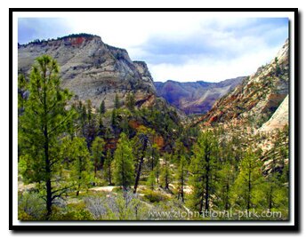
Echo Canyon - With 4.3-miles left in the hike, the East Rim Trail begins to flatten. At the top of the mesa the scenery gets impressive as the trail edges the incredible Echo Canyon slot canyon. To the west the immense Cathedral Mountain looms. The view down into Echo Canyon is incredible, with the massive West Temple straight ahead. The slickrock of East Zion is abundant here, where patterns of ancient twisted and uplifted sand dunes steal the show.
A gradual descent will now begin into what must be the most sensational section of Zion National Park. The trail is now a charming, rock lined, narrow path that winds around natures towering obstacles. The East Rim Trail shows off the incomparable magnificence of Zion National Park's geology. Crossbedded sandstone cliffs reveal themselves. Little stacks of rock (cairns) are now all that mark the trail as it meanders over wind swept slickrock slabs. Fossilized sand dunes glitter in the sun. Giant monoliths are in every direction. Scenery does not get much better than this.
East Rim and Observation Point now combine as the East Rim Trail joins with the lower portion of the Observation Point Trail. (elevation 5584 feet) Less than a half-mile is the entrance to Echo Canyon and the charming Echo Canyon Walkway.
(The hike to Observation Point from the spur, is a 2-mile, steep (strenuous) climb up and downhill hike back down the same way)
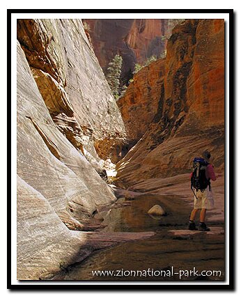
Echo Canyon Walkway and Entrance - The walkway allows for a nice close up view of Echo Canyon and leads to the entrance to Middle Echo Canyon. When conditions are dry this is a fun and easy slot canyon to explore. From the walkway, the trail descends steeply for 1.5-miles into Zion Canyon. To the right of the trail is another section of Echo Canyon where a visible water carved slot canyon winds below and during the winter and wet years there is water flowing.
East Rim, Cable Mountain, Deertrap Mountain Backpack
Backpacking option - Camp at Stave Spring. Day hike to Cable Mountain then back to the Cable Mountain/ Deertrap Mountain junction (not Stave Springs) then to Deertrap Mountain, back to Stave Springs and end at the Weeping Rock parking lot. Total mileage: 20-miles
Trail History - The East Rim Trail follows a Paiute route, the John Winder Trail, to the top of a high mesa. Winder was a Mormon rancher with a goal to link Zion Canyon to the east. in 1923, Winder led surveyors to where the Zion-Mt. Carmel Tunnel was built.
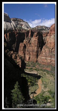
Big Bend - Farther down the trail, the panorama of Zion Canyon and Big Bend takes center stage. This panorama is one of the best views in the entire park. The Virgin River is forced around the Organ and the outline of the Angels Landing Trail is seen from its broad side. The Great White Throne and Cathedral Mountain loom in the background. The extremely steep path continues to switchback, while descending down past the spur to Hidden Canyon and finally to the Weeping Rock parking lot.
East Mesa - Drive instead of hike to Observation Point. This East Zion Trail is a shortcut to this popular Zion View Point.
Optional side hikes - A half mile past Stave Springs there is a sign directing the way to finish the East Rim Trail and giving the mileage for two options at the top of the mesa:
Cable Mountain - 6-mile round trip, with incredible views of the Great White Throne, Angels Landing, Observation Point, and the West Rim of Zion.
Deertrap Mountain - 8-mile round trip, with nice views of Mountain of the Sun, the Twin Brothers and the Court of the Patriarchs.
Hidden Canyon - This trail is located toward the end of the East Rim/Observation Point trail. From the canyon entrance its .5-miles to the 20 foot freestanding arch and then it is possible to continue about .6 more miles through the canyon.
Observation Point - This trail is about 4-miles round trip from the Observation Point//East Rim junction. Marvelous views of Zion Canyon can be seen along much of this this hike as well as at the view point at the end of the trail.
Echo Canyon - Going through the slot canyon usually involves getting wet and always requires climbing past obstacles.
GPS coordinates are only references and may or may not be accurate. Do not rely on GPS coordinates as the sole method of navigation. Always have an accurate, detailed map at hand and have the proper map reading and navigation skills before setting out on any hike. Many of the hikes listed in this guide travel into canyons where a GPS has limited capabilities. Always check your position with a detailed map before dropping into a canyon.
Beta: Coordinates and other trail and canyoneering information by Zion Park search and rescue veteran team member Bo Beck and zionnational-park.com author Mary Cisneros.
To post trip reports, offer corrections, updates, or for more information please visit the Zion National Park Forum
Suggested Gear: A sturdy pair of shoes are recommend to hike the trails in Zion National Park. Many quality shoes will help grip the rocks and prevent injury.
|
|
Zion National Park, Utah
History of the Thunderbird

East Zion Lodge
Vacation House
Group Lodging
East Zion Golf
East Zion RV Park
Vacation Packages
Mileage from
Mt. Carmel Jct.
Zion National Park 12
Bryce Canyon 60
Grand Canyon 85
Cedar Breaks 45
Grand Staircase 9
Dixie Forest 22
Sand Dunes 11
Coyote Butte 57
Red Canyon 47
Tuweep 90
Stay in a hotel the heart of the parks, Mount Carmel Junction, and visit the treasures of the Southwest and Utah.
Site Map
Site Map II
Site Map III
Zion Hiking
Zion Park Hiking
Zion Hiking Advanced
Zion Canyoneering
Kolob Hiking
Greater Zion Area
|
|
"I don't know who Mary Cisneros is, but I mean zionnational-park.com
It's a better site than the NPS's anyway."
Written by the authors of the book: Favorite Hikes in and around Zion National Park
|
Zion History |
|---|
All rights reserved © Copyright Zion National-Park dot com
Do not use text, photos or maps without permission © Zion National-Park dot com
Contact the Author Mary Cisneros with any errors