|
||||
|
Zion National Park Lodging Park Info Vacation Weather Photos Hike SR-9 Slots Backpack Camping |
||||
Zion Canyon
|
||||||||||||||
Directions to Zion National ParkFrom the North: Travel I-15 south, past Beaver. exit on Hwy 20. Follow US-89 to Mount Carmel Junction. Take SR-9 to Zion's east entrance.
|

|
|||
|
|
||||
Zion Canyon Shuttle Schedule - To get to the trails in Zion Canyon, leave your vehicle at the Zion Canyon Visitor Center or the Zion Human History Museum and get on the Zion Canyon Shuttle. The shuttle takes the visitor to view points and hiking trails in Zion Canyon. Even if you're not planning to hike any of the Zion Canyon trails, do take the time to ride the Zion Canyon Shuttle and see the views at each of the stops. Usually from April 1st until October 30th Zion Canyon is accessed via the shuttle. Private cars are allowed in Zion Canyon in the rest of the year. As soon as the temperature rises in mid-March the canyon fills with cars forcing the shuttle to begin its travels. The Zion Canyon Shuttle leaves early in the morning from the Visitor Center for the Temple of Sinawava, then it leaves every 10 to 30 minutes throughout the day making a loop from the Visitor Center to the last stop in Zion Canyon. The trip is a short 6-mile spur, but it is time consuming due to all the stops and people getting on and off. Take along appropriate provisions for the length of your shuttle trip and planned hikes. A round-trip takes a minimum of 90-minutes. Without the shuttle system in this busy park, the parking spots inside the canyon would quickly fill up, preventing most from ever seeing Zion Canyon. The shuttle system also has allowed Zion to keep a high standard of air quality, clear blue skies and there are reports that wildlife sightings are now more common that most vehicles are not allowed in the canyon.
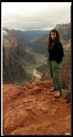
Zion Photo: Author of the site, Mary Cisneros, in Zion's Pine Creek Canyon. The North Fork of the Virgin River merges with the water from Pine Creek before it combines with the water from the East Fork of the Virgin River.
Zion Canyon Horse Trails - Horse rides in Zion Canyon are located at the Sand Bench Trailhead across the road from the Zion Lodge. This is the only trail in the park that commercial horse rides use.
Any other trail rides you see listed are on the edges of the park and not allowed inside the park itself.
For Reservations Call:435-679-8665
Zion Canyon Hiking Trails - Classic trails in Zion Canyon: Angels Landing, Hidden Canyon, Observation Point, Emerald Pools, Sand Bench Trail, Weeping Rock, Riverside Walk and Zion Narrows
|
|
Zion National Park, Utah
History of the Thunderbird
East Zion Lodge
Vacation House
Group Lodging
East Zion Golf
East Zion RV Park
Vacation Packages
Mileage from
Mt. Carmel Jct.
Zion National Park 12
Bryce Canyon 60
Grand Canyon 85
Cedar Breaks 45
Grand Staircase 9
Dixie Forest 22
Sand Dunes 11
Coyote Butte 57
Red Canyon 47
Tuweep 90
Stay in a hotel the heart of the parks, Mount Carmel Junction, and visit the treasures of the Southwest and Utah.
Site Map
Site Map II
Site Map III
Zion Hiking
Zion Park Hiking
Zion Hiking Advanced
Zion Canyoneering
Kolob Hiking
Greater Zion Area
|
A drive along either the Zion Canyon Scenic Drive through Zion Canyon or the Zion-Mt. Carmel Highway through the main park has few comparisons. |
"I don't know who Mary Cisneros is, but I mean zionnational-park.com
It's a better site than the NPS's anyway."
Written by the authors of the book: Favorite Hikes in and around Zion National Park
|
Zion History |
|---|
All rights reserved © Copyright Zion National-Park dot com
Do not use text, photos or maps without permission © Zion National-Park dot com
Contact the Author Mary Cisneros with any errors


