|
|

|
|||
|
Zion National Park Lodging Zion Info Vacation Weather Photos Hike Slot Canyons Backpack Camping |
||||

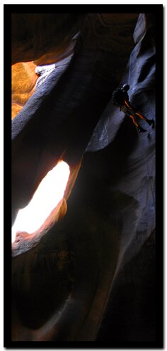
Pine Creek CanyonPine Creek is a technical slot canyon that is not only spectacular, but it has an easy off the highway entrance and a fairly easy exit. These two factors make it a popular slot canyon even though the actual slot is just as difficult as many of Zion slot canyons. The lighting in the cathedral of Pine Creek creates a mystical setting in the bowels of the canyon that draws canyoneers through its passage time and time again.
Call the Zion Canyon Visitors Center for weather conditions prior to the hike: (435) 772-3256. Hiking in slot canyons presents a very real danger from flash flooding. Do not hike this trail if it is raining. Remember a storm far off can trigger a flash flood. Pine Creek has a high flash flood danger Please let faster groups go past. Only 50 hikers are allowed in the canyon per day. Best Season: mid-June to mid-September when the water and air are warmer.
 At the parking lot at the east end of the Zion-Mt Carmel Tunnel drop into the wash to the southwest (immediately adjacent to parking lot) and turn right and walk under the bridge. At the parking lot at the east end of the Zion-Mt Carmel Tunnel drop into the wash to the southwest (immediately adjacent to parking lot) and turn right and walk under the bridge.
Approximately 100 yards downstream is the first obstacle. The first pool can be downclimbed on the left side, traversing into the chimney, and lowering into the watercourse at this chimney approximately 8'. Walk or swim through the pothole. The first bolt anchors are on the right just above the slickrock shoulder. This first rappel is done as a single stage - don't pull your rope when you touch down in the bowl 25' below; instead stay hooked into the rope and swim/walk to the narrow slot in the of the bowl and continue rappelling an additional 25-30' to the canyon floor. This canyon will and has changed many times over the course of years so exact information can and will become obsolete quickly. Continuing down canyon may present more swimming and scrambling soon. The next long drop that is encountered will follow a 10' drop from a logjam into a pool of water, then a swim around the corner to a slickrock slide. Be careful at this point, as the anchors for the drop into the "Cathedral" are located around the corner in this slickrock slide on the left side. This slide is often wet and slippery and sloping down to reach the anchors and a trip at this point could be disastrous.
Soon you'll find the canyon opening up and sunlight will be a welcome sight to warm up the bones. As you continue downstream, the terrain turns to large boulders that will have to be negotiated for a period of time. The second to last rappel will be done from a bolt anchor on the right side of the wash after you have weaved your way down the boulder filled wash. This rappel is done down a slickrock corner on a fairly low angle drop of about 60' into another bowl. Continue thru the narrow cut in the rock after you have reached the bottom of the wash. The canyon opens a bit with a few more boulders to negotiate, but this time you will bear to your left. You will come to the last 100' drop only by scrambling up a slab of slickrock on the left side of a large boulder in the watercourse. Note: There might be a large washed out hole to jump over to get to the 6' high slab on the left. If you missed the jump, you would certainly fall to your death or certain serious injury would occur. Scramble up the slickrock slab on the left and work your way up and downstream. Soon you will see a two bolt anchor down near the edge of the wash - drop-off. Be careful and set the last 100' rappel. This is the rappel that many have waited for as it is free-hanging most of the way into a lush seep-fed grotto. At the bottom of this exciting rappel, you are ready to remove wetsuits if you haven't already done so above the second to last rappel, and coil your ropes and prepare for the hike out using the exit trail. Stay in the watercourse proper and work thru the boulder fields for the next .75 mile, and arrive at vehicle stationed at the third switchback. Exit - Pine Creek
Option: station one vehicle at the fifth switchback (from canyon Jct. in the main canyon). This trailend requires that you hike the trail above Pine Creek on the south slope below the tunnel. Access to this trail requires that you scramble up the talus slope on your left as soon as you finish the last 100' overhanging rappel. (not suggested due to impact) Pine Creek HIking OptionsPine Creek Waterfall - Lower Pine Creek. Follow the water course all the way to the waterfall. This is a wonderful hike. Pine Creek Hike - Follow Pine Creek to the Skinny Dipping Pond and then up the hill side to the parking area. Shelf Canyon - This is a fun little slot diversion, located near the Canyon Overlook parking lot. Canyon Overlook - this short trail is one of the must do trails in Zion National Park, due to the spectacular view at the end. Technical Canyoneering: Never enter a semi-technical or technical canyon without the knowledge and skills needed to safely explore and return. Many technical canyons, also require GPS skills or excellent map reading skills to navigate.
GPS Coordinates WGS84 Datum Tunnel East Parking for Pine Creek:37°12.7980N 112°56.4270W 3rd Switchback optional Parking at end of Pine Creek Hike: Beta: Coordinates and other trail and canyoneering information by Zion Park search and rescue veteran team member Bo Beck and zionnational-park.com author Mary Cisneros. To post trip reports, offer corrections, updates, or for more information please visit the Zion National Park Forum Suggested Gear: A sturdy pair of shoes are recommend to hike the trails in Zion National Park. Many quality shoes will help grip the rocks and prevent injury. Freestanding Arches in Zion National Park
Zion National Park, UtahHistory of the Thunderbird |
East Zion Lodge Mileage from Stay in the heart of the parks, Mount Carmel Junction, and visit the treasures of the Southwest and Utah. Site Map Zion Hiking |
||||||||||||
|
This is my new favorite quote:
"I don't know who Mary Cisneros is, but I mean zionnational-park.com It's a better site than the NPS's anyway." Written by the authors of the book: Favorite Hikes in and around Zion National Park |
|||||||||||||

 This Canyon is a favorite of many "canyoneers" offering an easy approach, easy exit, minimal equipment needs, and logistics for shuttle are fairly simple. The canyon offers an absolutely delightful "slot canyon experience" with enough technicality that it provides the hiker with the thrill of much longer technical canyons.

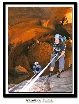
 Rappelling skills are required to navigate through this slot canyon. Remember slot canyons can change dramatically in a short time due to flash floods and water levels in this canyon change. These directions are only a general reference. Be prepared for variations in the canyon.
|
Zion History |
|---|
All rights reserved © Copyright Zion National-Park dot com
Do not use text, photos or maps without permission © Zion National-Park dot com
Contact the Author Mary Cisneros with any errors