|
|

|
|||
|
Zion National Park Lodging Park Info Vacation Weather Photos Hike SR-9 Slots Backpack Camping |
||||

Kolob Canyons
|
||||||||||||||
 Kolob Canyons
Directions to Zion National ParkFrom the North: Travel I-15 south, past Beaver. exit on Hwy 20. Follow US-89 to Mount Carmel Junction. Take SR-9 to Zion's east entrance.
|
|
|||
|
|
||||


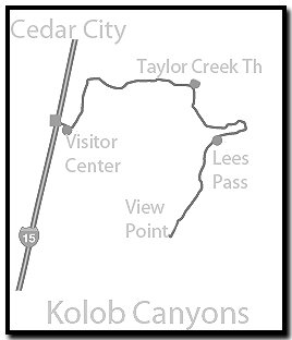
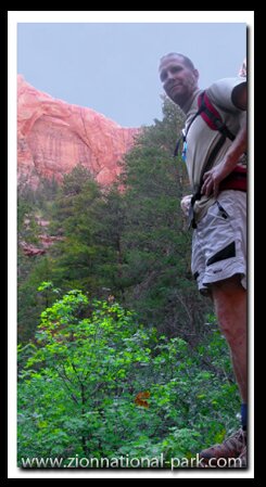
 Finger Canyons - There are five narrow valleys called "finger canyons" and as a result the area is often called Kolob Fingers by the locals rather than Kolob Canyons, the official name. The end of the scenic drive is an ideal place to stop and have a picnic, since there is no place to eat at the park, but there are picnic tables. The nearest services are in Cedar City which although small when compared to most cities it is one of the largest cities in the area. It is a charming college town where I went to college long ago when it was Southern Utah State College. Today it is Southern Utah University. There are a variety of environments in Kolob Canyons including some incredible technical slot canyons such as Kolob Creek (sometimes called Kolob Canyon which does confuse people) and Ice Box Canyon, but this section of Zion is best known for having one of the world’s longest arches - Kolob Arch.
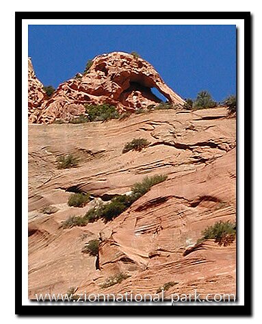
 World's Longest Arches - Once Kolob Arch was considered to be the longest natural arch in the world, but the newest method of measurement now has it listed as the second longest. Kolob Arch however will be standing long after, the world’s longest arch, the fragile Landscape Arch in Arches National Park falls. Landscape Arch was measured in 2004 by laser measurement and found to be 290 feet long. Kolob Arch was measure later, in 2006 and found to be 287 feet long. China has a couple of long arches which might actually be longer, but have yet to be measured by the newest methods.
Wildlife - The wildlife in Kolob Canyons seems to be an exaggerated version of what you see in Zion Canyon. Rattlesnakes are surprisingly common along the Middle Fork of Taylor Creek, but as far as I know, no human has ever been bit along the trail. When I hiked it with my kids we saw several rattlers, but unless you are looking you will probably never notice them. In all my years of hiking in Zion Canyon I have only seen one rattlesnake at that was on the Riverside Walk Trail. It was a fat, sleepy one, curled up under a bench. Tourists were all around it taking photos. A ranger came and bagged it and took it to a new location before I got to the end of the path and returned to the same location.
 Kolob Canyons Trails:
Timber Creek - Start this one-mile, round-trip hike, at the Kolob Canyons picnic area. It is a 100 foot ascent, following a ridge to a small peak. From the point you can see Timber Creek, Kolob Terrace and the Pine Valley mountains beyond Saint George. Plan on 30-minutes for the round-trip.
Middle Fork of Taylor Creek - The popular Middle Fork of Taylor Creek Trail is a 5.4-mile round-trip hike, past two homestead cabins and ending at a beautiful double arch water-streaked alcove with hanging gardens. This is an easy to moderate hike without much elevation change, but there is some shallow stream crossing. It should take about 3-hours to complete the trail.
North Fork of Taylor Creek - The North Fork of Taylor Creek is an un-maintained trail that begins at the heavily traveled Middle Fork of Taylor Creek Trailhead. It leaves the popular trail at the Larsen Cabin and goes to Pico Rosado, (Pink Spire, in Portuguese) a freestanding arch seen high on a cliff and then terminates between Horse Ranch Mountain and Tucupit Point.
South Fork of Taylor Creek - The 2-mile round-trip to the South Fork of Taylor Creek, is an un-maintained trail that begins about 3-miles past the Kolob Canyons Visitor Center, on an unmarked path. The path leads into the canyon between Paria Point and Beatty Point.
La Verkin Creek Trail – Kolob Arch – Begin at Lee’s Pass, following the La Verkin Creek Trail then take the spur to Kolob Arch. This can be done as a long day hike or as an overnight backpack.
Campgrounds – Other than backpacking, there is no camping in the Kolob Canyons. Kanarraville has a nice campground that is nearby.
|
|
Zion National Park, Utah
History of the Thunderbird

East Zion Lodge
Vacation House
Group Lodging
East Zion Golf
East Zion RV Park
Vacation Packages
Mileage from
Mt. Carmel Jct.
Zion National Park 12
Bryce Canyon 60
Grand Canyon 85
Cedar Breaks 45
Grand Staircase 9
Dixie Forest 22
Sand Dunes 11
Coyote Butte 57
Red Canyon 47
Tuweep 90
Stay in a hotel the heart of the parks, Mount Carmel Junction, and visit the treasures of the Southwest and Utah.
Site Map
Site Map II
Site Map III
Zion Hiking
Zion Park Hiking
Zion Hiking Advanced
Zion Canyoneering
Kolob Hiking
Greater Zion Area
|
Next: |
"I don't know who Mary Cisneros is, but I mean zionnational-park.com
It's a better site than the NPS's anyway."
Written by the authors of the book: Favorite Hikes in and around Zion National Park
|
Zion History |
|---|
All rights reserved © Copyright Zion National-Park dot com
Do not use text, photos or maps without permission © Zion National-Park dot com
Contact the Author Mary Cisneros with any errors