|
|

|
|||
|
Zion National Park Lodging Zion Info Vacation Weather Photos Hike Slot Canyons Backpack Camping |
||||

Observation Point
|
||||||||||||||

Directions to Zion National ParkFrom the North: Travel I-15 south, past Beaver. exit on Hwy 20. Follow US-89 to Mount Carmel Junction. Take SR-9 to Zion's east entrance.
|
|
|||
|
|
||||


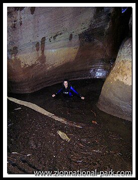
Echo Canyon -The hanging chasm of Echo Canyon is a delightful section of this trail. If water is running through the carved walls of the carved crevice then you will hear the rapid rush and cascading of the waterfalls. The first glance of this spectacular slot will be on the left side of the trail. The steep grade eases as the path leads to a lush setting and the trail becomes a wash. When the slot is dry, which is common during drought years in the summer months, it is possible to walk right into the slot canyon from this point and explore, but most of the time there are pools of frigid cold water forming unpleasant obstacles to overcome for the average hiker.
 East Rim Junction - All too soon the trail leads away from this delightful, flatter section of the trail, winding its way up the steep path toward the promontory of Mount Baldy. Open views are now the center of attention. Pass the spur to the East Rim Trail that would take hikers to the East Rim trailend near the park's east entrance.
The Mesa - The most stressful section of the trail is paved, but as the trail flattens out toward the top it turns to mixed sand and rock for about .75 miles. During winter months melting snow makes this area a slushy wet mess. Soon there is a signed junction where it is then 2.5 miles to the park boundary. Turn left at the junction, steering west and south toward Observation Point. At the end of the point the reward is some of the most impressive views in Zion National Park.
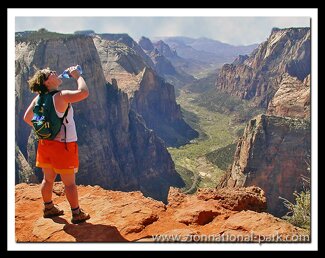
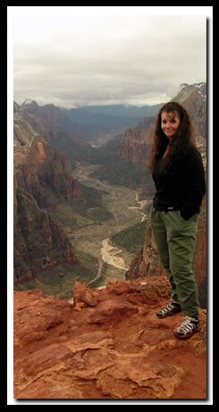
Observation Point - From the point, Angels Landing and the West Rim are to the right. Cathedral Mountain, Castle Dome and the Three Patriarchs are farther down the canyon but also to the right. To the left is the East Rim: Cable Mountain, Great White Throne, and at the far south section of the park is the Watchman.
Trail History - Few in the park ever use the name of the mountain where Observation Point sits, but is was named Mount Baldy in 1928 by Stephen S. Johnson. Before the switchbacks were built, in 1922, the hike was a grueling 18 miles. From the uppermost sections of the trail the Hidden Canyon, lower Observation Point and the West Rim Trails can all be seen.
 Options - From the Observation Point Trail you can take a peek into Echo Canyon, continue on the East Rim Trail, drive into East Zion and begin on the East Mesa Trail or take the side spur to Hidden Canyon.
Echo Canyon - Echo Canyon is a fun slot canyon with many high wall sections and eerie lighting that during the driest of years in the summer you might be able to explore parts of it. There are some areas blocked by boulders that will be difficult to climb up and down. A good climber should be part of the group. Be prepared for pools of neck high cold and even stagnant water. Canyoneers will explore the technical sections of the slot canyon from the top down. If you see people hiking up the trail with big backpacks and helmets, they are heading to the trailhead for the technical Echo Canyon route. The conditions in this slot canyon change and there is a flash flood danger. Check weather conditions before hiking. Permits are required for Echo Canyon. This is a popular canyoneering route in Zion.
Echo Canyon Non-technical Echo Canyon
East Rim Trail - 2 miles up the Observation Point Trail is the spur to complete the 10 mile East Rim Trail. The East Rim hike is most enjoyable when starting near the East Zion entrance station, so the trek along the steep path is downhill rather than an uphill climb and the views in that direction are impressive. The 10 miles does not include the spur to Observation Point.
East Mesa Trail - To take the East Mesa spur: Continue up the trail, past the junction to the East Rim Trail. Just a short distance from the trail-end, .3-miles, there is a sign directing hikers to the park boundary. Turn here. This trail is less scenic and is used mostly by canyoneers going to the technical slot canyon - Mystery Canyon.
Hidden Canyon - Hidden Canyon passes pools of water trapped in pockets of rock and ends in a hanging canyon. The canyon is a side-ravine between Cable Mountain and the north wall of the Great White Throne.
Beta: Coordinates and other trail and canyoneering information by Zion Park search and rescue veteran team member Bo Beck and zionnational-park.com author Mary Cisneros.
To post trip reports, offer corrections, updates, or for more information please visit the Zion National Park Forum
Suggested Gear: A sturdy pair of shoes are recommend to hike the trails in Zion National Park. Many quality shoes will help grip the rocks and prevent injury.
|
|
Zion National Park, Utah
History of the Thunderbird

East Zion Lodge
Vacation House
Group Lodging
East Zion Golf
East Zion RV Park
Vacation Packages
Family Reunion
Bus Tours
Business Retreat
Mileage from
Mt. Carmel Jct.
Zion National Park 12
Bryce Canyon 60
Grand Canyon 85
Cedar Breaks 45
Grand Staircase 9
Dixie Forest 22
Sand Dunes 11
Coyote Butte 57
Red Canyon 47
Tuweep 90
Stay in the heart of the parks, Mount Carmel Junction, and visit the treasures of the Southwest and Utah.
Site Map
Site Map II
Site Map III
Zion Hiking
Zion Park Hiking
Zion Hiking Adv.
Zion Canyoneering
Kolob Hiking
Greater Zion Area
|
|
"I don't know who Mary Cisneros is, but I mean zionnational-park.com
It's a better site than the NPS's anyway."
Written by the authors of the book: Favorite Hikes in and around Zion National Park
|
Zion History |
|---|
All rights reserved © Copyright Zion National-Park dot com
Do not use text, photos or maps without permission © Zion National-Park dot com
Contact the Author Mary Cisneros with any errors