|
|
 |
|||
|
Zion National Park Lodging Zion Info Vacation Weather Photos Hike Slot Canyons Backpack Camping |
||||

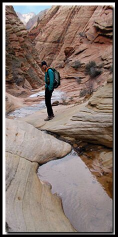
Spry Canyon HikeFor those that enjoy hiking up steep slickrock, this trail is a joy. The route is away from the mainstream of the park and the scenery is outstanding. The route begins by meandering through Upper Pine Creek. If you are lucky there will be a nice waterfall flowing. From the top of the slickrock saddle there are magnificent landmarks all around. To top off the hike there is a stream toppling over the mountain side at the end of the route. Canyoneers continue past this point by rappelling down the waterfall.
Best Season: This is a year-round route, but it is hot in the middle of summer and should only be accessed when the slick rock entrance is free of moisture, ice and snow. Avoid stepping on the black moss in the winter because when the moss fills with water, in the cold, it's as slippery as ice.
Directions Make your way up the slickrock, staying to the (west) right and heading for the slickrock bowl that lies beneath Deer Trap Mountain. Again, staying to the right, climb up the bowl. Toward the top of the bowl is a a tall, flat reddish slab of rock. Climb up the slickrock near the slab. The trail will flatten out on top of this section. Keep climbing up to the saddle. From here the scenery is magnificent. Note the East Temple (7709') to your left, the Twin Brothers (7709') and Deer Trap Mountain on your right, Mount Spry and the West Temple are straight ahead. See if you can make out the horse head in the West Temple. If you have not had enough you can descend to a beautiful downhill stream. Hike down hill, headed north, locating the water flow between the East Temple and the Twin Brothers. Follow the stream to where it flows steeply downhill. The water empties into Pine Creek below.
37°12.9265N 112°56.1408W Scramble up and Left Deertrap Petroglyphs GPS coordinates are only references and may or may not be accurate. Do not rely on GPS coordinates as the sole method of navigation. Always have an accurate, detailed map at hand and have the proper map reading and navigation skills before setting out on any hike. Many of the hikes listed in this guide travel into canyons where a GPS has limited capabilities. Always check your position with a detailed map before dropping into a canyon. Beta: Coordinates and other trail and canyoneering information by Zion Park search and rescue veteran team member Bo Beck and zionnational-park.com author Mary Cisneros. To post trip reports, offer corrections, updates, or for more information please visit the Zion National Park Forum Suggested Gear: A sturdy pair of shoes are recommend to hike the trails in Zion National Park. Many quality shoes will help grip the rocks and prevent injury.
Zion National Park, UtahHistory of the Thunderbird |
East Zion Lodge Mileage from Stay in the heart of the parks, Mount Carmel Junction, and visit the treasures of the Southwest and Utah. Site Map Zion Hiking |
||||||||||||
|
This is my new favorite quote:
"I don't know who Mary Cisneros is, but I mean zionnational-park.com It's a better site than the NPS's anyway." Written by the authors of the book: Favorite Hikes in and around Zion National Park |
|||||||||||||

 History: Looking on a map, Spry Canyon is seen between the Twin Brothers and the huge East Temple and is visible from the Zion Switchbacks and the Pine Creek route. Mount Spry was named after the English man, William Spry who served as a Utah governor between 1908-1916. Governor Spry fought against opposition to make changes which enhanced the quality of life for his people.

 GPS Coordinates WGS84 Datum
|
Zion History |
|---|
All rights reserved © Copyright Zion National-Park dot com
Do not use text, photos or maps without permission © Zion National-Park dot com
Contact the Author Mary Cisneros with any errors