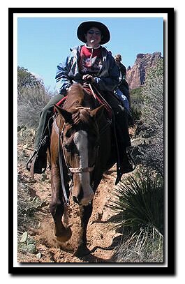
Kids and those wanting to take a horseback ride will enjoy this trail. Trail runners would be hard pressed to find a better path in the canyon. This trail can be hiked, but it's also used for the horse rides in Zion Canyon. Hiking is best done in late fall, winter and early spring when the trail ride (horse) concession is not in operation. If doing the hike during the time the trail rides are operating, be courteous and yield to the riders, and remain still and quiet as the horses pass by. The horses cause a phenomenon (I will refer to as "horse-di-doos") much like the large divots referred to as "whoop-di-doos" on motocross tracks. The difference is that in the bottoms of "horse-di-doos" also awaits "horsey-poos," thus making navigation even more of a challenge! Enough on the distractions and on to the hike. Named for its sandy path up on the bench. Early settlers used the trail to get up the canyon when floods made other ways difficult or impossible.
Sand Bench at a Glance Photo Album:Sand Bench Photos Trail Map:Trail Map-Backcountry Map-Overview Map Day Hike: Yes, but used by horses in the summer Distance: 3 miles Average Hiking Time: 3.5 hours Difficulty: Moderate Sun Exposure: Full sun in most parts of the trail, but the Junipers do provide some shade. Permits: Not required. Trail Conditions: This is a dirt path shared with horses. If dry, its a good path for trail runners who do not mind some soft sand. Trailhead: Court of the Patriarchs in Zion Canyon. Trailend: Same as trailhead Trail Access: Usually from April 1st until October 30th Zion Canyon is accessed via the shuttle. Private cars are allowed in Zion Canyon the rest of the year. Park at the Zion Canyon Visitor Center to ride the shuttle and get off at the Lodge. The rest of the year, when the shuttles are not operating, drive into the canyon and park across from the Lodge. Off the Beaten Path: No, but the trail gets little foot traffic. Classic Zion Hike: Yes Best Season: Late October to March, before the trail rides begin for the season. It's possible to avoid horses by hiking before 7am or after 5pm the rest of the year. Starting Elevation: 5183' at the bridge at trailhead. Total Ascent: 440 feet Total Descent: 440 feet Water Availability: Trail runs along the Virgin River and crosses a tributary, but it is easier to bring your own water. Restrooms: Near the bridge at the start of the hike and midway on the hike.
Sand Bench (Horse Trail) Loop Hike
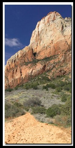
This trail offers a stroll along Birch Creek to the west and then ascends the plateau to the south known as Sand Bench. Views of the massive stone peaks of the Patriarchs, Sentinel, Streaked Wall, Twin Brothers, Mountain of the Sun, East Temple, Bridge Mountain, Watchman and Johnson Mountain all seem to be within a stones throw. Along the eastern flank of Sand Bench, the trail will periodically expose glimpses of the Left Fork of the Virgin River below as well as nice vistas to the south, showing a section of the Pa'rus Trail. If the shuttles are in operation, ride the shuttle from the Zion Canyon Visitors Center, the Zion Human History Museum or Canyon Junction. Get off at the stop following the Canyon Junction stop. This will be the Court of the Patriarchs viewpoint shuttle stop. Carefully cross the road to the west and notice the service road.
Directions to Zion National Park
From the North: Travel I-15 south, past Beaver. exit on Hwy 20. Follow US-89 to Mount Carmel Junction. Take SR-9 to Zion's east entrance.
From Arizona: Travel US-89A through Fredonia, Arizona and Kanab Utah. Follow US-89 to Mount Carmel Junction. Take SR-9 to the east park entrance.
From the South: Travel I-15 north. Take exit 16 and travel through Hurricane to LaVerkin. Continue on SR-9 to the south entrance of the park. SR-9 through Zion National Park is always open and is also called the Zion-Mt. Carmel Highway. See restrictions for RV's.
Zion Photo: The Sand Bench Trail begins at the same trailhead as Emerald Pools.
Lodging and services are available on the gorgeous east side of Zion National Park, where guests are close to Zion National Park (12 miles), Bryce Canyon National Park (60 miles), Cedar Breaks National Monument (45 miles), Coral Pink Sand Dunes (12 miles), and the North Rim of the Grand Canyon (85 miles). It's where city traffic is absent and the skies are bright and clean.
Either continue west on the service road or look for a dirt trail on the left bank above the service road. After walking past the maintenance area and water tank, look for the trail that leads to the bridge, crossing the Virgin River. Cross over the bridge where the trail branches right and left. Walk along Birch Creek for the next 200 yards, taking the left fork. The trail will cross onto the south side of Birch Creek and continue west for a short time along the bank of the creek. Soon the trail begins to ascend to the south and west, and will turn at several switchbacks until it arrives at another junction and a sign indicating the Sand Bench Loop Trail. By turning left, the majority of the ascent to the bench is on hard-pack and rock trail, versus by turning right, the majority of the ascent to the bench is in deep sand.
Any direction traveled will eventually arrive at the southern end of the bench, and the picnic area, hitching posts and vault toilet used by the trail rides. This is a nice area to relax in the shade of the junipers and pinions and prepare for the hike back to the trailhead.
Beta: Coordinates and other trail and canyoneering information by Zion Park search and rescue veteran team member Bo Beck and zionnational-park.com author Mary Cisneros.
To post trip reports, offer corrections, updates, or for more information please visit the Zion National Park Forum
Suggested Gear: A sturdy pair of shoes are recommend to hike the trails in Zion National Park. Many quality shoes will help grip the rocks and prevent injury.
Mileage from
Mt. Carmel Jct.
Zion National Park 12
Bryce Canyon 60
Grand Canyon 85
Cedar Breaks 45
Grand Staircase 9
Dixie Forest 22
Sand Dunes 11
Coyote Butte 57
Red Canyon 47
Tuweep 90
Stay in a hotel the heart of the parks, Mount Carmel Junction, and visit the treasures of the Southwest and Utah.
This is my new favorite quote:
"I don't know who Mary Cisneros is, but I mean zionnational-park.com
It's a better site than the NPS's anyway."
Written by the authors of the book: Favorite Hikes in and around Zion National Park


 Sand Bench (Horse Trail) Loop Hike