|
|

|
|||
|
Zion National Park Lodging Zion Info Vacation Weather Photos Hike Slot Canyons Backpack Camping |
||||

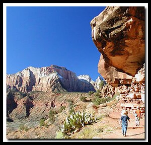
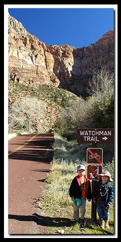
Watchman Trail
|
||||||||||||||


Directions to Zion National ParkFrom the North: Travel I-15 south, past Beaver. exit on Hwy 20. Follow US-89 to Mount Carmel Junction. Take SR-9 to Zion's east entrance.
|
|
|||
|
|
||||


![]() Trail History - The Watchman Trail was built by the Civilian Conservation Corps, or better known as the CCC. The finished 1934. At one time there was talk about extending the trail into Parunuweap Canyon but environmental conditions would not allow further construction. There was a trail built that went up the gully to the north of the actual Watchman. It was built with wooden ladders and was supposed to eventually lead to Parunuweap. The trail was never completed. In 1998 you could still hike up the gully to the shoulder using the ladders, but a year later a debris flow washed out a lot of the historical ladders.
Trail History - The Watchman Trail was built by the Civilian Conservation Corps, or better known as the CCC. The finished 1934. At one time there was talk about extending the trail into Parunuweap Canyon but environmental conditions would not allow further construction. There was a trail built that went up the gully to the north of the actual Watchman. It was built with wooden ladders and was supposed to eventually lead to Parunuweap. The trail was never completed. In 1998 you could still hike up the gully to the shoulder using the ladders, but a year later a debris flow washed out a lot of the historical ladders.
Beta: Coordinates and other trail and canyoneering information by Zion Park search and rescue veteran team member Bo Beck and zionnational-park.com author Mary Cisneros.
To post trip reports, offer corrections, updates, or for more information please visit the Zion National Park Forum
Suggested Gear: A sturdy pair of shoes are recommend to hike the trails in Zion National Park. Many quality shoes will help grip the rocks and prevent injury.
|
|
Zion National Park, Utah
History of the Thunderbird

East Zion Lodge
Vacation House
Group Lodging
East Zion Golf
East Zion RV Park
Vacation Packages
Family Reunion
Bus Tours
Business Retreat
Mileage from
Mt. Carmel Jct.
Zion National Park 12
Bryce Canyon 60
Grand Canyon 85
Cedar Breaks 45
Grand Staircase 9
Dixie Forest 22
Sand Dunes 11
Coyote Butte 57
Red Canyon 47
Tuweep 90
Stay in the heart of the parks, Mount Carmel Junction, and visit the treasures of the Southwest and Utah.
Site Map
Site Map II
Site Map III
Zion Hiking
Zion Park Hiking
Zion Hiking Adv.
Zion Canyoneering
Kolob Hiking
Greater Zion Area
|
|
"I don't know who Mary Cisneros is, but I mean zionnational-park.com
It's a better site than the NPS's anyway."
Written by the authors of the book: Favorite Hikes in and around Zion National Park
|
Zion History |
|---|
All rights reserved © Copyright Zion National-Park dot com
Do not use text, photos or maps without permission © Zion National-Park dot com
Contact the Author Mary Cisneros with any errors