|
|

|
|||
|
Zion National Park Lodging Park Info Vacation Weather Photos Hike SR-9 Slots Backpack Camping |
||||

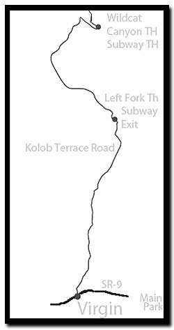
Kolob Terrace
|
||||||||||||||
 section of Zion National Park

Directions to Zion National ParkFrom the North: Travel I-15 south, past Beaver. exit on Hwy 20. Follow US-89 to Mount Carmel Junction. Take SR-9 to Zion's east entrance.
|
|
|||
|
|
||||


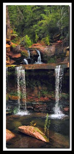
Left Fork of North Creek - Few know that you can hike into the Subway from the bottom and avoid the obstacles, cold water swimming and other uncomfortable parts of a technical slot canyon. You must still travel in small groups and a permit is still required. Those hiking from the bottom-up still count as part of the 80 allowed on the Subway route per-day.
Right Fork of North Creek - Plan to begin early in the day and be ready for a full day of hiking. The route leads to Double Falls and Barrier Falls. This is a very long hike through the creek leading to a photogenic waterfall.
Northgate Peaks Trail - This easy, family suited trail, follows the eastern edge of Pine Valley to a nice view point of the Guardian Angels of the Kolob. This easy trail is the start of the North Guardian Angel Trail.
North Guardian Angel - The North Guardian Angel is on the Sierra Clubs list of the" top one-hundred desert peaks to do." About 12-miles into the drive on the Kolob Terrace Road, there are some large “white Hershey kiss" shaped peaks. The sandstone mound to the right is Pine Valley Peak, (7428'). North Guardian Angel (7408') can be seen behind and to the right of Pine Valley Peak.
You cannot drive from the Kolob Terrace to Zion Canyon or to Kolob Canyons. You can however hike from Lava Point into Zion Canyon on the West Rim Trail and you can also hike on a trail to Kolob Canyons.
|
|
Zion National Park, Utah
History of the Thunderbird

East Zion Lodge
Vacation House
Group Lodging
East Zion Golf
East Zion RV Park
Vacation Packages
Mileage from
Mt. Carmel Jct.
Zion National Park 12
Bryce Canyon 60
Grand Canyon 85
Cedar Breaks 45
Grand Staircase 9
Dixie Forest 22
Sand Dunes 11
Coyote Butte 57
Red Canyon 47
Tuweep 90
Stay in a hotel the heart of the parks, Mount Carmel Junction, and visit the treasures of the Southwest and Utah.
Site Map
Site Map II
Site Map III
Zion Hiking
Zion Park Hiking
Zion Hiking Advanced
Zion Canyoneering
Kolob Hiking
Greater Zion Area
"I don't know who Mary Cisneros is, but I mean zionnational-park.com
It's a better site than the NPS's anyway."
Written by the authors of the book: Favorite Hikes in and around Zion National Park
|
Zion History |
|---|
All rights reserved © Copyright Zion National-Park dot com
Do not use text, photos or maps without permission © Zion National-Park dot com
Contact the Author Mary Cisneros with any errors