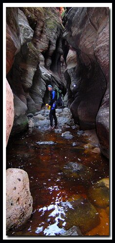
Das Boot is an ice cold, dark and skinny canyon that requires the use of a rope and wearing a wetsuit. The end of the canyon opens up into the popular and easier canyoneering route, the Subway.
At a Glance Photo Album:Das Boot Pictures Trail Maps:Das Boot Topo Map Distance: 10.8 miles Average time: 2 hours in Das Boot plus the Subway time of 7 hours. The Subway exit can be time consuming if not in good shape. Equipment: 60' rope, webbing, harness, rappel device, map, dry bag, sticky rubber shoes and a cold water wetsuit and neoprene socks. Technical: Up to 40' rappels, difficult downclimbing. Difficulty: Moderate off trail hiking. Technical canyon with swimming in cold pools. Good downclimbing skills are needed. ACA Canyon Rating: 3B III Permits: Required. Check the weather report before hiking this trail. Do not hike if it looks like rain Trailhead: Wildcat Trailhead - Kolob Terrace Trailend: Left Fork Trailhead - Kolob Terrace Trail Access: The Kolob Terrace Road. Cold temperatures deter most hikers in the winter months. Off the Beaten Path: Yes. Classic Zion Canyon: No Best Season: mid-June to mid-September when the water and air temperatures are warmer. Hazards: High flash flood danger. Call the Zion Canyon Visitors Center for weather conditions prior to the hike: (435) 772-3256. Hiking in slot canyons presents a very real danger from flash flooding. Do not hike this trail if it is raining. Remember a storm far off can trigger a flash flood.
Never enter a technical canyon without the knowledge and skills needed to safely explore and return. Rappelling and down-climbing skills are required to navigate through Behunin Canyon. Do not jump. Jumping in Zion's canyons have resulting in many broken bones. Many technical canyons, such as Birch Hollow, also require gps skills or excellent map reading skills to navigate.
Das Boot - Das Boot is an addition to the traditional Subway Hike that can be enjoyed by those wanting a "step up" in adventure from the standard "Subway" route. This hike will add an additional 1.5 miles to the standard Subway Route (Approximately) and an additional 2-3 hours of hiking - scrambling - downclimbing - rappelling to the standard Subway Route.
Mileage:
2.5 miles: cross over Russell gulch
3.75 miles to the drainage head to drop into Das Boot
4.5 miles: Left Fork of North Creek and Das Boot
5.2 miles: Junction of Das Boot and Russell Gulch
Total miles: exit Left Fork Trailhead 10.75 miles.
Directions to Zion National Park
From the North: Travel I-15 south, past Beaver. exit on Hwy 20. Follow US-89 to Mount Carmel Junction. Take SR-9 to Zion's east entrance.
From Arizona: Travel US-89A through Fredonia, Arizona and Kanab Utah. Follow US-89 to Mount Carmel Junction. Take SR-9 to the east park entrance.
From the South: Travel I-15 north. Take exit 16 and travel through Hurricane to LaVerkin. Continue on SR-9 to the south entrance of the park. SR-9 through Zion National Park is always open and is also called the Zion-Mt. Carmel Highway. See restrictions for RV's.
Lodging and services are available on the gorgeous east side of Zion National Park, where guests are close to Zion National Park (12 miles), Bryce Canyon National Park (60 miles), Cedar Breaks National Monument (45 miles), Coral Pink Sand Dunes (12 miles), and the North Rim of the Grand Canyon (85 miles). It's where city traffic is absent and the skies are bright and clean.
Das Boot Trailhead - Leave the main section of Zion Park and drive along SR-9 to the small town of Virgin. Turn onto the Kolob Terrace Road (Kolob Reservoir) heading north for approximately. 9 miles and park at the Left Fork Trailhead (first car) then continue north to the Wildcat Canyon Trailhead approximately. 8 miles to begin the Das Boot Hike.
The standard Subway Route begins at the Wildcat Canyon trailhead, and will follow the Wildcat Canyon Trail for 1 mile until coming to the Northgate Peaks Trail junction. Turn right at the junction onto the Northgate Peaks trail and follow it for approximately 200 yards. At this point there is a sign that indicates the "Left Fork of North Creek" and the "Subway". The trail crosses slickrock and descends to the southeast toward Russell Gulch. This trail is fairly easy to follow when in the forested areas, but on the slickrock watch for rock cairns. Travel this trail down towards Russell Gulch for approximately .5 miles then leave the trail to the east-north-east, finding the easiest path toward the bottom of Russell Gulch. Not far down steer more northerly toward the head of Russell Gulch to avoid dropping down and then having to climb back out of Russell Gulch. By staying High and contouring to the north you will be able to cross over on to the east side of the gulch with minimal elevation loss. Once on the east side of Russell Gulch traverse south-easterly gaining elevation to gain a slickrock ledge system - ridge and travel approximately .5 mile to the south-south-east staying at a fairly level elevation (Not up, and not down). Soon you will see Wildcat Canyon peeking from the corner to the east and hiking now toward Wildcat Canyon to the east you will soon encounter a prominent drainage that runs southerly into the Left Fork drainage to your right and and below. This is the ticket into Das Boot. Carefully working down this drainage for about .5 miles will put you into the Left Fork and the start of Das Boot. From this point have your wetsuit on and zipped up, anything you want kept dry stored in dry bags and your sense of adventure primed and ready. Double bag cameras in a wet canyon like Das Boot.
Das Boot - Rappelling skills, the ability to downclimb difficult obstacles and get off rappel while in keep in water are required to navigate through this slot canyon. Remember slot canyons can change dramatically in a short time due to flash floods and water levels in this canyon change. These directions are only a general reference. Be prepared for variations in the canyon.
There will be several downclimbs into cold pools that must be swam, and you should have 60' of rope to negotiate rappels that you may not feel comfortable downclimbing. Although this additional .75 mile stretch of Left Fork of North Creek may seem short, it will provide long lasting memories of a spectacular, narrow slot canyon that tempts the adventure in all of us.
Beware: Das Boot presents difficult problems that need to be solved and only should be attempted if you have downclimbing skills and chimneying experience. To attempt this canyon without the proper equipment i.e. wetsuit and rope, could lead to serious consequences.
GPS Coordinates WGS84 Datum
Wildcat Trailhead
37°20.4512 N
113°4.5081 W
Cross over Russell Gulch to
the East side at:
37°19.6818 N
113°2.6851 W
Start Down Drainage to Das Boot at: 37°19.5681 N
113°1.9890 W
GPS coordinates are only references and may or may not be accurate. Do not rely on GPS coordinates as the sole method of navigation. Always have an accurate, detailed map at hand and have the proper map reading and navigation skills before setting out on any hike. Many of the hikes listed in this guide travel into canyons where a GPS has limited capabilities. Always check your position with a detailed map before dropping into a canyon.
Beta: Coordinates and other trail and canyoneering information by Zion Park search and rescue veteran team member Bo Beck and zionnational-park.com author Mary Cisneros.
To post trip reports, offer corrections, updates, or for more information please visit the Zion National Park Forum
Suggested Gear: A sturdy pair of shoes are recommend to hike the trails in Zion National Park. Many quality shoes will help grip the rocks and prevent injury.
Mileage from
Mt. Carmel Jct.
Zion National Park 12
Bryce Canyon 60
Grand Canyon 85
Cedar Breaks 45
Grand Staircase 9
Dixie Forest 22
Sand Dunes 11
Coyote Butte 57
Red Canyon 47
Tuweep 90
Stay in a hotel the heart of the parks, Mount Carmel Junction, and visit the treasures of the Southwest and Utah.
This is my new favorite quote:
"I don't know who Mary Cisneros is, but I mean zionnational-park.com
It's a better site than the NPS's anyway."
Written by the authors of the book: Favorite Hikes in and around Zion National Park


 Beware: Das Boot presents difficult problems that need to be solved and only should be attempted if you have downclimbing skills and chimneying experience. To attempt this canyon without the proper equipment i.e. wetsuit and rope, could lead to serious consequences.