Shelf Canyon is a fun little trek on the east side of Zion National Park. It takes a bit of boulder hopping to explore, but beyond some easy obstacles it's a short stroll through a pretty part of the park and offers the visitor, who may have minimal hiking skills, equipment, and limited time, an opportunity to explore a true slot canyon. Hoodoos, tall thin spires of rock, decorate from the onset with the first attention grabber sitting high on a lofty perch to the left. During the wetter times of the year, a refreshing trickle of water spills down the mountainside providing ferns below with enough water to thrive in this shady little haven. Lush evergreens add a touch of year-round green to the spectrum of colors along the hike and contrast with towering tangerine colored rock. Toward the termination of the route, walls close in forming a short, yet impressive, slot until the path completes at a series of shelves - thus the name Shelf Canyon. Like much of the hiking on the east side of the park, this is a good winter excursion when the slickrock is dry.
At a Glance
Photo Album: Shelf Canyon Photos
Trail Map:Shelf Canyon Map
Day Hike: Yes
Distance: 1 mile round-trip.
Average Hiking Time: 1 hour round-trip Sun Exposure: There is enough sun for this to be an enjoyable winter hike and enough shade for it to be nice in the summer as well. Trail Usage: This canyon is near one of the most used paths in the park, the Canyon Overlook Trail, but, after dropping into Shelf Canyon, you will usually have it to yourself.
Permits: Not required. Trail Conditions: Expect a sandy path through a short, usually dry drainage, with a couple of spots where rocks are difficult to pass and must be scaled. Like all slot canyons, this is a flash flood area. Trailhead: Canyon Overlook parking lot. Trailend: Same as starting point. Trail Access: The Zion-Mt. Carmel Highway is open year-round and this trail begins just off the highway. Best Season: March - October, but it's a good winter hike if the drainage is dry. Elevation: Trailhead: 5200 feet Trailend: 5300 feet Off the Beaten Path: The slot itself is usually quiet and deserted. Restrooms: Located at the Canyon Overlook Trailhead
Directions to Zion National Park
From the North: Travel I-15 south, past Beaver. exit on Hwy 20. Follow US-89 to Mount Carmel Junction. Take SR-9 to Zion's east entrance.
From Arizona: Travel US-89A through Fredonia, Arizona and Kanab Utah. Follow US-89 to Mount Carmel Junction. Take SR-9 to the east park entrance.
From the South: Travel I-15 north. Take exit 16 and travel through Hurricane to LaVerkin. Continue on SR-9 to the south entrance of the park. SR-9 through Zion National Park is always open and is also called the Zion-Mt. Carmel Highway. See restrictions for RV's.
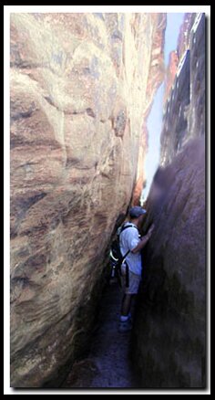
The walls close in near the end of the Shelf Canyon, as it forms a tight slot. This short slot gives Zion's visitors a taste of a slot canyon. The parking area, however, is near a classic hike, the Canyon Overlook Trail, so it can be difficult to find parking.
Lodging and services are available on the gorgeous east side of Zion National Park, where guests are close to Zion National Park (12 miles), Bryce Canyon National Park (60 miles), Cedar Breaks National Monument (45 miles), Coral Pink Sand Dunes (12 miles), and the North Rim of the Grand Canyon (85 miles). It's where city traffic is absent and the skies are bright and clean.
Trailhead - Look for the Canyon Overlook Trail parking lot near the east side of the Zion-Mt. Carmel Tunnel. Shelf Canyon is 250 yards east of this parking lot and 300 yards west of the Upper Pine Creek drainage. The entrance to the canyon is an unsigned area on the north side of the highway, so peer over the edge to find the path of use and then drop into the sandy drainage. There are a group of hoodoos at the top of the sandstone cliff above and some fun rock formations to navigate around. A stone slab with lateral engravings is the first climbing obstacle. Toward the end of the path walls close in to make a short, but narrow slot. Rocks clutter into the passage and a series of horizontal ledges or shelves prevent further exploration. Climbing at the end of the canyon is tempting, however strongly discouraged.
Shelf Canyon Trail: This drainage is often called Shelf Canyon because the many shelf-like rock layers. Steve Ramras (Ram), well known canyoneer, named the canyon.
Best Trail Features: Like much of the east side hiking, Shelf Canyon is a good winter route when dry. This is a great little hike away from the crowds that is fun and easy.
GPS Coordinates WGS84 Datum
Trailhead
37°12.898 N
112°56.343 W
Trailend
37°13.122 N
112° 56.376 W
GPS coordinates are only references and may or may not be accurate. Do not rely on GPS coordinates as the sole method of navigation. Always have an accurate, detailed map at hand and have the proper map reading and navigation skills before setting out on any hike. Many of the hikes listed in this guide travel into canyons where a GPS has limited capabilities. Always check your position with a detailed map before dropping into a canyon.
Beta: Coordinates and other trail and canyoneering information by Zion Park search and rescue veteran team member Bo Beck and zionnational-park.com author Mary Cisneros.
To post trip reports, offer corrections, updates, or for more information please visit the Zion National Park Forum
Suggested Gear: A sturdy pair of shoes are recommend to hike the trails in Zion National Park. Many quality shoes will help grip the rocks and prevent injury.
Mileage from
Mt. Carmel Jct.
Zion National Park 12
Bryce Canyon 60
Grand Canyon 85
Cedar Breaks 45
Grand Staircase 9
Dixie Forest 22
Sand Dunes 11
Coyote Butte 57
Red Canyon 47
Tuweep 90
Stay in the heart of the parks, Mount Carmel Junction, and visit the treasures of the Southwest and Utah.
This is my new favorite quote:
"I don't know who Mary Cisneros is, but I mean zionnational-park.com
It's a better site than the NPS's anyway."
Written by the authors of the book: Favorite Hikes in and around Zion National Park


 Trailhead