|
|

|
|||
|
Zion National Park Lodging Park Info Vacation Weather Photos Hike SR-9 Slots Backpack Camping |
||||

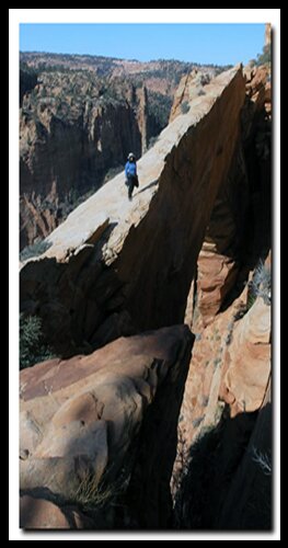
Squirrel Canyon - Water Canyon Loop including Water Canyon ArchThis 11 plus mile loop hike with 2900' of climbing and an equal amount of descending is a workout, but the natural beauty and adventure certainly makes the trip worth it. From the juniper speckled desert floor to ponderosa pine forests, expansive sandstone slickrock fields dotted with hoodoos, a narrow slot canyon and even a walk to an arch suspended 1000' above the canyon floor make this hike a great way to spend a day. The best time to do this loop hike is in the spring after the snow has melted or in the fall before snow has fallen. Hot summer months would be unpleasant, and snow and ice in the winter months may make hiking hazardous.
Squirrel Canyon - After parking your vehicle at the fence with a gate, look across the wash (east) and notice an old road. This is the trail leading up Short Creek and Squirrel Creek. Begin the hike by dropping into the Water Canyon Wash just below and east of the parking area, then follow the track up and out of the wash onto the ridge on the opposite side. Follow this path back into Short Creek and continue northeast along the creek for 1.4 miles until you find an intersection of ATV roads. At this point, Beehive Mountain will be almost due north and towering above. At this intersection, cross the creek to the left and walk north up Squirrel Creek. Initially the trail climbs onto a ridge to the west of Squirrel Creek, and eventually will drop into and cross over the creek below. The trail is well used and easy to follow. At 2.5 miles the trail is now on the east side of the creek and begins a steep ascent up rocky ledge systems to gain the top of a ridge that separates two drainage's near the head of Squirrel Creek Canyon. Beehive Mountain and views to the south are now spectacular as travel continues north following a steep ridge. About 3.75 miles into the hike and at the top of the ridge, the Canaan Mountain Trail is met. The vistas and scenery just continue to unfold the higher the trail gets. At this intersection turn left (west) traveling toward a large slickrock ridge towering above and to the north. The trail will drop into a slickrock wash at the base of this large rock ridge and continue west. Water Canyon Arch - After a mile of traveling west from the intersection of Squirrel Creek Trail and Canaan Mountain Trail, look left and there may or may not be a trail(s) that leads south along the ridge. In any case, begin traveling south- east along the ridge, keeping an eye to the right at Water Canyon below. Stay as high as possible as travel continues southeast and try to keep Water Canyon in view if possible. At times it will be necessary to stray away from the rim above the canyon, but then always try to get back close to the rim. After a mile and bypassing a large sandy bowl on hikers right, (several rock outcrops at the bottom of the bowl hide views of Water Canyon) walk around the right side of a small rock outcrop just to the south of this bowl, and drop down a sandy hill to arrive at Water Canyon Arch. From the arch, look north northeast at the skyline and locate the white domes. White Domes - The domes will be the next landmark to hike toward and the intersection of the next leg of travel. Enjoy lunch at the arch, dump the sand out of shoes, hydrate and prepare for the second leg of the trip. Follow your footsteps back to Canaan Mountain Trail. The trail now will follow a wide slickrock wash upward for .25 mile and then bear left and out of the wash traveling upward along a rocky ridge another .25 mile before picking up the sandy Canaan Mountain Trail. Follow the Canaan Mountain Trail another .65 mile west until arriving at the White Domes. These domes, with Zion National Park in the background are quite photogenic. Exit Canaan Mountain - Travel is now downhill for most of the remainder of the trip. Walk down the massive slickrock field to the southeast. Do not try to walk through the slot canyons on the right, rather, stay left and bear toward the small multicolored domes to the left of the slot. Travel down the slickrock is somewhat steep in sections but it is not difficult. After a half mile you will arrive at the bottom of the wash. Walk down the pleasant sandy drainage for another half mile to the intersection of another wash entering from the right and turn left following the wash downstream. After a quarter mile downstream from the intersection of the two washes, look for a path of travel to the right and up the ridge above. If a path cannot be located, start climbing the ridge upward in a southeast direction and traverse looking for a path. Once located, the path will eventually arrive at Top Rock. Water Canyon - From Top Rock. there are great views back to the White Domes and views of Water Canyon below. The Water Canyon Trail now becomes more visible as it drops off from Top Rock. to the east and begins its steep descent into Water Canyon and the Water Canyon Trailhead now a mile and half away. The trail will follow ledges and wind its way down eventually arriving at the bottom of the slot canyon. Soon the trail leaves the confinement of the slot and follows the hillside above the creek. Be sure to look high up on the left to view the Water Canyon Arch you visited as travel continues down canyon. Before you know it, the parking area at the Water Canyon Trailhead comes into view. If a shuttle was stationed here you are done hiking. If not, then it's an easy one-mile walk back down the road to your waiting vehicle at the Short Creek - Squirrel Creek Trailhead. Options - Water Canyon to Eagle Crags backpack
Trailhead and Parking Intersection of Squirrel Creek Trail with Short Creek Trail: Intersection of Canaan Mountain Trail and Squirrel Creek Trail Intersection of Trail to Water Canyon Arch and Canaan Mountain Trail Water Canyon Arch White Hoodoos and Descent down Slickrock toward top of Water Canyon Top Rock and Trailhead to descend Water Canyon Parking Lot at Trailhead of Water Canyon Rockville, Utah - Rockville is located on the south side of Zion National Park. This is a small community of less than 250 people. Smithsonian Butte Highway map photos - The unpaved Smithsonian Butte National Back Country Byway runs from Rockville, located on the south side of Zion National Park, for 9 miles. It comes out 8 miles northwest of Hildale (east of Hurricane) at Utah Highway 59 (AZ Highway 389). This scenic drive has great views of Canaan Mountain, the Vermillion Cliffs and Zion National Park. The road was named by John Wesley Powell. Option - Day hike to Canaan Mountain and back. GPS coordinates are only references and may or may not be accurate. Do not rely on GPS coordinates as the sole method of navigation. Always have an accurate, detailed map at hand and have the proper map reading and navigation skills before setting out on any hike. Many of the hikes listed in this guide travel into canyons where a GPS has limited capabilities. Always check your position with a detailed map before dropping into a canyon. Freestanding Arches in Zion National Park
To post trip reports, offer corrections, updates, or for more information please visit the Zion National Park Forum Suggested Gear: A sturdy pair of shoes are recommend to hike the trails in Zion National Park. Many quality shoes will help grip the rocks and prevent injury.
Zion National Park, UtahHistory of the Thunderbird |
East Zion Lodge Mileage from Stay in a hotel the heart of the parks, Mount Carmel Junction, and visit the treasures of the Southwest and Utah. Site Map Zion Hiking Southern Utah Backways |
||||||||||||
|
This is my new favorite quote:
"I don't know who Mary Cisneros is, but I mean zionnational-park.com It's a better site than the NPS's anyway." Written by the authors of the book: Favorite Hikes in and around Zion National Park |
|||||||||||||

 Directions to Hildale, Utah -


 GPS Coordinates WGS84 Datum
|
Zion History |
|---|
All rights reserved © Copyright Zion National-Park dot com
Do not use text, photos or maps without permission © Zion National-Park dot com
Contact the Author Mary Cisneros with any errors