|
||||
|
Zion National Park Lodging Park Info Vacation Weather Photos Hike SR-9 Slots Backpack Camping |
||||
Water Canyon to Canaan Mountain Day HikeThe pristine BLM designated wilderness of Canaan Mountain is a unique masterpiece of visual imagery. Along the mountain path, leading past one of the most dazzling views of Zion National Park anywhere and on to a historic windlass, you will walk through a chasm of delightful waterfalls and glimpse into the depths of a narrow slot canyon. You will also traverse massive slickrock bowls, wander ponderosa dotted dunes and stand in awe of magnificent white domes, hoodoos and a cornucopia of stepped rock. You will find yourself totally absorbed throughout the journey as stunning vistas unfold.
Trailhead - Hildale, Arizona is located just off AZ Highway 389 between Hurricane, Utah and Fredonia, Arizona. From the highway, enter Hildale using Utah Avenue. Follow the paved road for about 3-miles, looking for the dirt road on the right that leads to Water Canyon. If you see Hildale's city park then you have missed the road to Water Canyon. There is an intersection a little more than a half-mile up the dirt road. Stay left at the intersection. There is a small reservoir about 2 miles up the road. Continue to the end of the road where there is an unsigned parking area for the Water Canyon Trail.
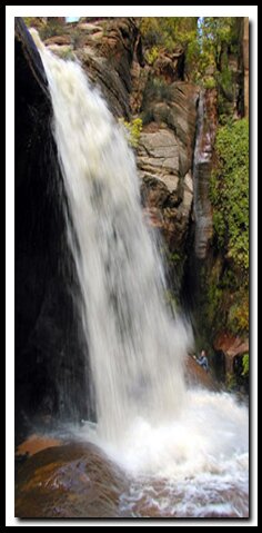
Water Canyon - The trail begins by skirting the west side of Water Canyon and gradually ascending through junipers on a well traveled dirt path. After a mile or so the walls begin to enclose. Search the skyline to the right to get a peek at Water Canyon Arch which sits on a perch 1000' above the canyon floor . Farther north the canyon walls narrow and travel is in the waterway and up a stepped waterfall. The trail scales left above the waterway and contours above the ever restricting slot canyon. The sculpted slot below has become a popular destination for instructors leading guided canyoneering trips. Soon the trail begins a steeper ascent as it leaves the canyon bottom, and leads farther north before ascending to the rim above Water Canyon. After several switchbacks, the steep trail leads to "Top Rock" and the end of the Water Canyon Trail. To the east and north there is a showcase of slickrock fields and the watershed that carved the narrow passage through the soft sandstone below. Canaan Mountain - The path now becomes a route rather than a trail. A map and route finding skills are required to hike past Top Rock. Descend northwest through the forest and drop into the wash below. Once in the wash, the beaten-path evaporates but make your way by following the wash upstream for about a quarter-mile. Another wash enters from the north (right). Turn right into this wash and you should find easy travel. After about a half-mile in this wash, begin ascending the slab slickrock on the right. The hiking is reasonably easy as you hike up the slickrock traveling in a generally northwest direction toward the white domes and white hoodoos at the top of Canaan Mountain. From this area be sure to soak in the views of Zion National Park, Bryce Canyon, Cedar Breaks and the White Cliffs that rim the Grand Staircase-Escalante National Monument. Just on top and behind the white domes there is an old dirt road. The route now follows the road to the west through the ponderosa dunes and periodically skirts the slickrock rim. Views unfold both north toward Zion and south to the Canaan Mountain ridges and valleys. Notch - Travel west, about 2-miles past the white domes toward a prominent gap at the rims edge where there are wonderful views of Canaan Ranch and the valley to the south. Historic Windlass - Just a short distance west, beyond the notch are the remnants of the cable system that was used to lower timber to the valley below via an elaborate guiding cable. Although this route can continue as a two day hike all the way to Rockville, now is the time to break for lunch, shake the sand from your shoes and socks and prepare for the trek back to Water Canyon and your awaiting vehicle. Options - Water Canyon to Eagle Crags backpack GPS Coordinates WGS84 Datum
Stair-step Waterfall in Water Canyon 37°02.977 N Top Rock (Canaan Mountain): White Domes (Hoodoos) Black Rocks The Notch The Windlass Freestanding Arches in Zion National Park
To post trip reports, offer corrections, updates, or for more information please visit the Zion National Park Forum Suggested Gear: A sturdy pair of shoes are recommend to hike the trails in Zion National Park. Many quality shoes will help grip the rocks and prevent injury.
Zion National Park, UtahHistory of the Thunderbird |
East Zion Lodge Mileage from Stay in a hotel the heart of the parks, Mount Carmel Junction, and visit the treasures of the Southwest and Utah. Site Map Zion Hiking Southern Utah Backways |
||||||||||||
|
This is my new favorite quote:
"I don't know who Mary Cisneros is, but I mean zionnational-park.com It's a better site than the NPS's anyway." Written by the authors of the book: Favorite Hikes in and around Zion National Park |
|||||||||||||
|
Zion History |
|---|
All rights reserved © Copyright Zion National-Park dot com
Do not use text, photos or maps without permission © Zion National-Park dot com
Contact the Author Mary Cisneros with any errors


 Parking in Water Canyon