border

Parunuweap Canyon - Fat Man's Misery with Elephant Butte 4WD Exit

Options

1. The Hike which avoids the technical slot canyon

2. Loop from Zion and back

3. Zion to an exit at Elephant Butte

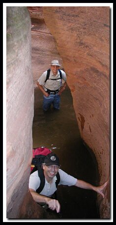
This is the ideal slot canyon adventure and one of the most beautiful places in Southern Utah. The hike in is decorated with charming water filled pot holes. which summer months bring canyon tree frogs to the pools displaying all stages of development. The slot canyon lures canyoneers to its bowels. Fat Man's Misery twists, turns and winds, offering rock slides, a couple of interesting rappels and enough difficulty to keep even hard core canyoneers interested. The narrow slot canyon has it all: trees wedged between the falls, bouldering, slides, warm pools, cold pools, sandy bottoms, towering canyon walls and a couple of fun rappels. The East Fork of the Virgin River (Parunuweap Canyon) is as impressive as the popular Zion Narrows but set in a more remote and wild environment. There are few adventures that can compare with a trip through Parunuweap, one of the Southwest's most outstanding canyons. However, this canyon is not the place for those without rappelling, downclimbing, rope and route finding skills. This route is through a wilderness area offering little hope of running into other humans. Know your limits.

Zion Book: Favorite Hikes in and around Zion National ParkParunuweap Canyon at a Glance
Photo Album: Approach Photos More Photos
Trail Maps:
Map 1 Map 2 Map to Elephant Butte Exit
Day hike:
Yes, but would be a nice backpack.
Distance: 9 miles from Checkerboard to the Elephant Butte Exit.
Average hiking time: 12 hours
Equipment: 100' rope, webbing, harness, rappel device, map, dry bag, helmet, emergency supplies and lots of water.
Technical: At least 4 short rappels or downclimb's. One optional rappel is 50'. The required rappel is 35' and overhanging'. Two shorter rappels can be downclimbed with a hand-line.
Difficulty: Strenuous hiking, river hiking. Technical canyoneering through Fat Man's Misery Slot Canyon. Downclimbing skills are required.
Permits: No permit is required because the technical section is outside Zion National Park on BLM land. Check the weather report before hiking this trail. Do not hike if it looks like rain or rain in the Alton area, which is near the head of the East Fork of the Virgin River.
Trailhead: The pullout just southwest of the main Checkerboard Mesa viewpoint.
Trailend: Elephant Butte
Trail access: The Zion Mt. Carmel Hwy is open year-round. Cold river temperatures and heavy current can deter most hikers in the winter months.
Off the Beaten Path: Yes
Best season: mid-June to mid-September when the water is warmer.
Hazards: Call the Zion Canyon Visitors Center for weather conditions prior to the hike: (435) 772-3256. Hiking in slot canyons presents a very real danger from flash flooding. Do not hike this trail if it is raining. Remember a storm far off can trigger a flash flood. Poison Ivy is present in many places along the river and in the exit canyon.
Southern Utah Flash Flood info.
North Fork Virgin River - Flash Flood Info

Parunuweap is a slot canyon and like any slot canyon there is a very real danger from flash flooding. Do not hike this trail if it is raining. Remember a storm far off can trigger a flash flood. Flash flood danger is high.

Map: Zion National Park Coral Pink Sand Dunes Map Grand Staircase-Escalante Map Bryce Canyon National Park Grand Canyon National Park, Arizona - North Rim Map Red Canyon, Dixie National Forest, Utah Lodging: Zion National Park Cedar Breks National Monument, Utah Dixie National Forest: Cedar Mountain Zion National Park State Road 9 - Zion-Mt. Carmel Highway Southern Utah Scenic Byways Zion National Park Map Coral Pink Sand Dunes Map Zion National Park Lodging Cedar Breaks and Dixie National Forest Map Bryce Canyon and Red Canyon Map Grand Staircase-Escalante Map Zion National Park Map Coral Pink Sand Dunes Map Zion National Park Lodging Cedar Breaks and Dixie National Forest Map Grand Staircase-Escalante Map Bryce Canyon National Park Zion National Park Map Coral Pink Sand Dunes Map Zion National Park Lodging Cedar Breaks and Dixie National Forest Map Bryce Canyon and Red Canyon Map Grand Staircase-Escalante Map Zion National Park Map Coral Pink Sand Dunes Map Zion National Park Lodging Cedar Breaks and Dixie National Forest Map Grand Staircase-Escalante Map Bryce Canyon National Park Zion National Park Map Coral Pink Sand Dunes Map Zion National Park Lodging Cedar Breaks and Dixie National Forest Map Bryce Canyon and Red Canyon Map Grand Staircase-Escalante Map Zion National Park Map Coral Pink Sand Dunes Map Zion National Park Lodging Cedar Breaks and Dixie National Forest Map Bryce Canyon and Red Canyon Map Grand Staircase-Escalante Map Zion National Park Map Coral Pink Sand Dunes Map Zion National Park Lodging Cedar Breaks and Dixie National Forest Map Grand Staircase-Escalante Map Bryce Canyon National Park Zion National Park Map Coral Pink Sand Dunes Map Zion National Park Lodging Cedar Breaks and Dixie National Forest Map Bryce Canyon and Red Canyon Map Grand Staircase-Escalante Map Zion National Park Map Coral Pink Sand Dunes Map Zion National Park Lodging Cedar Breaks and Dixie National Forest Map Grand Staircase-Escalante Map Bryce Canyon National Park Zion National Park Map Coral Pink Sand Dunes Map Zion National Park Lodging Cedar Breaks and Dixie National Forest Map Bryce Canyon and Red Canyon Map Grand Staircase-Escalante Map Zion National Park Map Coral Pink Sand Dunes Map Zion National Park Lodging Cedar Breaks and Dixie National Forest Map Bryce Canyon and Red Canyon Map Grand Staircase-Escalante Map Zion National Park Map Coral Pink Sand Dunes Map Zion National Park Lodging Cedar Breaks and Dixie National Forest Map Bryce Canyon and Red Canyon Map Grand Staircase-Escalante Map Coral Pink Sand Dunes Map Grand Staircase-Escalante Map Bryce Canyon National Park Grand Canyon National Park, Arizona - North Rim Map Red Canyon, Dixie National Forest, Utah Lodging: Zion National Park Zion National Park Cedar Breks National Monument, Utah Dixie National Forest: Cedar Mountain Zion National Park Map Coral Pink Sand Dunes Map Zion National Park Lodging Cedar Breaks and Dixie National Forest Map Bryce Canyon and Red Canyon Map Grand Staircase-Escalante Map Zion National Park Map Coral Pink Sand Dunes Map Zion National Park Lodging Cedar Breaks and Dixie National Forest Map Grand Staircase-Escalante Map Bryce Canyon National Park Zion National Park Map Coral Pink Sand Dunes Map Zion National Park Lodging Cedar Breaks and Dixie National Forest Map Bryce Canyon and Red Canyon Map Grand Staircase-Escalante Map Zion National Park Map Coral Pink Sand Dunes Map Zion National Park Lodging Cedar Breaks and Dixie National Forest Map Bryce Canyon and Red Canyon Map Grand Staircase-Escalante Map Coral Pink Sand Dunes Map Grand Staircase-Escalante Map Bryce Canyon National Park Grand Canyon National Park, Arizona - North Rim Map Red Canyon, Dixie National Forest, Utah Lodging: Zion National Park Zion National Park Cedar Breks National Monument, Utah Dixie National Forest: Cedar Mountain Zion National Park Map Coral Pink Sand Dunes Map Zion National Park Lodging Cedar Breaks and Dixie National Forest Map Bryce Canyon and Red Canyon Map Grand Staircase-Escalante Map Zion National Park Map Coral Pink Sand Dunes Map Zion National Park Lodging Cedar Breaks and Dixie National Forest Map Grand Staircase-Escalante Map Bryce Canyon National Park Zion National Park Map Coral Pink Sand Dunes Map Zion National Park Lodging Cedar Breaks and Dixie National Forest Map Bryce Canyon and Red Canyon Map Grand Staircase-Escalante Map Zion National Park Map Coral Pink Sand Dunes Map Zion National Park Lodging Cedar Breaks and Dixie National Forest Map Bryce Canyon and Red Canyon Map Grand Staircase-Escalante Map Zion National Park Map Coral Pink Sand Dunes Map Zion National Park Lodging Cedar Breaks and Dixie National Forest Map Bryce Canyon and Red Canyon Map Grand Staircase-Escalante Map Coral Pink Sand Dunes Map Grand Staircase-Escalante Map Bryce Canyon National Park Grand Canyon National Park, Arizona - North Rim Map Red Canyon, Dixie National Forest, Utah Lodging: Zion National Park Zion National Park Cedar Breks National Monument, Utah Dixie National Forest: Cedar Mountain Zion National Park Map Coral Pink Sand Dunes Map Zion National Park Lodging Cedar Breaks and Dixie National Forest Map Bryce Canyon and Red Canyon Map Grand Staircase-Escalante Map Zion National Park Map Coral Pink Sand Dunes Map Zion National Park Lodging Cedar Breaks and Dixie National Forest Map Grand Staircase-Escalante Map Bryce Canyon National Park Zion National Park Map Coral Pink Sand Dunes Map Zion National Park Lodging Cedar Breaks and Dixie National Forest Map Bryce Canyon and Red Canyon Map Grand Staircase-Escalante Map Zion National Park Map Coral Pink Sand Dunes Map Zion National Park Lodging Cedar Breaks and Dixie National Forest Map Bryce Canyon and Red Canyon Map Grand Staircase-Escalante Map Coral Pink Sand Dunes Map Grand Staircase-Escalante Map Bryce Canyon National Park Grand Canyon National Park, Arizona - North Rim Map Red Canyon, Dixie National Forest, Utah Lodging: Zion National Park Zion National Park Cedar Breks National Monument, Utah Dixie National Forest: Cedar Mountain Zion National Park Map Coral Pink Sand Dunes Map Zion National Park Lodging Cedar Breaks and Dixie National Forest Map Bryce Canyon and Red Canyon Map Grand Staircase-Escalante Map Zion National Park Map Coral Pink Sand Dunes Map Zion National Park Lodging Cedar Breaks and Dixie National Forest Map Grand Staircase-Escalante Map Bryce Canyon National Park Zion National Park Map Coral Pink Sand Dunes Map Zion National Park Lodging Cedar Breaks and Dixie National Forest Map Bryce Canyon and Red Canyon Map Grand Staircase-Escalante Map Zion National Park Map Coral Pink Sand Dunes Map Zion National Park Lodging Cedar Breaks and Dixie National Forest Map Bryce Canyon and Red Canyon Map Grand Staircase-Escalante Map Zion National Park Map Coral Pink Sand Dunes Map Zion National Park Lodging Cedar Breaks and Dixie National Forest Map Bryce Canyon and Red Canyon Map Grand Staircase-Escalante Map Zion National Park Map Coral Pink Sand Dunes Map Zion National Park Lodging Cedar Breaks and Dixie National Forest Map Bryce Canyon and Red Canyon Map Grand Staircase-Escalante Map Coral Pink Sand Dunes Map Grand Staircase-Escalante Map Bryce Canyon National Park Grand Canyon National Park, Arizona - North Rim Map Red Canyon, Dixie National Forest, Utah Lodging: Zion National Park Zion National Park Cedar Breks National Monument, Utah Dixie National Forest: Cedar Mountain Zion National Park Map Coral Pink Sand Dunes Map Zion National Park Lodging Cedar Breaks and Dixie National Forest Map Bryce Canyon and Red Canyon Map Grand Staircase-Escalante Map Zion National Park Map Coral Pink Sand Dunes Map Zion National Park Lodging Cedar Breaks and Dixie National Forest Map Grand Staircase-Escalante Map Bryce Canyon National Park Zion National Park Map Coral Pink Sand Dunes Map Zion National Park Lodging Cedar Breaks and Dixie National Forest Map Bryce Canyon and Red Canyon Map Grand Staircase-Escalante Map Zion National Park Map Coral Pink Sand Dunes Map Zion National Park Lodging Cedar Breaks and Dixie National Forest Map Bryce Canyon and Red Canyon Map Grand Staircase-Escalante Map Coral Pink Sand Dunes Map Grand Staircase-Escalante Map Bryce Canyon National Park Grand Canyon National Park, Arizona - North Rim Map Red Canyon, Dixie National Forest, Utah Lodging: Zion National Park Zion National Park Cedar Breks National Monument, Utah Dixie National Forest: Cedar Mountain Zion National Park Map Coral Pink Sand Dunes Map Zion National Park Lodging Cedar Breaks and Dixie National Forest Map Bryce Canyon and Red Canyon Map Grand Staircase-Escalante Map Zion National Park Map Coral Pink Sand Dunes Map Zion National Park Lodging Cedar Breaks and Dixie National Forest Map Grand Staircase-Escalante Map Bryce Canyon National Park Zion National Park Map Coral Pink Sand Dunes Map Zion National Park Lodging Cedar Breaks and Dixie National Forest Map Bryce Canyon and Red Canyon Map Grand Staircase-Escalante Map Zion National Park Map Coral Pink Sand Dunes Map Zion National Park Lodging Cedar Breaks and Dixie National Forest Map Bryce Canyon and Red Canyon Map Grand Staircase-Escalante Map Zion National Park Map Coral Pink Sand Dunes Map Zion National Park Lodging Cedar Breaks and Dixie National Forest Map Bryce Canyon and Red Canyon Map Grand Staircase-Escalante Map Coral Pink Sand Dunes Map Grand Staircase-Escalante Map Bryce Canyon National Park Grand Canyon National Park, Arizona - North Rim Map Red Canyon, Dixie National Forest, Utah Lodging: Zion National Park Zion National Park Cedar Breks National Monument, Utah Dixie National Forest: Cedar Mountain Zion National Park Map Coral Pink Sand Dunes Map Zion National Park Lodging Cedar Breaks and Dixie National Forest Map Bryce Canyon and Red Canyon Map Grand Staircase-Escalante Map Zion National Park Map Coral Pink Sand Dunes Map Zion National Park Lodging Cedar Breaks and Dixie National Forest Map Grand Staircase-Escalante Map Bryce Canyon National Park Zion National Park Map Coral Pink Sand Dunes Map Zion National Park Lodging Cedar Breaks and Dixie National Forest Map Bryce Canyon and Red Canyon Map Grand Staircase-Escalante Map Zion National Park Map Coral Pink Sand Dunes Map Zion National Park Lodging Cedar Breaks and Dixie National Forest Map Bryce Canyon and Red Canyon Map Grand Staircase-Escalante Map Coral Pink Sand Dunes Map Grand Staircase-Escalante Map Bryce Canyon National Park Grand Canyon National Park, Arizona - North Rim Map Red Canyon, Dixie National Forest, Utah Lodging: Zion National Park Zion National Park Cedar Breks National Monument, Utah Dixie National Forest: Cedar Mountain Zion National Park Map Coral Pink Sand Dunes Map Zion National Park Lodging Cedar Breaks and Dixie National Forest Map Bryce Canyon and Red Canyon Map Grand Staircase-Escalante Map Zion National Park Map Coral Pink Sand Dunes Map Zion National Park Lodging Cedar Breaks and Dixie National Forest Map Grand Staircase-Escalante Map Bryce Canyon National Park Zion National Park Map Coral Pink Sand Dunes Map Zion National Park Lodging Cedar Breaks and Dixie National Forest Map Bryce Canyon and Red Canyon Map Grand Staircase-Escalante Map Zion National Park Map Coral Pink Sand Dunes Map Zion National Park Lodging Cedar Breaks and Dixie National Forest Map Bryce Canyon and Red Canyon Map Grand Staircase-Escalante Map Zion National Park Map Coral Pink Sand Dunes Map Zion National Park Lodging Cedar Breaks and Dixie National Forest Map Bryce Canyon and Red Canyon Map Grand Staircase-Escalante Map Zion National Park Map Coral Pink Sand Dunes Map Zion National Park Lodging Cedar Breaks and Dixie National Forest Map Bryce Canyon and Red Canyon Map Grand Staircase-Escalante Map Coral Pink Sand Dunes Map Grand Staircase-Escalante Map Bryce Canyon National Park Grand Canyon National Park, Arizona - North Rim Map Red Canyon, Dixie National Forest, Utah Lodging: Zion National Park Zion National Park Cedar Breks National Monument, Utah Dixie National Forest: Cedar Mountain Zion National Park Map Coral Pink Sand Dunes Map Zion National Park Lodging Cedar Breaks and Dixie National Forest Map Bryce Canyon and Red Canyon Map Grand Staircase-Escalante Map Zion National Park Map Coral Pink Sand Dunes Map Zion National Park Lodging Cedar Breaks and Dixie National Forest Map Grand Staircase-Escalante Map Bryce Canyon National Park Zion National Park Map Coral Pink Sand Dunes Map Zion National Park Lodging Cedar Breaks and Dixie National Forest Map Bryce Canyon and Red Canyon Map Grand Staircase-Escalante Map Zion National Park Map Coral Pink Sand Dunes Map Zion National Park Lodging Cedar Breaks and Dixie National Forest Map Bryce Canyon and Red Canyon Map Grand Staircase-Escalante Map Coral Pink Sand Dunes Map Grand Staircase-Escalante Map Bryce Canyon National Park Grand Canyon National Park, Arizona - North Rim Map Red Canyon, Dixie National Forest, Utah Lodging: Zion National Park Zion National Park Cedar Breks National Monument, Utah Dixie National Forest: Cedar Mountain Zion National Park Map Coral Pink Sand Dunes Map Zion National Park Lodging Cedar Breaks and Dixie National Forest Map Bryce Canyon and Red Canyon Map Grand Staircase-Escalante Map Zion National Park Map Coral Pink Sand Dunes Map Zion National Park Lodging Cedar Breaks and Dixie National Forest Map Grand Staircase-Escalante Map Bryce Canyon National Park Zion National Park Map Coral Pink Sand Dunes Map Zion National Park Lodging Cedar Breaks and Dixie National Forest Map Bryce Canyon and Red Canyon Map Grand Staircase-Escalante Map Zion National Park Map Coral Pink Sand Dunes Map Zion National Park Lodging Cedar Breaks and Dixie National Forest Map Bryce Canyon and Red Canyon Map Grand Staircase-Escalante Map Zion National Park Map Coral Pink Sand Dunes Map Zion National Park Lodging Cedar Breaks and Dixie National Forest Map Bryce Canyon and Red Canyon Map Grand Staircase-Escalante Map Coral Pink Sand Dunes Map Grand Staircase-Escalante Map Bryce Canyon National Park Grand Canyon National Park, Arizona - North Rim Map Red Canyon, Dixie National Forest, Utah Lodging: Zion National Park Zion National Park Cedar Breks National Monument, Utah Dixie National Forest: Cedar Mountain Zion National Park Map Coral Pink Sand Dunes Map Zion National Park Lodging Cedar Breaks and Dixie National Forest Map Bryce Canyon and Red Canyon Map Grand Staircase-Escalante Map Zion National Park Map Coral Pink Sand Dunes Map Zion National Park Lodging Cedar Breaks and Dixie National Forest Map Grand Staircase-Escalante Map Bryce Canyon National Park Zion National Park Map Coral Pink Sand Dunes Map Zion National Park Lodging Cedar Breaks and Dixie National Forest Map Bryce Canyon and Red Canyon Map Grand Staircase-Escalante Map Zion National Park Map Coral Pink Sand Dunes Map Zion National Park Lodging Cedar Breaks and Dixie National Forest Map Bryce Canyon and Red Canyon Map Grand Staircase-Escalante Map Coral Pink Sand Dunes Map Grand Staircase-Escalante Map Bryce Canyon National Park Grand Canyon National Park, Arizona - North Rim Map Red Canyon, Dixie National Forest, Utah Lodging: Zion National Park Zion National Park Cedar Breks National Monument, Utah Dixie National Forest: Cedar Mountain Zion National Park Map Coral Pink Sand Dunes Map Zion National Park Lodging Cedar Breaks and Dixie National Forest Map Bryce Canyon and Red Canyon Map Grand Staircase-Escalante Map Zion National Park Map Coral Pink Sand Dunes Map Zion National Park Lodging Cedar Breaks and Dixie National Forest Map Grand Staircase-Escalante Map Bryce Canyon National Park Zion National Park Map Coral Pink Sand Dunes Map Zion National Park Lodging Cedar Breaks and Dixie National Forest Map Bryce Canyon and Red Canyon Map Grand Staircase-Escalante Map Zion National Park Map Coral Pink Sand Dunes Map Zion National Park Lodging Cedar Breaks and Dixie National Forest Map Bryce Canyon and Red Canyon Map Grand Staircase-Escalante Map Zion National Park Map Coral Pink Sand Dunes Map Zion National Park Lodging Cedar Breaks and Dixie National Forest Map Bryce Canyon and Red Canyon Map Grand Staircase-Escalante Map Zion National Park Map Coral Pink Sand Dunes Map Zion National Park Lodging Cedar Breaks and Dixie National Forest Map Bryce Canyon and Red Canyon Map Grand Staircase-Escalante Map Zion National Park Map Coral Pink Sand Dunes Map Zion National Park Lodging Cedar Breaks and Dixie National Forest Map Bryce Canyon and Red Canyon Map Grand Staircase-Escalante Map Elephant Butte Exit - If you can set up a 4WD shuttle this is a great way to end this hike. Drive to the Coral Pink Sand Dunes toll booth. The dunes are 11 miles from Mount Carmel Junction. Drive 4 miles past the rangers station (toll booth) and turn right at the gravel pullout. Follow the sandy road. Ignore the off-shoot roads, staying right (north-northeast). At 3.5 miles from the turn off from the Sand Dunes Road, turn left at sign post K1265. At 4.2 miles, at the junction, go to the right. There is a good view of Zion's West Temple from this point. At 7.2 miles is another intersection. Turn left here. At 9 miles there is another junction and sign: K1290, go right at this junction. The roads will begin to twist and turn sharply through the junipers. At 10 miles is another intersection, stay to the left. Soon you will be able to see Parunuweap below. At 11.5 miles is a wilderness study area sign. At 12 miles is a dirt parking area and the exit for Parunuweap Canyon. Elephant Butte Map

Directions to Zion National Park

From the North: Travel I-15 south, past Beaver. exit on Hwy 20. Follow US-89 to Mount Carmel Junction. Take SR-9 to Zion's east entrance.
From Arizona: Travel US-89A through Fredonia, Arizona and Kanab Utah. Follow US-89 to Mount Carmel Junction. Take SR-9 to the east park entrance.
From the South: Travel I-15 north. Take exit 16 and travel through Hurricane to LaVerkin. Continue on SR-9 to the south entrance of the park. SR-9 through Zion National Park is always open and is also called the Zion-Mt. Carmel Highway. See restrictions for RV's.

Zion National Park Maps

Zion Backcountry Map - Trail Interactive Zion National Park Map Zion National Park Road Map Zion Shuttle - Tunnel Information
 
Parunuweap Canyon - Fat Man's Misery with Elephant Butte 4WD Exit

Fat Man's Misery is a playland of scrambling, downclimbing and adventure.


Lodging Zion National Park
Lodging for Zion National ParkLodging and services are available on the gorgeous east side of Zion National Park, where guests are close to Zion National Park (12 miles), Bryce Canyon National Park (60 miles), Cedar Breaks National Monument (45 miles), Coral Pink Sand Dunes (12 miles), and the North Rim of the Grand Canyon (85 miles). It's where city traffic is absent and the skies are bright and clean.


zion National Park CanyoneeringTrailhead - Park at the second pullout southwest of the main Checkerboard Mesa viewpoint located at the far east section of Zion National Park. Cross the highway and look for the path of use along the narrow drainage. There are some fun pot holes and slick rock at the start of the hike.

Trail Beta - Follow the drainage that runs next to the west side of Checkerboard Mesa. Crazy Quilt Mountain will be on your right. Follow the wash until the beaten dirt path become obvious on the left. The climb gets steep as the one mile mark and the head of the canyon is approached. The saddle is summit (5920'/1804m) at the one mile mark, where Parunuweap is seen to the south. Hike down hill about 150 vertical feet to the bottom of the saddle and back into the wash. A slick rock bowl is in view. At the slickrock bowl start heading southeast for about .25 miles and then bear east southeast. Crossing the first drainage, still maintaining an east-southeasterly direction. Continue east-southeast and cross the second drainage. After topping out the ridge after the second drainage steer further to the east and then head southeast to the bottom of the third drainage. Scramble up the slickrock to view the fourth drainage which is the west fork of Misery Canyon. It's about 3 miles from the trailhead to Misery Wash. Follow the wash into the west fork of Fat Man's Misery.

Fat Man's Misery Slot Canyon (West Fork) - Rappelling and excellent downclimbing skills are required to navigate through Fat Mans Misery. Remember slot canyons can change dramatically in a short time due to flash floods and water levels in this canyon change. These directions are only a general reference. Be prepared for variations in the canyon.

Obstacle or Rappel - Once at the bottom of the Misery wash follow it downstream for a short distance where the canyon soon narrows to a very narrow slot with an immediate 12' drop which can be down climbed or there is a single bolt which can be used to set up a hand line or rappel line located on the left side of the wall. Don't be lured to the slings that may still be wrapped on a tree trunk above and to the left of the slot.

Obstacles - Continue down the slot canyon negotiating boulder downclimb's. The canyon will open up periodically, then narrow down again presenting more boulder problems and slickrock slides.

Obstacle or Rappel - Once near an open area the canyon drops abruptly out from under, and can be followed by a 50' rappel into potholes (May present pothole escapes) or scrambling up and to the left to find a steep descent (route finding skills needed) into the sandy bottom open wash below.

Rappel - The final narrow section that must be negotiated will require rappelling 35' to the slot canyon floor using webbing that has been slung around some boulders on the left side of the head of the drop. This is an awkward overhang start with a free hanging finish. Conditions may change and anchor building skills may be required.

Rappels or Obstacles - Once in the spectacular final narrows, going down canyon reveals dark rooms with a double natural arch (technically a bridge) overhead, and the final section has potholes fed with clear warm water spurting (sulfur spring) from a small tube in the rock. Parunuweap and the East Fork of the Virgin River now may be heard just around the next bend. There are four sections of Fat Man's Misery to pass through on this route.

East Fork Virgin River Barracks - Towering canyon walls enclose the East Fork of the Virgin River in much the same manner as the Zion Narrows. The exit is to the left, but first head to the upper narrows section of Parunuweap. This is the section of the river called the Barracks and is BLM land rather than NPS land. The Barracks section is a magnificent slot canyon. Hike about .5 miles to the right to explore the Powell plaque.

Powell Plaque and ZNP Boundary - Reads as: "Major John Wesley Powell 1834-1902 explorer, scientist, Steven V. Jones 1840-1920 teacher, topographer, Joseph W. Young 1829-1873 Mormon pioneer leader, descended Labyrinth Falls 1/2 mile below Monday, September 30, 1872 during first Parunuweap Canyon traverse. Powell named this canyon from the Paiute Indian word 'Parunuweap' which means roaring water canyon. Dedicated September 30, 1972."

Labyrinth Falls: Beyond Labyrinth Falls, to the west, is officially off limits.

Parunuweap Canyon Exit - The following exit requires a car shuttle, but its a great way to exit the canyon.

Exit to Elephant Butte/ Elephant Gap Road: Once at the East Fork of the Virgin River, after exiting "Fat Mans Misery", bear left (upstream) on the Virgin River for 2.5 miles. (Note: Poverty Wash enters from the north, left side, at the 2 mile mark). At the 2.5 mile mark you'll see a prominent wash entering from your right (south) side and this is the exit canyon to arrive at the Elephant Butte - Elephant Gap Road. Turn right into this canyon and hike upstream (beware of the poison ivy on your right) for .35 of a mile. The slot canyon ends at a seemingly impassable dryfall. At this point bear right up the steep vegetated dirt slope until level with the top of the dryfall, then bear left and cross over the slickrock dryfall aiming for the steep rock/dirt/vegetated hill in front. Continue in a north-easterly direction up this slope until arriving at the cliff base and a broken chute. Work your way up (northerly) this chute until arriving on top of a ridge. You have traveled approximately .5 mile since you left Parunuweap now, and will now steer to the south following the ridge for .75 of a mile until it intersects with the Elephant Butte/ Elephant Gap Road.

Options:

Enter through Fat Man's Misery and exit near the Powell Plaque.

Backpack from Mount Carmel Junction (on the east side of Zion National Park).

Hike in and out avoiding Fat Man's Misery. The entrance for this hike would be at the Powell Plaque. Exit the way you entered or set up a shuttle at Elephant Butte.

Optional Exit - 4WD Shuttle at Elephant Butte

Be sure to see the Checkerboard Arch along the way.

zion National Park CanyoneeringGPS Coordinates WGS84 Datum

Trailhead Parking Lot
37°13.620N
112°52.911W

Misery Wash
37°12.076 N
112°51.788 W

Exit Parking
Elephant Butte Road
37°09.838 N
112°50.503 W

Gravel Pit on Sand Dune Road
37°01.467 N
112°48.180 W

GPS coordinates are only references and may or may not be accurate. Do not rely on GPS coordinates as the sole method of navigation. Always have an accurate, detailed map at hand and have the proper map reading and navigation skills before setting out on any hike. Many of the hikes listed in this guide travel into canyons where a GPS has limited capabilities. Always check your position with a detailed map before dropping into a canyon.

Hiking with Dave Webb from Utah.com and Chris Draper from the Outdoor Show on KSL radio in Salt Lake City including video highlights of the trip. Red Rock Adventure

East Fork Virgin River - The East Fork of the Virgin River is 50 miles/80km in length and runs south, then west through the southeast corner of Zion National Park. The head of the east fork begins just west of Alton, Utah, runs through Mount Carmel Junction, then the right fork and left fork join right behind the Tree's ranch and fruit stand in Springdale. Checking the Alton weather prior to hiking the East Fork is important to get the report for the head waters.

North Fork Virgin River - The North Fork of the Virgin River is 40 miles/64km in length and runs through Zion Canyon then joins with the east fork in Springdale. The head of the north fork is near Navajo Lake on the Markagunt Plateau.

Virgin River - The Virgin River is made up by the east fork and north fork which meet in Springdale behind the fruit stand. The water flows to the far corner of Utah in the booming city of St. George. It then runs across the northwestern corner of Arizona, near Littlefield. The water continues its flow into southern Nevada, at the mini gambling mecca of Mesquite and then dumps into the Colorado River at the Lake Mead reservoir.

please link to meBeta: Coordinates and other trail and canyoneering information by Zion Park search and rescue veteran team member Bo Beck and zionnational-park.com author Mary Cisneros.

To post trip reports, offer corrections, updates, or for more information please visit the Zion National Park Forum

Suggested Gear: A sturdy pair of shoes are recommend to hike the trails in Zion National Park. Many quality shoes will help grip the rocks and prevent injury.


Share


Web Southwest Parks


Zion National Park, Utah


History of the Thunderbird

Best Western
East Zion Lodge

Reservations
1.888.848.6358

Zion Park Lodging

Zion National Park Lodging

East Zion Lodge
Vacation House
Group Lodging
East Zion Golf
East Zion RV Park
Vacation Packages

Mileage from
Mt. Carmel Jct.

Zion National Park 12
Bryce Canyon 60
Grand Canyon 85
Cedar Breaks 45
Grand Staircase 9
Dixie Forest 22
Sand Dunes 11
Coyote Butte 57
Red Canyon 47
Tuweep 90

Stay in a hotel the heart of the parks, Mount Carmel Junction, and visit the treasures of the Southwest and Utah.

Site Map
Site Map II
Site Map III

Zion Hiking
Zion Park Hiking
Zion Hiking Advanced

Zion Canyoneering
Kolob Hiking

Greater Zion Area

Canyon Overlook

Weeping Rock

Riverside Walk

Emerald Pools

Kayenta Trail

Grotto Trail

Pa'rus Trail

Watchman

Sand Bench

Hidden Canyon

Observation Point

Angels Landing

East Rim

Zion Narrows

Peak Bagging

Kolob Hiking

Canyoneering

Winter Hiking

Hiking to Water

Backpacking in Zion

Greater Zion Area

Hiking List

Hiking along SR-9

This is my new favorite quote:
"I don't know who Mary Cisneros is, but I mean zionnational-park.com
It's a better site than the NPS's anyway."
Written by the authors of the book: Favorite Hikes in and around Zion National Park
 
border

Zion History
Zion Landmarks
Zion Geology
Zion Geology II
Zion Geology III
Zion Fauna

Zion Rock Art

Disclaimer & Privacy Policy
All rights reserved © Copyright Zion National-Park  dot com
Do not use text, photos or maps without permission © Zion National-Park dot com
Contact the Author Mary Cisneros with any errors