|
|
 |
|||
|
Zion National Park Lodging Park Info Vacation Weather Photos Hike SR-9 Slots Backpack Camping |
||||

Echo CanyonEcho Canyon is a delightful slot canyon located right in the heart of Zion National Park. To begin the route canyoneers hike up the popular East Rim Trail then traverse over slickrock to drop down into the slot canyon. The canyon is a fun one with lots of entertaining downclimbs and short rappels. The route ends where the East Rim Trail and Echo Canyon meet. Its an odd site for East Rim hikers to see canyoneers emerge from the slot in wetsuits.
Never enter a semi-technical or technical canyon without the knowledge and skills needed to safely explore and return. Many technical canyons also require GPS skills or excellent map reading skills.
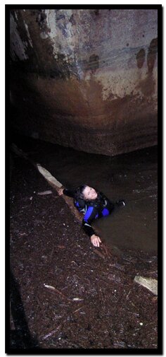
Rappelling skills are required to navigate through this slot canyon. Remember slot canyons can change dramatically in a short time due to flash floods and water levels in this canyon change. These directions are only a general reference. Be prepared for variations in the canyon. This is a magnificent slot canyon right in the heart of Zion Canyon. Technical canyoneers will be thrilled with the narrow slot canyon, pools of cold water to swim, exciting down climbs and odd-start rappels.
Trailhead: Echo Canyon - Begin at the Weeping Rock parking lot located about midway in Zion Echo Canyon - The slot canyon is impressive with many high wall sections and erie lighting. There are some areas blocked by boulders that will be difficult to climb up and down. A good climber should be part of the group. Be prepared for pools of neck high cold, stagnant water and pools that must be swam and may contain debris. The rappels and downclimbs should be 20' or less. The conditions in this slot canyon change. GPS Coordinates WGS84 Datum Leave East Rim Trail to enter into Echo Canyon: GPS coordinates are only references and may or may not be accurate. Do not rely on GPS coordinates as the sole method of navigation. Always have an accurate, detailed map at hand and have the proper map reading and navigation skills before setting out on any hike. Many of the hikes listed in this guide travel into canyons where a GPS has limited capabilities. Always check your position with a detailed map before dropping into a canyon. Beta: Coordinates and other trail and canyoneering information by Zion Park search and rescue veteran team member Bo Beck and zionnational-park.com author Mary Cisneros. To post trip reports, offer corrections, updates, or for more information please visit the Zion National Park Forum Suggested Gear: A sturdy pair of shoes are recommend to hike the trails in Zion National Park. Many quality shoes will help grip the rocks and prevent injury.
Zion National Park, UtahHistory of the Thunderbird |
East Zion Lodge Mileage from Stay in a hotel the heart of the parks, Mount Carmel Junction, and visit the treasures of the Southwest and Utah. Site Map Zion Hiking |
||||||||||||
|
This is my new favorite quote:
"I don't know who Mary Cisneros is, but I mean zionnational-park.com It's a better site than the NPS's anyway." Written by the authors of the book: Favorite Hikes in and around Zion National Park |
|||||||||||||


 In the winter and spring the water in the slot canyon is ice cold. This hike is best done in the summer when the water is warm. The stream that runs through Echo Canyon may dry up in the summer leaving behind pockets of water that may stagnate. The more water that is present the harder exploration will be.

 Canyon. Hike 2 miles up the
|
Zion History |
|---|
All rights reserved © Copyright Zion National-Park dot com
Do not use text, photos or maps without permission © Zion National-Park dot com
Contact the Author Mary Cisneros with any errors