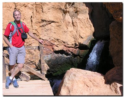
Cascade Falls
Cedar Mountain - Dixie National Forest
Markagunt is an Indian word meaning "highland of trees," which well describes this area since the Markagunt Plateau is one of the largest and highest plateaus in Southern Utah. The Markagunt High Plateau Scenic Byway, U-14 from Cedar City to its junction at US-89, is a popular recreation area known by most locals simply as Cedar Mountain. Traversing this section of Dixie National Forest, the largest national forest in Utah, is delightful. This beautiful scenic byway is lined with crowded groves of aspens, towering evergreens, ancient lava rock and a diverse display of wildflowers. Fall arrives early at this high elevation, chasing green from the aspens in October. In the forest, bright blue clean skies can be seen high above an almost endless sea of autumn leaves as they stretch as far as the eye can see. It's a treat to drive this scenic byway in September as air grows brisk and green leaves transform to red and yellow. Sitting at an elevation of 9,200 feet is picturesque Navajo Lake which can be seen from one of the pullouts near the road's summit. A quick stop lets visitors look down on the tree rimmed crystal blue body of water. Sink holes in the lake are an extremely important conduit in providing the source of water flowing from Cascade Falls and on to the North Fork of the Virgin River. Zion Narrows, the areas most famous '"trail" and one of the National Park Systems best trails, owes its existence to the flowing waters of the North Fork.
At a Glance Day Hike: Yes Distance: .45 miles one way or .9 miles round-trip mile. Average Hiking Time: Allow about an hour for a casual walk and time to enjoy the waterfall at the end of the trail. Equipment: Comfortable hiking shoes, hat, sun protection and water. Difficulty: This is an easy hike on a maintained trail that is ideal for kids. Holding young children's hands is suggested because of the steep terrain and kids can, and often do, stumble on uneven hiking paths such as this that are intermittently covered with loose rocks and other litter of nature. Sun Exposure: Full sun. Trail Usage: Moderate. Permits: Not required. Trail Conditions: This is a dirt path with slippery loose scree in sections and some wood bridges and steps on the short, steeper sections. The path should be easy for most people to walk along, however there have been injuries here so be careful and watch your step. Run-off can wash away the steps at times making the trail more difficult. Trailhead: Turn off U-14 onto Forest Road 053 at Navajo Lake, or turn at the Duck Creek Visitor Center, 2.5 miles east of the Navajo Lake Road. Follow the signs to Cascade Falls. Trailend: Same as trailhead Trail Access: In early spring or late fall, check to see that U-14 is open before attempting to drive to this trailhead. During this same time of the year there might be snowy conditions rendering dirt roads impassible. The trail to Cascade Falls is located on the southwest end of Cow Lake near the back of the large parking lot. Best Season: Summer
Elevation Change: 100 feet
Cascade Falls Trailhead:
From Cedar City: From Main Street in Cedar City, turn right on E. Center Street or U-14. Hit your odometer when you see the mileage sign on the right, then drive 24 miles passing the Navajo Lake Overlook, proceed another 3.7 miles, turning right at the Duck Creek Visitor Center on Forest Service Road 54.
From U-89: If you are coming from Long Valley Junction, which is the intersection of US-89 and U-14, drive 13 miles, then turn left at the Duck Creek Visitor Center onto Forest Service Road 54.
Duck Creek Visitor Center: Pass the visitor center, driving southwest on the dirt and gravel road. At 1.8 miles, Road 54 comes to an intersection. At this "Y" in the road, go left and travel alongside the normally dry Cow Lake for 1.6 miles to arrive at the Cascade Falls Trailhead.
Optional: The Cascade Falls Trail can also be accessed from the Navajo Lake access by turning south onto Navajo Lake Road, then traveling .3 miles to an intersection, steering left at the "Y" and looping around the ridge to arrive at the intersection at Cow Lake. Follow the road to the left alongside Cow Lake to arrive at the Cascade Falls Trailhead.
This round-trip hike is a little less than a mile long and it has few elevation changes. The route overlooks the southern edge of the Markagunt Plateau and ends at a rocky ledge with water tumbling down from a limestone cave. There is a wooden deck to stand on at the end and view the stream of water as it pours downward. It's not safe to get in the stream where it is slippery and the rocks are sharp.
Utah's Dixie National Forest: Cedar Mountain
Cedar Breaks National Monument is surrounded by Utah's Dixie National Forest. From Mt. Carmel Junction, drive north on US-89 to the junction with U-14. SR-14 is known as Cedar Mountain which is the scenic byway to travel to Cedar Breaks. Once on Cedar Mountain, travel through the beautiful forest, and then turn at the signed highway to Cedar Breaks - U-148. It's 22 miles from Mt. Carmel Junction to boundary of Dixie National Forest and 45 miles to Cedar Breaks.
Utah's Dixie National Forest: Red Canyon Red Canyon is a unique part of Dixie National Forest that is not only traveled through on the way to Bryce Canyon, but it has eroded hoodoos like Bryce Canyon and Cedar Breaks. It is found along U-12
Lodging and services are available on the gorgeous east side of Zion National Park, where guests are close to Zion National Park (12 miles), Bryce Canyon National Park (60 miles), Cedar Breaks National Monument (45 miles), Coral Pink Sand Dunes (12 miles), and the North Rim of the Grand Canyon (85 miles). It's where city traffic is absent and the skies are bright and clean.
GPS Coordinates WGS84 Datum
Duck Creek Visitor Center and Road to Cow Lake
37°30.947 N
112°41.944 W
Cascade Falls Trailhead
37°29.838 N
112°45.105 W
Cascade Falls Trailend
37°30.149 N
112°45.429 W
GPS coordinates are only references and may or may not be accurate. Do not rely on GPS coordinates as the sole method of navigation. Always have an accurate, detailed map at hand and have the proper map reading and navigation skills before setting out on any hike. Many of the hikes listed in this guide travel into canyons where a GPS has limited capabilities. Always check your position with a detailed map before dropping into a canyon.
Mileage from
Mt. Carmel Jct.
Zion National Park 12
Bryce Canyon 60
Grand Canyon 85
Cedar Breaks 45
Grand Staircase 9
Dixie Forest 22
Sand Dunes 11
Coyote Butte 57
Red Canyon 47
Tuweep 90
Stay in the heart of the parks, Mount Carmel Junction, and visit the treasures of the Southwest and Utah.
This is my new favorite quote:
"I don't know who Mary Cisneros is, but I mean zionnational-park.com
It's a better site than the NPS's anyway."
Written by the authors of the book: Favorite Hikes in and around Zion National Park
Contact Mary to report errors:


 Cascade Falls


 GPS Coordinates WGS84 Datum