|
|
 |
|||
|
Zion National Park Lodging Park Info Vacation Weather Photos Hike SR-9 Slots Backpack Camping |
||||

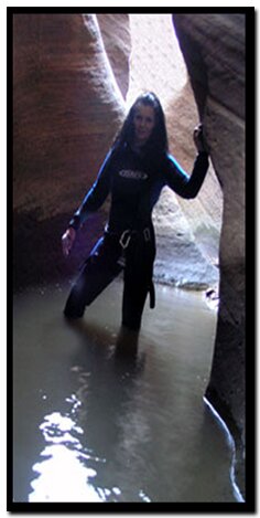
Zion: Keyhole CanyonKeyhole Canyon is a wonderful skinny slot canyon adventure with an easy and quick approach and exit. At a Glance Canyoneering: Never enter a technical canyon without the knowledge and skills needed to safely explore and return. Rappelling and downclimbing skills are required to navigate through Keyhole Canyon. Do not jump. Jumping in Zion's canyons have resulting in many broken bones.
Obstacle - The next challenge is a short 7' downclimb into another (possible) pool of water. Second Rappel - Continue another 20' downstream to the next anchor. This anchor is a glue-in type eyebolt anchor. This anchor will be used to rappel 20' into a bowl below. Walking across the bowl will afford another anchor opportunity which can be used to continue down another 20' on a low angle slab. There is the option to continue down this slab using the same glue-in anchor used to lower into the dish and then pull the rope once the low angle slab is negotiated. At the bottom of the slab the canyon becomes very deep, dark and convoluted. Obstacles and cold water swim - Shortly down canyon a somewhat awkward 8' downclimb is encountered providing the way deeper into the slot. A little further down-canyon brings a somewhat easier 10' downclimb which ends in a narrow section of swimming which may be somewhat long (100') and cold. Notice how the water in Keyhole gets increasingly colder while navigating through the canyon. Meandering down canyon for the next 150 yards brings a couple of wading pools and eventually the end of Keyhole Slot Canyon. The road is visible from the end of the canyon and once on the road the parking area of Keyhole is in view. Southern Utah Flash Flood info. Options - Jug Handle Arch is an hiking option.
Keyhole Slot CanyonParking at: Start of Keyhole: End of Keyhole Slot: Total Hike Length: .25 miles GPS coordinates are only references and may or may not be accurate. Do not rely on GPS coordinates as the sole method of navigation. Always have an accurate, detailed map at hand and have the proper map reading and navigation skills before setting out on any hike. Many of the hikes listed in this guide travel into canyons where a GPS has limited capabilities. Always check your position with a detailed map before dropping into a canyon. Beta: Coordinates and other trail and canyoneering information by Zion Park search and rescue veteran team member Bo Beck and zionnational-park.com author Mary Cisneros. To post trip reports, offer corrections, updates, or for more information please visit the Zion National Park Forum Suggested Gear: A sturdy pair of shoes are recommend to hike the trails in Zion National Park. Many quality shoes will help grip the rocks and prevent injury.
Zion National Park, UtahHistory of the Thunderbird |
East Zion Lodge Mileage from Stay in a hotel the heart of the parks, Mount Carmel Junction, and visit the treasures of the Southwest and Utah. Site Map Zion Hiking |
||||||||||||
|
This is my new favorite quote:
"I don't know who Mary Cisneros is, but I mean zionnational-park.com It's a better site than the NPS's anyway." Written by the authors of the book: Favorite Hikes in and around Zion National Park |
|||||||||||||

 Parking for Keyhole Canyon is 2 miles east of the small tunnel. A pullout large enough for 3-4 cars is located on the south side of SR- 9. The parking area is at the end of the Keyhole drainage entering from the north. Standing at the parking area and looking north through Keyhole, a glimpse of Jug Handle Arch in the Skyline is possible. Walk east on SR-9, passing Keyhole on the left (staying on the shoulder) for nearly .25 miles, bypassing a second drainage, entering from the left. Continue until another drainage is visible on the left. Enter the third drainage and walk up it (north) until the slickrock on the right side yields to travel. Continue up the slickrock bowl heading for the hoodoo on top. Once on top, travel to the right side of the hoodoo and seek the steep trail back down into the drainage on the north side of the saddle. At the bottom, turn left into the Keyhole drainage and work through the narrow sections until arriving at the first rappel from the large pine tree.


 GPS Coordinates WGS84 Datum
|
Zion History |
|---|
All rights reserved © Copyright Zion National-Park dot com
Do not use text, photos or maps without permission © Zion National-Park dot com
Contact the Author Mary Cisneros with any errors