|
|
 |
|||
|
Zion National Park Lodging Zion Info Vacation Weather Photos Hike Slot Canyons Backpack Camping |
||||

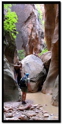
Orderville CanyonThe sport of canyoneering has gained momentum in Utah the past decade as intrepid explorers have been lured into dimly lit passages - caverns recessed into the earths thick crust. These channels form when flowing water detects a weakness in soft rock, then it gnaws away at the stone, creating twisted labyrinths and misshapen formations as it forces a path downward. Fantastic things have resulted - imagine if you can; vaulted cathedrals with towering arches born of sandstone. But it is not just the structural architecture that captivates us, it's also the intrinsic designs. Tiny whimsical waves, curves and whirls are splattered throughout long tunnels, and in many places, layers of hardened sand have been stripped away revealing slashes of color. These are not dark caves, but are fantastic slot canyons where light radiates from above resulting in an eerie incandescence that might just be the most seductive place in all of nature.
Call the Zion Canyon Visitors Center for weather conditions prior to the hike: (435) 772-3256. The Left Fork of North Creek is a slot canyon and like any slot canyon there is a very real danger from flash flooding. Do not hike this trail if it is raining. Remember a storm far off can trigger a flash flood. Flash flood danger is high.
Don't under estimate Orderville Canyon
Orderville Canyon -Walk in the waterway for a little over a half-mile, then follow the beaten path, heading left on top of the ridge, then drop into the canyon. The descent is about 175 feet. If water is flowing, look upstream to see the waterfall. Some canyoneers opt to rappel down this usually dry fall. Just over one mile into the hike, the canyon walls rise and move closer together.
Beyond the first obstacle there are several down climbs or short rappels to navigate along the way to the intersection with the Zion Narrows, including the following: Log ladder - There should be an anchor present for this 15 foot drop. Set up a rappel, hand-line or climb down. Logs - Logs in the waterway tend to be very slippery, so take care when going down them. Hand-lines or rappels are safer than trying to otherwise navigate them. Moki-Steps - Experienced climbers can make their way down the steps, but a rope is safer even for climbers, since this area tends to be mossy and slippery. Don't jump! Optional Bottom Entry - To avoid obstacles, hikers can explore a portion of the canyon from the bottom. A permit is not needed to do this. Take the shuttle to the Temple of Sinawava and take the casual stroll to the end of the Riverside Walk, then hike up stream, turning where Orderville Canyon enters on the right. A posted sign prohibits going farther than the "moki steps.' You don't need a permit to begin at the Temple of Sinawava and travel to the first obstacle within Orderville Canyon, just as you can explore the lower part of the Zion Narrows without a permit. Hiking in slot canyons presents a danger from flash flooding. Do not enter this or any canyon if it's raining. A storm far off can trigger a flash flood where you are. Be prepared for variations in the canyon since flash floods rearrange obstacles. Turn left off of the North Fork Road Trailhead: end of the washed out road First waterfall after dropping into canyon Beta: Coordinates and other trail and canyoneering information by Zion Park search and rescue veteran team member Bo Beck and zionnational-park.com author Mary Cisneros. Corrections: To post trip reports, offer corrections, updates, or for more information please visit the Suggested Equipment: A sturdy pair of shoes are recommend to hike a long distance in the Subway. Many quality shoes will help grip the rocks and prevent injury. Experienced hikers and Canyoneers often prefer a good quality rubber shoe like Sportiva Exum Ridge. Other prefer the Aqua Stealth Rubber Shoes or 5-10 Canyoneers but these are not as good for hiking. You might want to try wearing neoprene socks with them for added comfort if they are not already part of the shoe. Canyoneering Rope is required for this semi-technical canyon.
Zion National Park, UtahHistory of the Thunderbird |
East Zion Lodge Mileage from Stay in the heart of the parks, Mount Carmel Junction, and visit the treasures of the Southwest and Utah. Site Map Zion Hiking |
||||||||||||
|
This is my new favorite quote:
"I don't know who Mary Cisneros is, but I mean zionnational-park.com It's a better site than the NPS's anyway." Written by the authors of the book: Favorite Hikes in and around Zion National Park |
|||||||||||||


 GPS Coordinates WGS84 Datum
|
Zion History |
|---|
All rights reserved © Copyright Zion National-Park dot com
Do not use text, photos or maps without permission © Zion National-Park dot com
Contact the Author Mary Cisneros with any errors