 |
||||
|
Grand Canyon North Rim Toroweap Vacation Hike Backpack Rim2Rim Hwy-67 Photos Weather |
||||
Grand Canyon: North Kaibab Trail to Roaring SpringsPhoto Album: North Kaibab Trail Pictures
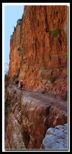
Supai Tunnel: Switchbacks twist and turn to Roaring Springs Canyon. A good day hike would end at the Supai Tunnel. At this point you have traveled 1.8 miles. The elevation is 6800'. At Supai Tunnel there is an unreliable fresh water source and restrooms. The Supai formation is the red rocks visible here and from the trail above. Roaring Springs: After passing through the small man-made Supai Tunnel, imposing cliffs come into view. Pinyon's and junipers become dominant. The Red Wall Bridge is a popular resting spot before heading down the cliff hugging trail ahead. The formations now are the Redwall Limestone, Muav Limestone, Bright Angel Shale and Tapeats Sandstone. Almost five miles down the trail is Roaring Springs. (4.7 miles) At this point you will have descended 3041'. The offshoot trail to Roaring Springs is .25 miles. There is fresh water and restrooms there. The elevation is 5200' at Roaring Springs.
North Kaibab Trail
The entire North Kaibab Trail distance, (one way) rim to river is 14.2 miles. Due to the extreme elevation changes this would not be done as a day hike. The North Kaibab trailhead shares the same parking area as the Ken Patrick and Uncle Jim trails. The trailhead is 2 miles north of the visitor center. The trail descends beneath the rim, through the forest, for the first 5 miles, leading to Roaring Springs. Roaring Springs is a waterfall created by water pouring from a muav cave into Bright Angel Creek. This creek is one of the Grand Canyon's largest tributaries and a home for beavers. Never plan to hike past Roaring Springs in one day. The following are points along the trail that can serve as a trail destination. Coconino Overlook .75 mile one way The North Kaibab Trail is the only North Rim trail leading into the inner canyon and can be done as a backpacking trip. Directions to the Grand Canyon North Rim - From Zion National Park, travel Highway 9 to Mt. Carmel Jct., then turn south on Highway 89 to Kanab. There is only one stop light in Kanab; this is where Hwy 89 changes to Highway 89A. Fredonia, Arizona is just a few miles away, across the Utah - Arizona border. Take Highway 89A to Jacob lake (36 miles), then take Highway 67 to the Grand Canyon North Rim park entrance. North Rim Grand Canyon Location - The North Rim of the Grand Canyon is 85 miles from Mount Carmel Junction, which is located on the east side of Zion National Park. Many who visit the National Parks of Southern Utah add the North Rim of the Grand Canyon to their travel plans and those visiting the North Rim of the Grand Canyon often visit Zion National Park.
Grand Canyon North Rim, ArizonaHistory of the Thunderbird |
East Zion Lodge Mileage from Stay in the heart of the parks, Mount Carmel Junction, and visit the treasures of the Southwest and Utah. Site Map Grand Canyon North Rim Grand Canyon Information Ranger Programs North Rim Trails Grand Canyon Maps |
||||||||||||
|
This is my new favorite quote:
"I don't know who Mary Cisneros is, but I mean zionnational-park.com It's a better site than the NPS's anyway." Written by the authors of the book: Favorite Hikes in and around Zion National Park Contact Mary to report errors: |
|||||||||||||
|
Zion History |
|---|
All rights reserved © Copyright Zion National-Park dot com
Do not use text, photos or maps without permission © Zion National-Park dot com
Contact the Author Mary Cisneros


 Coconino Overlook: The Coconino Overlook is only .75 miles and 500' below the rim. This area is a showcase of coconino sandstone where students are taken to see the fault and the many layers of rock that are visible here. The red rocks seen are the Supai formation. The Coconino Overlook gives a nice view of Roaring Springs Canyon.


