Lava Falls at a glance
Photo Album: Lava Falls Pictures Trail Map: Lava Falls Map Day hike: Yes, but camping at Lava Falls is allowed with a permit. Distance: 1.5 miles ( 2.41 km) one way Average hiking time: 8 hours - 2-4 hours down, 2-6 hours up. Difficulty: Strenuous and precarious. Falls are common, loose footing, bouldering. Permits: no, unless you want to backpack and camp down at the river Trail conditions: This trail is hot in the summer and is in full sun. Carrying enough water might be impossible for some. Consider hiking in the spring. Gloves are good protection from sharp rocks and cacti. Barrel Cactus are common along the route. Many hikers will find themselves using their hands often on the down hike to keep from falling on unstable footing. Cairns mark the route. Trailhead: The Lava Falls route and Vulcan's Throne route share the same trailhead. Trailend: Same as starting Trail access: 2.5 mile 4WD road that is impassible if water is in the usually dry Toroweap Lake. Elevation Change: 2540' in 1.5 miles. This is steep, do not underestimate the hike. Starting Elevation: 4180' at Lava Falls Trailhead Colorado River Elevation: 1640' Off the beaten path: yes Classic Park hike: Inner Canyon hike that is rarely traveled. Best season: Spring and Fall. Winter the daylight hours might be too short, summers are too hot. Water availability: No drinking water, but there is of course water at the river. Restrooms: Toroweap Campground or Toroweap Rim
Lava Falls Trailhead: From the Toroweap Rim go back down the road 2.8 miles and take the unmarked dirt 4WD road toward the usually dry Toroweap Lake and past the cinder cone of Vulcan's Throne. When there is excessive rain the lake bed can become muddy and the road will be impassible even with a 4WD.
There is no trail, but there is a route of sorts down to the Colorado River through a corridor. If you are looking for an enjoyable and scenic trail this is not it, but it does have its value. The hardcore hiker will be drawn to the challenge and the end point is the river. Do not underestimate the time needed to finish this hike since route finding is difficult and in the dark might be impossible. To add to this, the path is a jumbled mess of sharp and unsecured rock.
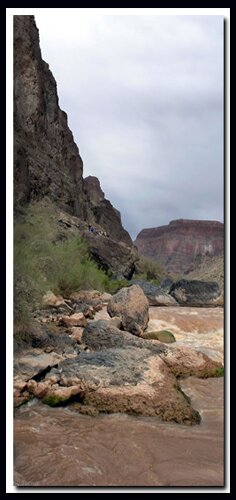
Make your way down the steep and unstable section, following the sparse display of cairns along the way. The first named section of the trail is called Vulture Valley. It's a bit unsettling to look up in this barren land and see the Turkey Vultures circle overhead as they like to do in this section of the route. At the bottom of Vulture Valley is a vertical step with a down climb. Climb up and over the large basalt ridge where the Colorado River and Prospect Valley are now visible. Toward the bottom of the route bright angel shale is visible. The roar of Lava Falls, although a low hum from the Toroweap Overlook, is now crystal clear. The falls are found .3 miles downstream from the routes end. In the Grand Canyon the Lava Falls section here forms rapids that are perhaps only second to the Crystal Rapid.
Directions to North Rim Grand Canyon: From Zion National Park, take on U-9 through the park to Mt. Carmel Jct. Turn south on US-89 to Kanab. There is only one stop light in Kanab; this is where US-89 changes to ALT 89. Fredonia, Arizona is 6 miles. In Fredonia take 89A to Jacob lake (36 miles), then take AZ 67 to the Grand Canyon North Rim park entrance.
Lava Falls rests below Toroweap Point at Tuweep in Western Grand Canyon
Lodging and services are available on the gorgeous east side of Zion National Park, where guests are close to Zion National Park (12 miles), Bryce Canyon National Park (60 miles), Cedar Breaks National Monument (45 miles), Coral Pink Sand Dunes (12 miles), and the North Rim of the Grand Canyon (85 miles). It's where city traffic is absent and the skies are bright and clean.
Best Trail Features: Trail leads to the Colorado River.
The Trail: This is the shortest and steepest rim to river hike in the Grand Canyon. Lava Falls was formed in 1939 by debris from Prospect Canyon. Watching the boats navigate the 13' drop is a high point of this hike.
Options: Hike up the cinder dome at the end of the hike rather than fighting the loose footing along the cairned route. if you are good at route finding you could even begin the hike this way.
Western Grand Canyon Permits
Permits can be obtained up to four months in advance from the NPS backcountry Information website. Permits are available in person six days in advance or less, and at the Pipe Spring National Monument which is 14 miles west of Fredonia, AZ. They can also be obtained at the Public Lands Information Center in St. George, UT at 345 E. Riverside Drive.
Tuweep Campground
Overnight use for the Tuweep area is only allowed at the Tuweep Campground. Picnic tables and composting toilets are provided. Reservation permits are required for all camping and overnight use at Tuweep Campground. Nine small campsites are available for one to six people with a maximum of two vehicles, including motorcycles. One large group campsite is for 7–11 people with a maximum of four vehicles, including motorcycles. There is no water available. Permits cannot be issued at Tuweep.
Mileage from
Mt. Carmel Jct.
Zion National Park 12
Bryce Canyon 60
Grand Canyon 85
Cedar Breaks 45
Grand Staircase 9
Dixie Forest 22
Sand Dunes 11
Coyote Butte 57
Red Canyon 47
Tuweep 90
Stay in the heart of the parks, Mount Carmel Junction, and visit the treasures of the Southwest and Utah.
This is my new favorite quote:
"I don't know who Mary Cisneros is, but I mean zionnational-park.com
It's a better site than the NPS's anyway."
Written by the authors of the book: Favorite Hikes in and around Zion National Park
Contact Mary to report errors:


 Lava Falls Trailhead: From the Toroweap Rim go back down the road 2.8 miles and take the unmarked dirt 4WD road toward the usually dry Toroweap Lake and past the cinder cone of Vulcan's Throne. When there is excessive rain the lake bed can become muddy and the road will be impassible even with a 4WD.

 Western Grand Canyon Permits