 |
||||
|
Grand Canyon North Rim Toroweap Vacation Hike Backpack Rim2Rim Hwy-67 Photos Weather |
||||
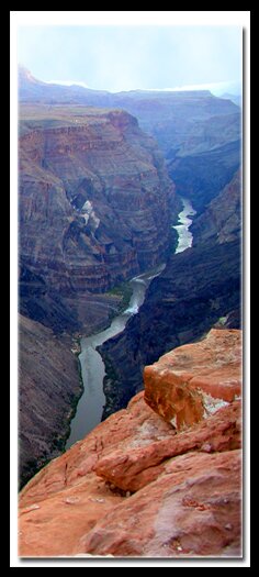
Grand Canyon GeologyThe big picture of the Grand Canyon's immense geology is revealed when leaving Jacob Lake, driving towards Kanab on Arizona Highway 89A, the stair steps of the Grand Staircase-Escalante National Monument are evident. The North Rim Grand Canyon is the bottom step of the Grand Staircase. The Grand Staircase extends 150 miles from bottom to top and rises 3500' in elevation. The bottom step is the oldest layer and this layer is the North Rim of the Grand Canyon. The youngest section is the pink cliffs that are usually considered to be: Bryce Canyon, Red Canyon and Cedar Breaks. Each of the main risers in the Grand Staircase are named for their colors: pink, gray, white, vermillion and chocolate. The Grand Staircase National Monument is huge, consisting of about two million acres of plateaus, mesas, buttes and slot canyons. Even though the North Rim of the Grand Canyon, Zion National Park, Bryce Canyon, Red Canyon and Cedar Breaks make up much of the geology of the Grand Staircase they are not within the boundaries of the monument. The geological wonders of the Grand Canyon do not end with the Grand Staircase, the park is known all over the world as a geological showplace and is one of the seven wonders of the world.
The Colorado River divided the Grand Canyon into four Plateaus - Millions of years ago water flowed through the mountains, starting as just a trickle and finally becoming a stream that carved its way through the many layers of soft rock. Erosion continued until the stream of water became the massive Colorado River. The force of the water drilled through the Kaibab Limestone, down to the Coconino Sandstone and Hermit Shale and on through the other layers until finally the oldest rocks were uncovered. The Colorado River divided the Grand Canyon into four plateaus. Today the Colorado River drains water from seven states. Directions to the Grand Canyon North Rim -From Zion National Park, travel SR-9 to Mt. Carmel Jct., then turn south on US-89 to Kanab. There is only one stop light in Kanab; this is where US-89 changes to SR-89A. Fredonia, Arizona is just a few miles away, across the Utah - Arizona border. Take SR-89A to Jacob lake (36 miles), then take SR-67 to the Grand Canyon North Rim park entrance. North Rim Grand Canyon Location - The North Rim of the Grand Canyon is 85 miles from Mount Carmel Junction, which is located on the east side of Zion National Park. Many who visit the National Parks of Southern Utah add the North Rim of the Grand Canyon to their travel plans and those visiting the North Rim of the Grand Canyon often visit Zion National Park.
Grand Canyon North Rim, ArizonaHistory of the Thunderbird |
East Zion Lodge Mileage from Stay in the heart of the parks, Mount Carmel Junction, and visit the treasures of the Southwest and Utah. Site Map Grand Canyon North Rim Grand Canyon Information Ranger Programs North Rim Trails |
||||||||||||
|
This is my new favorite quote:
"I don't know who Mary Cisneros is, but I mean zionnational-park.com It's a better site than the NPS's anyway." Written by the authors of the book: Favorite Hikes in and around Zion National Park Contact Mary to report errors: |
|||||||||||||
|
Zion History |
|---|
All rights reserved © Copyright Zion National-Park dot com
Do not use text, photos or maps without permission © Zion National-Park dot com
Contact the Author Mary Cisneros


