|
|
 |
|||
|
Grand Canyon North Rim Toroweap Vacation Hike Backpack Rim2Rim Hwy-67 Photos Weather |
||||

Grand Canyon's Esplanade
|
|||||||||||||||||||
 Esplanade via the Bill Hall Trailhead
Grand Canyon North Rim Road MapDirections to North Rim Grand Canyon: From Zion National Park, take on U-9 through the park to Mt. Carmel Jct. Turn south on US-89 to Kanab. There is only one stop light in Kanab; this is where US-89 changes to ALT 89. Fredonia, Arizona is 6 miles. In Fredonia take 89A to Jacob lake (36 miles), then take AZ 67 to the Grand Canyon North Rim park entrance. Winter Road Conditions and

|
|
|||
|
|
||||

Starting at the Monument Point Trailhead early in the morning affords cooler temperatures throughout the next 5 hour, 5.35 mile hike. Initially the trail descends briefly, then begins to gradually climb the ridge to the west, toward Monument Point. After .75 miles, the trail will drop off abruptly to the left and begin the descent toward the Esplanade. As the trail descends, it bears to the west and will eventually bring you to the western slopes of Monument Point and well below the point itself. Looking to the south is a magnificent view of the Esplanade and Bridgers Knoll. To the southeast is Tapeats Creek far below and to the west are glimpses of Deer Creek Canyon. Looking to the south a small section of the Colorado River is also visible.
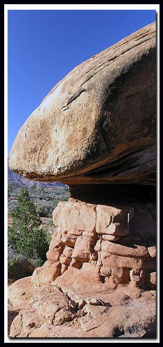
The Esplanade below is absolutely stunning with expanses of slickrock, hoodoos and weather-cut canyons. Traversing to the west for .5 miles will soon yield a weakness in the limestone cliff and a steep descent, once again, begins. There is one short rock section that may require the use of rope to assist unsure hikers or to lower packs. Many switchbacks later, the scree begins fanning at a much lower angle and the trail begins its final descent to the slickrock below. Soon the intersection of the Indian Hollow Trail joins on the right and the hiking will shortly become a joy of contouring the massive slickrock deck to the south and west aiming towards the descent trail into Surprise Valley. The travel for the next 3 miles is enjoyable as the hiking is quite level and on solid rock most of the time. There are many opportunities to make camp. Remember to stay near the trail and do not disturb the delicate cryptobiotic soil when choosing a campsite.
Camping on the Esplanade - Camp at least 100' from water. Campfires are not allowed in the backcountry. Leave the ground undisturbed where you camp and do not trample cryptobiotic soil when leaving the trail to camp.
Day 2 - Esplanade to the Bill Hall Trailhead - Leave camp early in the morning so the ascent back to Monument Point will be done during cooler temperatures of the day. Hiking back through the slickrock of the Esplanade toward Monument Point gives a totally new perspective from the hike coming down just two days previous.
Options: Option - Thunder River
Monument Point from Fredonia Arizona - map
In the Town of Fredonia Arizona, from the intersection of Highways 389 and 89, travel south on Highway 89 toward Jacob Lake and the North Rim of the Grand Canyon for 1.5 miles and find the road FR 22 (forest road) that turns off to the right near a couple of buildings. This road (forest service 22) is a paved 2 lane highway for the next 21.5 miles. At 21.5 miles the road becomes dirt and gravel but remains in good condition. It might become impassable when wet, however these roads dry out quickly and can usually be traveled the next morning even after a hard rain. Continue on Forest Service 22, bypassing several intersections and signage that directs towards different vistas. At mile 28 the Big Springs Field Ranger station and spring will be bypassed on drivers left. Gaining elevation, travel farther south results in vegetation change from juniper and pinon pine to a ponderosa and aspen forest. At mile 30 (another intersection shows the direction to the Kanab Creek Wilderness), continue south on Forest Road 22 towards the vistas. At mile 33 (from the intersection at 89 and 22), turn right onto Forest Road 425  toward Crazy Jug Point 12 miles and Monument Point 13 miles. The road still remains good, but gets narrower and winds from the ridge-top to valleys the farther west traveled. Camping during the next several miles is sparse, however camping opportunities become abundant soon. At mile 41, another intersection, continuing straight on Forest Road 425 four more miles to Crazy Jug Point and 5 more miles to the Monument Point Trailhead. At the 43 mile point there is a "Y" in the road next to a corral, Forest Road 292 bears right and goes toward Monument Point. At mile 43.3 miles, don't take 272 at the "Y", continue right to Monument Point. At 44.5 miles is an intersection, left on 292A will go to Crazy Jug Point in just .5 miles or continue straight another 2 miles to arrive at Monument Point Trailhead.
| GPS Coordinates WGS84 Datum | ||
| Monument Point Trailhead 36 26.0690N 112 25.7670W |
Bill Hall Trail Begins Descent 36 25.8570N 112 26.3770W |
|
|
|
Grand Canyon North Rim, Arizona
History of the Thunderbird

East Zion Lodge
Vacation House
Group Lodging
East Zion Golf
East Zion RV Park
Vacation Packages
Family Reunion
Bus Tours
Business Retreat
Mileage from
Mt. Carmel Jct.
Zion National Park 12
Bryce Canyon 60
Grand Canyon 85
Cedar Breaks 45
Grand Staircase 9
Dixie Forest 22
Sand Dunes 11
Coyote Butte 57
Red Canyon 47
Tuweep 90
Stay in the heart of the parks, Mount Carmel Junction, and visit the treasures of the Southwest and Utah.
Site Map
Site Map II
Site Map III
Grand Canyon
North Rim
North Rim Grand Canyon Information
Ranger Programs
Ancient History
Fees & Passes
Kid Activities
Geology
History
Fauna
Flora
North Rim Trails
North Kaibab Trail
Ken Patrick Trail
Cape Royal Trail
Uncle Jim Trail
Thunder River
Widforss Trail
Point Sublime
Esplanade
Lava Falls
Grand Canyon Maps
Northern Arizona Map
North Rim Trail Map
Directions
South Canyon
North Rim
Toroweap
"I don't know who Mary Cisneros is, but I mean zionnational-park.com
It's a better site than the NPS's anyway."
Written by the authors of the book: Favorite Hikes in and around Zion National Park
Contact Mary to report errors:
|
Zion History |
|---|
All rights reserved © Copyright Zion National-Park dot com
Do not use text, photos or maps without permission © Zion National-Park dot com
Contact the Author Mary Cisneros