border

Deer Creek Trail

Book: Favorites hike in and around Zion National Park - including Grand CanyonPhoto Album: Deer Creek Pictures
Trail Map: Deer Creek Map
Day Hike: Not recommended. This trail is best done as a two or three day hike. Do not attempt to hike down to Deer Creek and back in one day
Average Hiking Time: 3 days. 5 Hours From Monument Point Trailhead to Campsite on the Esplanade. 6 Hours From Campsite on the Esplanade to the Trailhead at Monument Point.
Equipment: Sleeping bag, pad, tent, rugged hiking shoes, extra socks, clothing, jacket, rain gear, hat, first aid kit with blister treatment and ibuprofen, personal hygiene accessories, wag bags, stove and fuel, pot for heating water, freeze dried foods, electrolyte replacement Powder, 1.5 gallon water containers for each person, water filter or purification treatment, map, compass, zip locks for trash and toilet paper carryout. Hiking poles can be useful. Keep weight as low as possible.
Difficulty: Strenuous. Skills are needed for navigating remote backcountry areas and a small scrambling section. The descent from the rim (and the climb back up again) from the trailhead to Deer Creek is beyond what most backpackers are comfortable with.
Permits: Yes, for camping. A permit can be acquired by logging onto www.nps.gov, go to the Grand Canyon directory and look for backcountry permit procedures. A downloadable, faxable permit registration will need to be completed; including the dates you anticipate camping, where you will be entering the Grand Canyon and where you plan to camp. At the time of this report, a permit request is $10 and $5/person per night while camping in the Grand Canyon National Park. There is no guarantee that you will get the requested dates that are submitted, so if there is some flexibility in your schedule then you may wish to submit second date choices.
Trail Conditions: This trail is hot in the summer. Consider hiking in the spring and fall.
Trailhead: Bill Hall Trailhead - North Rim.
Trailend: Same as trailhead.
Trail Access: The roads in the Kaibab Forest are good, but they are dirt roads and can be impassible when wet, have fresh snow on them or there is melting snow. The roads tend to dry out quickly even after a heavy rain storm and can usually be traveled the next day.
Elevation: Highest Elevation near Monument Point- 7166'
Elevation: Rim of the Esplanade - 5000'
Elevation: 1920' Deer Creek
Off the Beaten Path: Yes
Classic Hike: No
Best Season: Spring and Fall.
Water Availability: Deer Creek, but purify before use.
Restrooms: None. Pack it in, pack it out including toilet paper. Use 6" cat holes and stay away from any water source.

Grand Canyon Canyon Map Coral Pink Sand Dunes Map Grand Staircase-Escalante Map Bryce Canyon National Park Grand Canyon National Park, Arizona - North Rim Map Red Canyon, Dixie National Forest, Utah Lodging: Zion National Park Zion National Park Cedar Breks National Monument, Utah Dixie National Forest: Cedar Mountain Zion National Park Map Coral Pink Sand Dunes Map Zion National Park Lodging Cedar Breaks and Dixie National Forest Map Bryce Canyon and Red Canyon Map Grand Staircase-Escalante Map Zion National Park Map Coral Pink Sand Dunes Map Zion National Park Lodging Cedar Breaks and Dixie National Forest Map Grand Staircase-Escalante Map Bryce Canyon National Park Zion National Park Map Coral Pink Sand Dunes Map Zion National Park Lodging Cedar Breaks and Dixie National Forest Map Bryce Canyon and Red Canyon Map Grand Staircase-Escalante Map Zion National Park Map Coral Pink Sand Dunes Map Zion National Park Lodging Cedar Breaks and Dixie National Forest Map Bryce Canyon and Red Canyon Map Grand Staircase-Escalante Map Coral Pink Sand Dunes Map Grand Staircase-Escalante Map Bryce Canyon National Park Grand Canyon National Park, Arizona - North Rim Map Red Canyon, Dixie National Forest, Utah Lodging: Zion National Park Zion National Park Cedar Breks National Monument, Utah Dixie National Forest: Cedar Mountain Zion National Park Map Coral Pink Sand Dunes Map Zion National Park Lodging Cedar Breaks and Dixie National Forest Map Bryce Canyon and Red Canyon Map Grand Staircase-Escalante Map Zion National Park Map Coral Pink Sand Dunes Map Zion National Park Lodging Cedar Breaks and Dixie National Forest Map Grand Staircase-Escalante Map Bryce Canyon National Park Zion National Park Map Coral Pink Sand Dunes Map Zion National Park Lodging Cedar Breaks and Dixie National Forest Map Bryce Canyon and Red Canyon Map Grand Staircase-Escalante Map Zion National Park Map Coral Pink Sand Dunes Map Zion National Park Lodging Cedar Breaks and Dixie National Forest Map Bryce Canyon and Red Canyon Map Grand Staircase-Escalante Map Zion National Park Map Coral Pink Sand Dunes Map Zion National Park Lodging Cedar Breaks and Dixie National Forest Map Bryce Canyon and Red Canyon Map Grand Staircase-Escalante Map Coral Pink Sand Dunes Map Grand Staircase-Escalante Map Bryce Canyon National Park Grand Canyon National Park, Arizona - North Rim Map Red Canyon, Dixie National Forest, Utah Lodging: Zion National Park Zion National Park Cedar Breks National Monument, Utah Dixie National Forest: Cedar Mountain Zion National Park Map Coral Pink Sand Dunes Map Zion National Park Lodging Cedar Breaks and Dixie National Forest Map Bryce Canyon and Red Canyon Map Grand Staircase-Escalante Map Zion National Park Map Coral Pink Sand Dunes Map Zion National Park Lodging Cedar Breaks and Dixie National Forest Map Grand Staircase-Escalante Map Bryce Canyon National Park Zion National Park Map Coral Pink Sand Dunes Map Zion National Park Lodging Cedar Breaks and Dixie National Forest Map Bryce Canyon and Red Canyon Map Grand Staircase-Escalante Map Zion National Park Map Coral Pink Sand Dunes Map Zion National Park Lodging Cedar Breaks and Dixie National Forest Map Bryce Canyon and Red Canyon Map Grand Staircase-Escalante Map Coral Pink Sand Dunes Map Grand Staircase-Escalante Map Bryce Canyon National Park Grand Canyon National Park, Arizona - North Rim Map Red Canyon, Dixie National Forest, Utah Lodging: Zion National Park Zion National Park Cedar Breks National Monument, Utah Dixie National Forest: Cedar Mountain Zion National Park Map Coral Pink Sand Dunes Map Zion National Park Lodging Cedar Breaks and Dixie National Forest Map Bryce Canyon and Red Canyon Map Grand Staircase-Escalante Map Zion National Park Map Coral Pink Sand Dunes Map Zion National Park Lodging Cedar Breaks and Dixie National Forest Map Grand Staircase-Escalante Map Bryce Canyon National Park Zion National Park Map Coral Pink Sand Dunes Map Zion National Park Lodging Cedar Breaks and Dixie National Forest Map Bryce Canyon and Red Canyon Map Grand Staircase-Escalante Map Zion National Park Map Coral Pink Sand Dunes Map Zion National Park Lodging Cedar Breaks and Dixie National Forest Map Bryce Canyon and Red Canyon Map Grand Staircase-Escalante Map Zion National Park Map Coral Pink Sand Dunes Map Zion National Park Lodging Cedar Breaks and Dixie National Forest Map Bryce Canyon and Red Canyon Map Grand Staircase-Escalante Map Zion National Park Map Coral Pink Sand Dunes Map Zion National Park Lodging Cedar Breaks and Dixie National Forest Map Bryce Canyon and Red Canyon Map Grand Staircase-Escalante Map Zion National Park Map Coral Pink Sand Dunes Map Zion National Park Lodging Cedar Breaks and Dixie National Forest Map Bryce Canyon and Red Canyon Map Grand Staircase-Escalante Map Coral Pink Sand Dunes Map Grand Staircase-Escalante Map Bryce Canyon National Park Grand Canyon National Park, Arizona - North Rim Map Red Canyon, Dixie National Forest, Utah Lodging: Zion National Park Zion National Park Cedar Breks National Monument, Utah Dixie National Forest: Cedar Mountain Zion National Park Map Coral Pink Sand Dunes Map Zion National Park Lodging Cedar Breaks and Dixie National Forest Map Bryce Canyon and Red Canyon Map Grand Staircase-Escalante Map Zion National Park Map Coral Pink Sand Dunes Map Zion National Park Lodging Cedar Breaks and Dixie National Forest Map Grand Staircase-Escalante Map Bryce Canyon National Park Zion National Park Map Coral Pink Sand Dunes Map Zion National Park Lodging Cedar Breaks and Dixie National Forest Map Bryce Canyon and Red Canyon Map Grand Staircase-Escalante Map Zion National Park Map Coral Pink Sand Dunes Map Zion National Park Lodging Cedar Breaks and Dixie National Forest Map Bryce Canyon and Red Canyon Map Grand Staircase-Escalante Map Coral Pink Sand Dunes Map Grand Staircase-Escalante Map Bryce Canyon National Park Grand Canyon National Park, Arizona - North Rim Map Red Canyon, Dixie National Forest, Utah Lodging: Zion National Park Zion National Park Cedar Breks National Monument, Utah Dixie National Forest: Cedar Mountain Zion National Park Map Coral Pink Sand Dunes Map Zion National Park Lodging Cedar Breaks and Dixie National Forest Map Bryce Canyon and Red Canyon Map Grand Staircase-Escalante Map Zion National Park Map Coral Pink Sand Dunes Map Zion National Park Lodging Cedar Breaks and Dixie National Forest Map Grand Staircase-Escalante Map Bryce Canyon National Park Zion National Park Map Coral Pink Sand Dunes Map Zion National Park Lodging Cedar Breaks and Dixie National Forest Map Bryce Canyon and Red Canyon Map Grand Staircase-Escalante Map Zion National Park Map Coral Pink Sand Dunes Map Zion National Park Lodging Cedar Breaks and Dixie National Forest Map Bryce Canyon and Red Canyon Map Grand Staircase-Escalante Map Zion National Park Map Coral Pink Sand Dunes Map Zion National Park Lodging Cedar Breaks and Dixie National Forest Map Bryce Canyon and Red Canyon Map Grand Staircase-Escalante Map Coral Pink Sand Dunes Map Grand Staircase-Escalante Map Bryce Canyon National Park Grand Canyon National Park, Arizona - North Rim Map Red Canyon, Dixie National Forest, Utah Lodging: Zion National Park Zion National Park Cedar Breks National Monument, Utah Dixie National Forest: Cedar Mountain Zion National Park Map Coral Pink Sand Dunes Map Zion National Park Lodging Cedar Breaks and Dixie National Forest Map Bryce Canyon and Red Canyon Map Grand Staircase-Escalante Map Zion National Park Map Coral Pink Sand Dunes Map Zion National Park Lodging Cedar Breaks and Dixie National Forest Map Grand Staircase-Escalante Map Bryce Canyon National Park Zion National Park Map Coral Pink Sand Dunes Map Zion National Park Lodging Cedar Breaks and Dixie National Forest Map Bryce Canyon and Red Canyon Map Grand Staircase-Escalante Map Zion National Park Map Coral Pink Sand Dunes Map Zion National Park Lodging Cedar Breaks and Dixie National Forest Map Bryce Canyon and Red Canyon Map Grand Staircase-Escalante Map Coral Pink Sand Dunes Map Grand Staircase-Escalante Map Bryce Canyon National Park Grand Canyon National Park, Arizona - North Rim Map Red Canyon, Dixie National Forest, Utah Lodging: Zion National Park Zion National Park Cedar Breks National Monument, Utah Dixie National Forest: Cedar Mountain Zion National Park Map Coral Pink Sand Dunes Map Zion National Park Lodging Cedar Breaks and Dixie National Forest Map Bryce Canyon and Red Canyon Map Grand Staircase-Escalante Map Zion National Park Map Coral Pink Sand Dunes Map Zion National Park Lodging Cedar Breaks and Dixie National Forest Map Grand Staircase-Escalante Map Bryce Canyon National Park Zion National Park Map Coral Pink Sand Dunes Map Zion National Park Lodging Cedar Breaks and Dixie National Forest Map Bryce Canyon and Red Canyon Map Grand Staircase-Escalante Map Zion National Park Map Coral Pink Sand Dunes Map Zion National Park Lodging Cedar Breaks and Dixie National Forest Map Bryce Canyon and Red Canyon Map Grand Staircase-Escalante Map Zion National Park Map Coral Pink Sand Dunes Map Zion National Park Lodging Cedar Breaks and Dixie National Forest Map Bryce Canyon and Red Canyon Map Grand Staircase-Escalante Map Zion National Park Map Coral Pink Sand Dunes Map Zion National Park Lodging Cedar Breaks and Dixie National Forest Map Bryce Canyon and Red Canyon Map Grand Staircase-Escalante Map Zion National Park Map Coral Pink Sand Dunes Map Zion National Park Lodging Cedar Breaks and Dixie National Forest Map Bryce Canyon and Red Canyon Map Grand Staircase-Escalante Map Zion National Park Map Coral Pink Sand Dunes Map Zion National Park Lodging Cedar Breaks and Dixie National Forest Map Bryce Canyon and Red Canyon Map Grand Staircase-Escalante Map Zion National Park Map Coral Pink Sand Dunes Map Zion National Park Lodging Cedar Breaks and Dixie National Forest Map Bryce Canyon and Red Canyon Map Grand Staircase-Escalante Map Zion National Park Map Coral Pink Sand Dunes Map Zion National Park Lodging Cedar Breaks and Dixie National Forest Map Bryce Canyon and Red Canyon Map Grand Staircase-Escalante Map Deer Creek Trail via the Bill Hall Trailhead

This trail description begins at the Monument Point Trailhead on the North Rim and follows the Bill Hall Trail onto the Esplanade. The descent is steep and in full sunlight and more than likely there will be no water available at your campsite on the Esplanade. Make sure that you are carrying enough water for the first day of hiking, cooking at camp, and then enough left over for a fairly strenuous, but downhill hike to Thunder Springs the following day.

Day 1 - Monument Point to the Esplanade

Starting at the Monument Point Trailhead early in the morning affords cooler temperatures throughout the next 5 hour, 5.35 mile hike. Initially, the trail descends briefly then begins to climb, gradually, the ridge to the west toward Monument Point. After .75 miles, the trail will drop off abruptly to the left and begin the descent toward the Esplanade. As the trail descends it also bears to the west and will eventually bring you to the western slopes of Monument Point, well below the point itself. Looking south is a magnificent view of the Esplanade and Bridgers Knoll. To the southeast is Tapeats Creek far below and to the west are glimpses of Deer Creek Canyon. Looking to the south a small section of the Colorado River is also visible. The Esplanade below is absolutely stunning with expanses of slickrock, hoodoos and weather cut canyons. Traversing to the west for .5 miles will soon yield a weakness in the limestone cliff and a steep descent once again begins. There is one solid rock section that may require the use of rope to assist unsure hikers or to lower packs, but it is a short section. Many switchbacks, later the scree begins fanning at a much lower angle and the trail begins its final descent to the slickrock below. Soon the intersection of the Indian Hollow Trail joins from the right and the hiking will shortly become a joy of contouring the massive slickrock deck to the south and west aiming towards the descent trail into Surprise Valley. The travel for the next 3 miles is enjoyable as the hiking is quite level and on solid rock most of the time. There are many opportunities to make camp, however many opt to camp just above the descent into Surprise Valley in order to shorten the hike for day two. Remember to stay near the trail and do not disturb the delicate cryptobiotic soil when choosing a campsite.

Grand Canyon North Rim Road Map

Directions to North Rim Grand Canyon: From Zion National Park, take on U-9 through the park to Mt. Carmel Jct. Turn south on US-89 to Kanab. There is only one stop light in Kanab; this is where US-89 changes to ALT 89. Fredonia, Arizona is 6 miles. In Fredonia take 89A to Jacob lake (36 miles), then take AZ 67 to the Grand Canyon North Rim park entrance.

Winter Road Conditions and
Highway 67 Road Closures


Zion National Park Maps
 
Grand Canyon's Deer Creek

Hike through the esplanade to Deer Creek and to the Colorado River


Lodging Zion National Park
Lodging Zion National ParkLodging and services are available on the gorgeous east side of Zion National Park, where guests are close to Zion National Park (12 miles), Bryce Canyon National Park (60 miles), Cedar Breaks National Monument (45 miles), Coral Pink Sand Dunes (12 miles), and the North Rim of the Grand Canyon (85 miles). It's where city traffic is absent and the skies are bright and clean.


please link to meCamping on the Esplanade - Camp at least 100' from water. Campfires are not allowed in the backcountry. Leave the ground undisturbed where you camp and do not trample cryptobiotic soil when leaving the trail to camp.

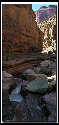
Day Two - Deer Creek

The day hike from camp on the Esplanade to Deer Creek promises another full day of adventure and exploring. The descent to Surprise Valley is very steep and loose in places and requires careful travel. Starting early in the morning allows for cooler temperatures during the descent. The trail down from the Esplanade, as well as the trail west through Surprise Valley, offers very little opportunity for shade.

Leave a gallon of water in the shade at your campsite. Carry 2 liters of water per person for the hike down, and take an empty 6 liter dromedary to be filled at Deer Creek. The extra weight (12 Lbs.) of the 6 liters will be substantial on the way back up to camp, but will provide enough water for 2 people for cooking that night and enough water to start with full containers on the hike out the following day.

After descending 1400' and a little over 1 mile of hiking, the upper intersection to Deer Creek is reached and marked by a cairn. Turn right here and begin the trek across Surprise Valley until it abruptly drops down toward Deer Creek, passing Deer Creek Spring and the Throne Room on the way down. Shortly the trail reaches Deer Creek Drainage below and the trail travels toward the Colorado River. Deer Creek soon becomes a narrow slot canyon as the path skirts on the right and the narrow slot disappears far below. The last jaunt to the river traverses the hillside and then dives steeply ending at the wondrous 200' high Deer Creek Falls at rivers edge. Enjoy a bath, converse with other hikers and "river runners" on the beach, then prepare for the long uphill trek back to the Esplanade and camp.

Day 3 - Esplanade to the Bill Hall Trailhead

Leave camp early in the morning so the ascent back to Monument Point will be done during cooler temperatures of the day. Hiking back through the slickrock of the Esplanade toward Monument Point gives a totally new perspective from the hike coming down just two days previous.

Option - Camp at Surprise Valley for shorter day hikes, but a longer backpack out on the final day.

Option - Stay another day and hike to Thunder River and Tapeats Creek and the Colorado River or stay on more level ground and explore around the Esplanade.

Monument Point from Fredonia Arizona - map

In the Town of Fredonia Arizona, from the intersection of Highways 389 and 89, travel south on Highway 89 toward Jacob Lake and the North Rim of the Grand Canyon for 1.5 miles and find the road FR 22 (forest road) that turns off to the right near a couple of buildings. This road (forest service 22) is a paved 2 lane highway for the next 21.5 miles. At 21.5 miles the road becomes dirt and gravel but remains in good condition. The road might become impassable when wet however, these roads dry out quickly and can usually be traveled the next morning even after a hard rain. Continue on Forest Service 22, bypassing several intersections and signage that directs towards different vistas. At mile 28 the Big Springs Field Ranger station and spring will be bypassed on drivers left. Gaining elevation, travel farther south results in vegetation change from juniper and pinon pine to a ponderosa and aspen forest. At mile 30 (another intersection shows the direction to the Kanab Creek Wilderness), continue south on Forest Road 22 towards the vistas. At mile 33 (from the intersection at 89 and 22), turn right onto Forest Road 425 toward Crazy Jug Point 12 miles and Monument Point 13 miles. The road still remains good, but gets narrower and winds from the ridge-top to valleys the farther west traveled. Camping during the next several miles is sparse, however camping opportunities become abundant soon. At mile 41, another intersection, continuing straight on Forest Road 425 four more miles to Crazy Jug Point and 5 more miles to the Monument Point Trailhead. At 43 miles there is a "Y" in the road next to a corral, Forest Road 292 zion National Park Canyoneeringbears right and goes toward Monument Point. At mile 43.3 miles, don't take 272 at the "Y", continue right to Monument Point. At 44.5 miles is an intersection, left on 292A will go to Crazy Jug Point in just .5 miles or continue straight another 2 miles to arrive at Monument Point Trailhead.

GPS Coordinates WGS84 Datum

Monument Point Trailhead:
36 26.0690N
112 25.7670W

Bill Hall Trail Begins Descent:
36 25.8570N
112 26.3770W

Descent from Esplanade into Surprise Valley Begins:
36 24.5432N
112 28.3344W

Share


Web Southwest Parks


Grand Canyon North Rim, Arizona


History of the Thunderbird

Best Western
East Zion Lodge

Reservations
1.888.848.6358

Zion Park Lodging

Zion National Park Lodging

East Zion Lodge
Vacation House
Group Lodging
East Zion Golf
East Zion RV Park
Vacation Packages
Family Reunion
Bus Tours
Business Retreat

Mileage from
Mt. Carmel Jct.

Zion National Park 12
Bryce Canyon 60
Grand Canyon 85
Cedar Breaks 45
Grand Staircase 9
Dixie Forest 22
Sand Dunes 11
Coyote Butte 57
Red Canyon 47
Tuweep 90

Stay in the heart of the parks, Mount Carmel Junction, and visit the treasures of the Southwest and Utah.

Site Map
Site Map II
Site Map III

Nampaweap Petroglyphs

Grand Canyon
North Rim


North Rim Grand Canyon Information

Ranger Programs
Ancient History
Fees & Passes
Kid Activities
Geology
History
Fauna
Flora

North Rim Trails
North Kaibab Trail
Ken Patrick Trail
Cape Royal Trail
Uncle Jim Trail
Thunder River
Widforss Trail
Point Sublime
Esplanade
Lava Falls

Grand Canyon Maps
Northern Arizona Map
North Rim Trail Map

Directions
South Canyon
North Rim
Toroweap

This is my new favorite quote:
"I don't know who Mary Cisneros is, but I mean zionnational-park.com
It's a better site than the NPS's anyway."
Written by the authors of the book: Favorite Hikes in and around Zion National Park
Contact Mary to report errors:
 
border

Zion History
Zion Landmarks
Zion Geology
Zion Geology II
Zion Geology III
Zion Fauna

Zion Rock Art

Disclaimer & Privacy Policy
All rights reserved © Copyright Zion National-Park  dot com
Do not use text, photos or maps without permission © Zion National-Park dot com
Contact the Author Mary Cisneros
Zion Backcountry Topo Map - Trail Interactive Zion National Park Map - Overview of Zion Zion National Park Road Map Zion Tunnel and Shuttle Information