|
|

|
|||
|
Zion National Park Lodging Zion Info Vacation Weather Photos Hike Slot Canyons Backpack Camping |
||||

|
||||||||||||||

Directions to Zion National ParkFrom the North: Travel I-15 south, past Beaver. exit on Hwy 20. Follow US-89 to Mount Carmel Junction. Take SR-9 to Zion's east entrance.
|
|
|||
|
|
||||


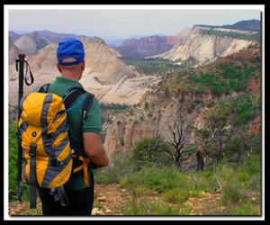
 West Rim Trail Directions - From the Grotto picnic area, cross the road and walk over the foot-bridge to the West Rim - Angels Landing trailhead. Climb the sun drenched switchbacks up the steep path as they wind back and forth takers hikers higher and higher. Eyes gaze upon the beauty of Zion Canyon as they follow the Virgin River flowing at the base of the trail.
Refrigerator Canyon - This is the part of the trail where hikers get a slight reprieve from the constant, steep grade of the West Rim Trail and the heat of the full sun. Towering canyon walls shade and cool the trail in this all too brief section.
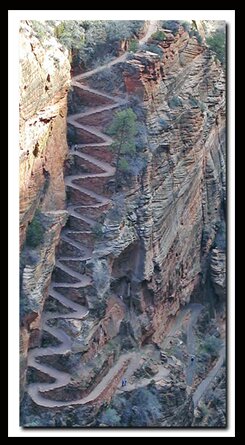
Walter's Wiggles - Squiggle the wiggles, as they ascend the steep twenty-one sharp switchbacks from the floor of Refrigerator Canyon to Scout Lookout. Few make it up this part of the route without stopping for a couple of breathers. The Walter's Wiggles section was named after the first superintendent of Zion National Park, who in 1924-1925, helped engineer the twenty-one switchbacks.
Scout Lookout and Angels Landing - This is the 2-mile mark and the saddle at the junction of the Angels Landing and West Rim Trails. The views of Zion Canyon here are even more impressive than they were lower on the mountain. If you know where to look, several climbing routes can be viewed from this vantage point. There is a rest room at this junction, but during the last several years it seems to be out of order more than its working. If you have never been to the lofty perch of Angels Landing you should consider making your way along the half-mile fin. You return the same way you came, then continue your hike up the West Rim Trail.
Cathedral Mountain - The trail turns north after Scout Lookout, crossing a slab of smooth bedrock. Follow cairns through this portion of the hike. Cathedral Mountain is the large mountain to the left when leaving Scout Lookout. Watch for cross-bedding along this trail, similar to that on Checkerboard Mesa.
Little Siberia and Mount Majestic - Little Siberia is an open valley that gradually ascends into a small canyon north of Mount Majestic and eventually reaches the saddle between the West Rim and Mount Majestic. The saddle separates Little Siberia to the east and Behunin Canyon to the west. The dense vegetation that thrives in this cool valley includes big tooth maple, Douglas fir, spruce and gamble oak. In the winter this part of the trail may be impassible even with crampons or yak tracks.
Switchbacks - Out of the shade of Little Siberia, the narrow trail continues upward on two long switchbacks hugging the tall sandstone wall. The head of the slot canyon named after a pioneer in the park, Behunin, is seen on the left. Note the views of Mystery Canyon as you continue your hike upward.
Cabin Spring - Cabin Spring is just a little mud hole, but it does offer drinking water. The water seeps up from the ground but it must be filtered before drinking it. Longer hiking or backpacking options from this point are Lava Point via the West Rim Trail or the less scenic Telephone Canyon route. There use to be a NPS cabin, that burnt down in 1970, near the spring. which is how the spring got its name. Cabin Spring was named for a cabin that burned down in 1970. The name Telephone Canyon was used because in the past there was actually a telephone line from Lava Point down to the Temple of Sinawava in Zion Canyon.
Best Trail Features - From Scout Lookout many landmarks of Zion National Park can be seen including the Virgin River, Big Bend, the Organ, Cathedral Mountain, Observation Point and Cable Mountain. Past Scout Lookout is Behunin Canyon and Mystery Canyon.
Cabin Spring - Named for a park service cabin that burned down in the 1970s. The spring is often called West Rim Spring since the cabin burned down.
Trail options - Angels Landing
Alternate Route - Telephone Canyon
Backpack - Lava Point to Zion Canyon
Beta: Coordinates and other trail and canyoneering information by Zion Park search and rescue veteran team member Bo Beck and zionnational-park.com author Mary Cisneros.
To post trip reports, offer corrections, updates, or for more information please visit the Zion National Park Forum
Suggested Gear: A sturdy pair of shoes are recommend to hike the trails in Zion National Park. Many quality shoes will help grip the rocks and prevent injury.
|
|
Zion National Park, Utah
History of the Thunderbird

East Zion Lodge
Vacation House
Group Lodging
East Zion Golf
East Zion RV Park
Vacation Packages
Family Reunion
Bus Tours
Business Retreat
Mileage from
Mt. Carmel Jct.
Zion National Park 12
Bryce Canyon 60
Grand Canyon 85
Cedar Breaks 45
Grand Staircase 9
Dixie Forest 22
Sand Dunes 11
Coyote Butte 57
Red Canyon 47
Tuweep 90
Stay in the heart of the parks, Mount Carmel Junction, and visit the treasures of the Southwest and Utah.
Site Map
Site Map II
Site Map III
Zion Hiking
Zion Park Hiking
Zion Hiking Adv.
Zion Canyoneering
Kolob Hiking
Greater Zion Area
|
|
"I don't know who Mary Cisneros is, but I mean zionnational-park.com
It's a better site than the NPS's anyway."
Written by the authors of the book: Favorite Hikes in and around Zion National Park
|
Zion History |
|---|
All rights reserved © Copyright Zion National-Park dot com
Do not use text, photos or maps without permission © Zion National-Park dot com
Contact the Author Mary Cisneros with any errors