|
|
 |
|||
|
Zion National Park Lodging Zion Info Vacation Weather Photos Hike Slot Canyons Backpack Camping |
||||

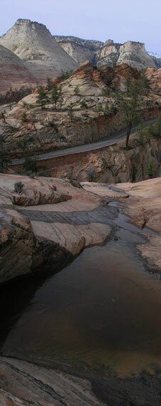
Separation Canyon
Photo Album: Separation Canyon Pictures
Trailhead - From the parks east gate it is 1.4 miles to the pull-out you will want to park at. If you are coming from the south entrance of the park it is 2.5 miles from the east side of the small tunnel. From the parking area located the beaten path leading into the bottom of Clear Creek. The Hike - Once at the bottom of the way head downstream for approximately 400 yards, looking for a beaten path that heads up through the trees. This "trail" will eventually top out on a small ridge to your left. Once atop the ridge, work down into the wash below. The wide open wash is Separation Canyon. Walk Down canyon a short distance to see the twisted falls as they enter Clear Creek below. Heading south and up-canyon there are some nice "desert tanks" initially, but then the wash opens for easy travel as it heads south and upward toward Separation Point. About .75 miles into the hike, the wash splits. By bearing left, the wash becomes a bit congested, yet remains easy travel. Soon a large bowl appears. Turn right up this bowl to gain a ridge on the right. Once on top of the ridge, travel southeast to gain the summit of a small "nipple" known as Separation Point. There are outstanding views to the south and GPS Coordinates WGS84 Datum Parking For Separation Canyon: Scramble out of Clear Creek Separation Peak
Beta: Coordinates and other trail and canyoneering information by Zion Park search and rescue veteran team member Bo Beck and zionnational-park.com author Mary Cisneros.
Suggested Gear: A sturdy pair of shoes are recommend to hike the trails in Zion National Park. Many quality shoes will help grip the rocks and prevent injury.
Zion National Park, UtahHistory of the Thunderbird |
East Zion Lodge Mileage from Stay in the heart of the parks, Mount Carmel Junction, and visit the treasures of the Southwest and Utah. Site Map Zion Hiking |
||||||||||||
|
This is my new favorite quote:
"I don't know who Mary Cisneros is, but I mean zionnational-park.com It's a better site than the NPS's anyway." Written by the authors of the book: Favorite Hikes in and around Zion National Park |
|||||||||||||


 north.
|
Zion History |
|---|
All rights reserved © Copyright Zion National-Park dot com
Do not use text, photos or maps without permission © Zion National-Park dot com
Contact the Author Mary Cisneros with any errors