|
|

|
|||
|
Zion National Park Lodging Park Info Vacation Weather Photos Hike SR-9 Slots Backpack Camping |
||||

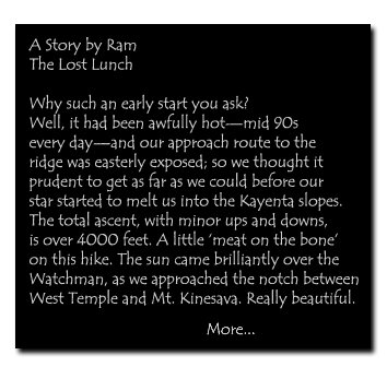
Zion: Mount Kinesava
|
||||||||||||||||||

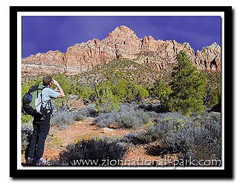
 Mt. Kinesava - This is a strenuous uphill trek, on loose scree and talus. Excellent route finding skills are a must. There is 4th class scrambling along the ramp to the end of the hike. The reward at the top is a spectacular view of Zion, far below and some ancient petroglyphs that are rarely seen by anyone. We assume if you are going to do this difficult of a hike you respect ancient rock are, so we have included directions. Remember the slightest touch can damage the ancient rock art. Treat it with the respect you would a piece of art in a museum. Mount Kinesava's peak is 7276', but this hike does not go that far. From the park boundary head up the ridge. The ridge winds to the south of the large drainage, below on the north. Hike southwest, staying on top of the ridge, headed toward the power line pole. Get on top of the ridge at the power line pole, turn to the (right) northwest, following the ridge toward the juniper table top. It's about a 500' ascent up the ridge.
Directions to Zion National ParkFrom the North: Travel I-15 south, past Beaver. exit on Hwy 20. Follow US-89 to Mount Carmel Junction. Take SR-9 to Zion's east entrance.
|
|
|||
|
|
||||


 Chinle Trailhead - Drive 3.5 miles from Zion's south entrance booth and look for the turn-off on the north side of SR- 9, just past the Springdale Fruit Company. Sadly, there are homes built (Anasazi Plateau Subdivision) on the north hill above the trailhead parking lot but the National Park has secured access to Zion from this trailhead. Turn onto the steep Anasazi Road, drive uphill for a short distance and look for an immediate right hand turn-off. The turn-off to the Chinle Trailhead is unmarked at this point. Park in the large flat, dirt area.
Mt. Kinesava - Walk several hundred yards on the Chinle Trail before leaving the path to bear north-northeasterly, aiming for a long ridge that ascends up and through the Springdale Layer Cliffband. This route is longer and more timely than the route that traditionally has been followed from Serendipity Lane in the Town of Springdale, but avoids the private property of those who have built their homes on the historical trailhead leading to Mt. Kinesava, West Temple and a popular climbing route, Cowboy Ridge.
Rocky Area marked with Cairns - The ridge runs north towards Mt. Kinesava. Loose rocks and dirt make the path to a rocky area above that is marked with cairns. This point is above the first Springdale layer of rock. Continue heading north/northwest, across the flats, through the prickly pear cactus and junipers. You will come to the first drainage. The base of the cliffs are visible to the north.
"Dark Cliff" Landmark - Shoot for the base of the dark cliff that's to the north/northwest. Cross the drainages on the way to the dark cliff, gaining elevation with each one. At the major drainage, head to the south, looking for a shallow spot to cross, getting to the north side of it. There is a ridge on the side of the drainage that makes travel easier. Top out on the second plateau, among the pinion's and junipers. The "dark cliff" landmark becomes evident. Note the blind arch on the lower section.
 Mt. Kinesava Ramp System - Once you have neared the base of the "Brown Cliffs" there will be a drainage between you and the cliff base. Don't enter the drainage, rather, turn southwest and pick your way up the slope to the southwest. This will be a steep slope with a few short cliff bands to negotiate. After about .25 miles you will crest the top of this slope and see a bushy rock ramp leading back to the north/northwest.
Turn around and head back if there is ice or snow on the ramps.
About 100 meters south from the base of the "dark cliff" landmark, head west/southwest (left) up the steep ascent. There is some 4th class scrambling, to the top of the drainage. Stay on the ridge to the south of the drainage (saddle).
Final Ramp to the top of the Saddle - The ramp system that heads back to the north is at the top of the drainage. Take the path to the right, rather than hugging the sheer cliff to the left. This does not look like a ramp, in fact it looks like a scramble of boulders, but its the path to take.Hoodoos on Top - Head due north to the two hoodoos above. Kinesava is the peak back behind and to the left.
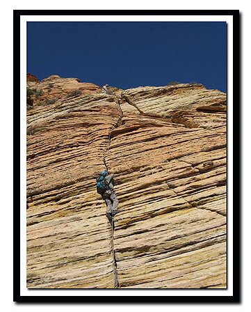
Photo: Bo Beck on Cowboy Ridge.
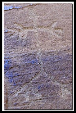
Mt. Kinesava Petroglyphs - Once on top it's a short hike (.3 miles) to the petroglyphs. Once you reach the top of the ramp and arrive at the hoodoos, you will see a faint trail through the thicket of trees. Pop out on the other side of the trees and look for a couple of ponderosa trees to the south, next to a sandstone outcropping. Walk toward the ponderosa's and through the large valley of cacti and low bushes (trees). Take the easiest route to the south/southwest heading for a ramp system and a north facing short cliff band. The petroglyphs are on a large, flat rock face.
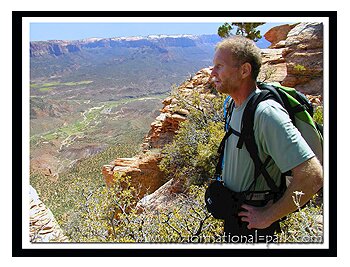
Landmarks - The East Temple towers above the other mountains. To the north (left) is the Twin Brothers, then Mountain of the Sun. The smaller mountain in the forefront is Mt. Spry. On the south or right of the East Temple is Bridge Mountain, Watchman and Johnson Mountain
GPS Coordinates - WGS84 Datum
|
Rocky Area
|
"Dark Cliff" View Point 37°11453N 113°01.501W 5506 feet |
Top of Saddle 37°11687N 113°01.690W |
Hoodoos on Top |
Treat this ancient art as you would that in any indoor museum with care and respect.
Do not touch them in any manner. Do not build a fire near them.
Kinesava Petroglyphs
37°11.777N
113°01.818W
Elevation: 6881 feet
GPS coordinates are only references and may or may not be accurate. Do not rely on GPS coordinates as the sole method of navigation. Always have an accurate, detailed map at hand and have the proper map reading and navigation skills before setting out on any hike. Many of the hikes listed in this guide travel into canyons where a GPS has limited capabilities. Always check your position with a detailed map before dropping into a canyon.
Beta: Coordinates and other trail and canyoneering information by Zion Park search and rescue veteran team member Bo Beck and zionnational-park.com author Mary Cisneros.
To post trip reports, offer corrections, updates, or for more information please visit the Zion National Park Forum
Suggested Gear: A sturdy pair of shoes are recommend to hike the trails in Zion National Park. Many quality shoes will help grip the rocks and prevent injury.
|
|
Zion National Park, Utah
History of the Thunderbird

East Zion Lodge
Vacation House
Group Lodging
East Zion Golf
East Zion RV Park
Vacation Packages
Mileage from
Mt. Carmel Jct.
Zion National Park 12
Bryce Canyon 60
Grand Canyon 85
Cedar Breaks 45
Grand Staircase 9
Dixie Forest 22
Sand Dunes 11
Coyote Butte 57
Red Canyon 47
Tuweep 90
Stay in a hotel the heart of the parks, Mount Carmel Junction, and visit the treasures of the Southwest and Utah.
Site Map
Site Map II
Site Map III
Zion Hiking
Zion Park Hiking
Zion Hiking Advanced
Zion Canyoneering
Kolob Hiking
Greater Zion Area
|
|
"I don't know who Mary Cisneros is, but I mean zionnational-park.com
It's a better site than the NPS's anyway."
Written by the authors of the book: Favorite Hikes in and around Zion National Park
|
Zion History |
|---|
All rights reserved © Copyright Zion National-Park dot com
Do not use text, photos or maps without permission © Zion National-Park dot com
Contact the Author Mary Cisneros with any errors