|
|
 |
|||
|
Zion National Park Lodging Park Info Vacation Weather Photos Hike SR-9 Slots Backpack Camping |
||||

|
|||||||||||||


Directions to Zion National ParkFrom the North: Travel I-15 south, past Beaver. exit on Hwy 20. Follow US-89 to Mount Carmel Junction. Take SR-9 to Zion's east entrance.
|
|
|||
|
|
||||


A high clearance 4WD vehicle is recommended, but even with one the road may be impassible when wet. Make your way to Rockville, which is located on the south side of Zion, just past Springdale, where this route begins. Once in town, turn south on Bridge Road, set your trip-meter and drive south across the old bridge spanning the Virgin River. It's only a short distance before the paved road makes a hard right turn, but to reach your destination go straight on the dirt road rather than turning right. You will climb a steep grade before traversing up to the head of a large bowl. A mile from SR-9 there is a three-way intersection where you need to drive straight instead of turning. Drive past the dwellings on both the right and left as you begin the short, rocky uphill climb to yet another junction. Turn left at the intersection and pass over the wash climbing up the hillside and bearing northeast. At 1.9 miles there is a small pullout on the right and a narrow ATV path doubling back to it. This is where you will leave your vehicle. On the southeast edge of the parking area should be the BLM trailhead sign, however, it is often vandalized and missing, so don't count on it always being there.
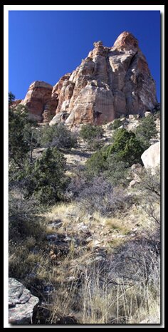
Eagle Crags Trail
The route bears to the southeast for the first half-mile as it slowly traverses and descends into the wash below. Where there is then a gradual ascent, still headed southeast, up the opposite side of the drainage. You begin a gradual climb to the southeast, exposing views of the massive "laccolith" Pine Valley Mountain to the west and the main canyon of Zion to the north. The outcrop of sandstone known as Eagle Crags appears to grow in elevation as each step draws you closer to the base of the towering, magnificent pinnacles.
You will pass through a hikers gate as the trail follows a ridge to the south and a mile farther the path heads in an easterly direction. You will see wonderful views of the Parunuweap basin unfold to the northeast, and a large private reservoir can be seen below to the east in the South Creek drainage. Hiking becomes harder here as elevation increases and you switchback up and toward the eastern tip of the crags.
After some huffing and puffing, you will make it to the top of a ridge and the end of the 2.5 mile route. The views to the south show the slickrock cliffs that rim Lower Mountain. Beyond the ridge, the beaten path becomes faint and difficult to follow. This is where most people will stop and turn around. Past this point is the "Old Cattle Trail" which had been used by cowboys to move cattle to Lower Mountain, Canaan Mountain and the old Sawmill on top. For the backpacker this route is the end of one of the two authors favorite trails, which begins in Hildale, traveling through Water Canyon, up Canaan Mountain and exiting here.
The Eagle Crags themselves are a ridge of the Vermillion Cliffs extending north of Lower Mountain sitting on the plateau of Canaan Mountain. There is ample space and a level area at the end of this trail to settle back for a nice picnic so you can relax and prepare for the downhill hike back to your vehicle. If you are lucky you might even see a climber scaling the sheer stone making their way to the top of the crag along the climbing route known as Mrs. Butterworth.
While resting, see if you can spot the historic Shunesburg settlement in the distance and the slickrock plateau of Canaan Mountain. You will also be able to see various peaks extending to the skyline including: Shunesburg Mountain, Johnson Mountain, De Mille Peak and Zion's Watchman, Mount Kinesava and West Temple.
 Backpacking Option - Past the end of this trail is the "Old Cattle Trail which was once used by cowboys to move cattle to and from Lower Mountain, Canaan Mountain and access the old sawmill on top. For the backpacker this route is the end of the authors favorite trails, which begins in Hildale, Arizona , travels through Water Canyon, up canaan Mountain and exits here.
GPS Coordinates WGS84 Datum
Eagle Crags Trailhead:
37°08.8620N
113°01.866W
Hikers Gate:
37°08.552N
113°01.439W
GPS coordinates are only references and may or may not be accurate. Do not rely on GPS coordinates as the sole method of navigation. Always have an accurate, detailed map at hand and have the proper map reading and navigation skills before setting out on any hike. Many of the hikes listed in this guide travel into canyons where a GPS has limited capabilities. Always check your position with a detailed map before dropping into a canyon.
Beta: Coordinates and other trail and canyoneering information by Zion Park search and rescue veteran team member Bo Beck and zionnational-park.com author Mary Cisneros.
To post trip reports, offer corrections, updates, or for more information please visit the Zion National Park Forum
Suggested Gear: A sturdy pair of shoes are recommend to hike the trails in Zion National Park. Many quality shoes will help grip the rocks and prevent injury.
|
|
Zion National Park, Utah
History of the Thunderbird

East Zion Lodge
Vacation House
Group Lodging
East Zion Golf
East Zion RV Park
Vacation Packages
Mileage from
Mt. Carmel Jct.
Zion National Park 12
Bryce Canyon 60
Grand Canyon 85
Cedar Breaks 45
Grand Staircase 9
Dixie Forest 22
Sand Dunes 11
Coyote Butte 57
Red Canyon 47
Tuweep 90
Stay in a hotel the heart of the parks, Mount Carmel Junction, and visit the treasures of the Southwest and Utah.
Site Map
Site Map II
Site Map III
Zion Hiking
Zion Park Hiking
Zion Hiking Advanced
Zion Canyoneering
Kolob Hiking
Greater Zion Area
"I don't know who Mary Cisneros is, but I mean zionnational-park.com
It's a better site than the NPS's anyway."
Written by the authors of the book: Favorite Hikes in and around Zion National Park
|
Zion History |
|---|
All rights reserved © Copyright Zion National-Park dot com
Do not use text, photos or maps without permission © Zion National-Park dot com
Contact the Author Mary Cisneros with any errors