|
|
 |
|||
|
Zion National Park Lodging Zion Info Vacation Weather Photos Hike Slot Canyons Backpack Camping |
||||

Red ButteRed Butte is the prominent "pyramid" shaped mountain that is visible from the Kolob Road when driving
Photo Album: Red Butte Pictures
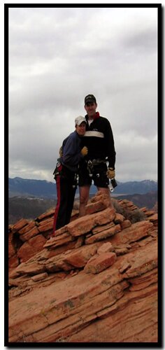
Red Butte - Begin by following the ridge to the west, bypassing the ponderosas. Soon it will be necessary to steer right as the terrain becomes steeper and a cliff band appears in front. The hillside to the right of the cliff is steep but yields with some obvious weaknesses and after .25 miles will top out on a major North - South running ridge and open plateau above. From the plateau it is necessary to travel north to the base of the slickrock mountain. Try to stay near the eastern edge of the ridge as approaching the butte base. Notice some large ponderosas at the base of the slickrock, but be sure not to miss Red Window Arch on a small rock outcropping just before arriving at the base. Now comes the route finding as the mountain has layer after layer of cliff bands. Always look for the most obvious and easiest travel, however keep in mind that there are several spots that require short up climbs. Occasionally the gullies are very steep and don't seem like the right way, but with some exploring decisions will be necessary. The route we followed took us toward the actual peak initially, but as we went higher we found weaknesses that put us toward the eastern side of the mountain. At a very high spot it was necessary to find a ramp that lead into a ramp on the western side of the ridge. Once up the very steep slickrock ramp we were just 100' below the summit and confronted with 5th class climbing. There is a hidden chimney that faces left and seems unsure, but by working onto a ledge and bypassing a loose block we were able to get into the chimney and ascend 50' to a single bolt anchor on top of the pedestal. From the bolt is another ledge and a very short vertical section before becoming a short 20' scramble to the summit. There is a register on top and a rope anchored to a bush for the descent. We rappelled back to the bolt (be careful of the pendulum), and then threw the rope from the bolt off the face rather than try to rappel back down the chimney. A 150' rope is adequate for the 5th class section. GPS Coordinates WGS84 Datum
Route Begins Red Window Arch Summit of Red Butte Beta: Coordinates and other trail and canyoneering information by Zion Park search and rescue veteran team member Bo Beck and zionnational-park.com author Mary Cisneros. To post trip reports, offer corrections, updates, or for more information please visit the Zion National Park Forum
Zion National Park, UtahHistory of the Thunderbird |
East Zion Lodge Mileage from Stay in the heart of the parks, Mount Carmel Junction, and visit the treasures of the Southwest and Utah. Site Map Zion Hiking |
||||||||||||
|
This is my new favorite quote:
"I don't know who Mary Cisneros is, but I mean zionnational-park.com It's a better site than the NPS's anyway." Written by the authors of the book: Favorite Hikes in and around Zion National Park |
|||||||||||||


 Turn off Kolob Road onto Dirt Road
|
Zion History |
|---|
All rights reserved © Copyright Zion National-Park dot com
Do not use text, photos or maps without permission © Zion National-Park dot com
Contact the Author Mary Cisneros with any errors