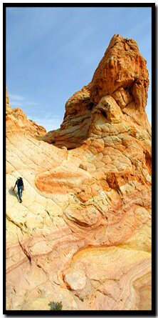
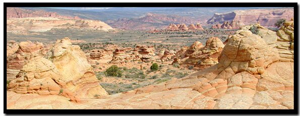
The Coyote Buttes Special Management Area sits between Utah's Grand Staircase-Escalante National Monument and the upper section of the Paria Canyon Wilderness Area - Vermillion Cliffs National Monument. This desolate land contains a disorderly collection of fantastically twisted and striated sandstone. Multitudes of the beehive shaped hills or buttes appear to be enveloped in a sea of colorful petrified waves while other bizarre formations have been contorted into caverns, arches, domes and fragile fins - all slowly crumbling as they continuously succumb to the forces of nature.
At a Glance Photo Album:Paw Hole - Cottonwood Teepees Trail Map:Trail Map South Coyote Buttes Day Hike: Only day hikes are permitted. Overnight camping is not allowed inside the hiking route. Distance: South Coyote Buttes is an exploration around an area rather than a hike leading to a destination, so the mileage will vary depending on how much you want to explore. Average Hiking Time: It will take about 4 hours to see the main area of interest. Difficulty: Moderate. Sun Exposure: There is little to no shade and sand reflects the sun amplifying the effects of heat. Carry plenty of water no matter when you hike, but at least one gallon of water per person in the summer. Trail Usage: Permits: Contact Kanab Field office Kanab BLM: 318 N 100 E 435.644.4600 Paria BLM: Located 4 miles east of the Wire Pass turn-off. Trail Conditions: A 4WD is required to get to the South Coyote Buttes trailheads. Be aware that even with a 4WD the main road, due to the clay content, is impassable and dangerously slippery if wet. Trailhead: Lone Tree Reservoir off House Rock Road. Trailend: Same as trailhead. Best Season: This is a nice hike in the spring, fall and winter because the direct sun makes it too hot in the summer but quite comfortable during the other seasons of the year. Snow on the rock adds interest for many photographers. South Coyote Buttes Elevation: 5789 feet
Top of Cottonwood Teepees Elevation: 5933 feet Paw HoleStarting Elevation: 5950 feet Paw Hole Highest Elevation: 6350 feet Off the Beaten Path: Yes. Restrooms: There is a vault toilet at the Wire Pass Trailhead and another at the Stateline Campground.
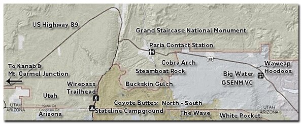
House Rock Road - From Kanab, drive 40 miles east on US-89. Turn right onto House Rock Road, a dirt road, located between mile markers 25 and 26, just before a guardrail and a sweeping left hand curve in the road. Set your odometer and drive for 17 miles. You will travel past the Wire Pass parking lot at 8.3 miles, and then the Utah - Arizona state line, which is also the border of the Grand Staircase-Escalante National Monument in Utah and the Vermillion Cliffs National Monument in Arizona. When you near 17 miles look for an unmarked turn-off on the left side of the road. If you get to the Honeymoon Trail sign, which is 18 miles from US-89, you have gone too far.
There are no established trails in this area, so please be careful where you walk and do not climb or scramble on rocks in South Coyote Buttes that might result in breaking thefragile mounds and fins.
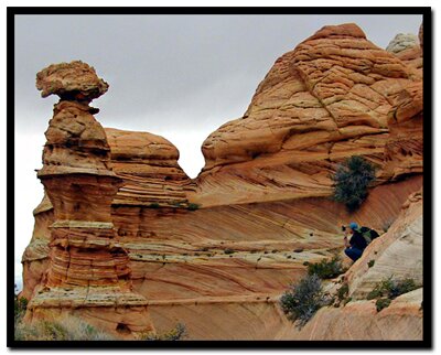
Paw Hole Trailhead - The first landmark, Lone Tree Reservoir, is just past the turn-off. Even though the name implies that you will find a water supply, you will probably only see a single juniper tree sitting in a dry hole. Continue past it where shortly, you should see a welcome sign for the Vermillion Cliffs National Monument, then farther down the road there is a sign for Coyote Buttes. The road is lined with junipers, sagebrush and purple, red, orange and white wildflowers. Parking for the Paw Hole Trailhead is 2.5 miles from the turn-off.Paw Hole - From the parking area, look for the small, but interesting arch at the top of the first hoodoo. The climb to it is a fourth class scramble and not recommended due to the fragile rock. The southeast side of the trailhead offers some nice formations as well and toward the northeast there is a beautiful sandstone bowl at the end of the dunes. From the parking area head north-northeast, going though the fence, heading for the buttes. There are no established trails, instead this route is more of an exploration around the rocks. Hike around the bowl and along the sand toward the hoodoos to the northeast. Once you turn west, and top out on the ridge, House Rock Road appears to the west and a variety of oddly shaped, upright rock structures become visible. Below and on the western slope the sandstone gets really interesting. If you take the route on the western edge of the butte there is some fourth class climbing at the bottom of the cliff. Locate the angular shaped grotto. Inside you will find fragile fins and soft sand, then take some time to explore the area around it before hiking back to the parking area.
Cottonwood Teepee - Set your odometer again and head east. It is 3.25 miles to Windmill Junction at Poverty Flat then another 2.5 miles to the Cottonwood Teepee parking area. Turn north, or left, just prior to the windmill and other dilapidated structures. Travel north through the gate into the South Coyote Buttes Special Permit Area. Leave any gates as you found them. Soon the road becomes impassible. Both north and west from the parking area are large hoodoos called the Cottonwood Teepees. Park and hike over the desert sand to the foremost rock formations on the left or west side of the road. Once on top, Cottonwood Spring can be seen in the wash to the north and below the formations. Tee-pees can be viewed both to the north and south of the slickrock plateau. Fragile windswept layers of tangerine swirls prevail here like an elegant layered dessert. The vivid display of colors is courtesy of generous mineral deposits. Rounded domes and flat-capped stone fill the desert oasis and fossilized dunes of sand show off a wonder of weird patterns.
GPS Coordinates WGS84 Datum
Turn-off Highway 89
onto House Rock Road
37°07.567N
111°58.612W
Parking lot at Wire Pass (North Coyote Buttes/ Buckskin Gulch)
37°01.171N
112°01.483W
Turn off of House Rock Road
to Lone Tree Reservoir
36°54.872N
112°03.096W
Paw Hole Parking
and Trailhead
36°55.447N
112°01.038W
Turn north from Poverty Flat road to South Coyote Buttes and Cottonwood Spring and Cove
36°55.631N
111°58.183W
Parking for South Coyote Buttes Formations and Queen
36°57.611N
111°58.706W
Cottonwood Spring Formations
36°57.901N
111°59.481W
The Queen
36°57.599N
111°58.545W
GPS coordinates are only references and may or may not be accurate. - Do not rely on GPS coordinates as the sole method of navigation. Always have an accurate, detailed map at hand and have the proper map reading and navigation skills before setting out on any hike. Many of the hikes listed in this guide travel into canyons where a GPS has limited capabilities. Always check your position with a detailed map before dropping into a canyon.
Beta: Coordinates and other trail and canyoneering information by Zion Park search and rescue veteran team member Bo Beck and zionnational-park.com author, Mary Cisneros.
Suggested Gear: Rope, webbing, harness and rappelling device. A sturdy pair of shoes are recommend for canyoneering in Zion . Quality shoes will help grip the rocks and prevent injury. Experienced Zion hikers and canyoneers like the Sportiva Exum Ridge. This shoe is great for hiking, bouldering and canyoneering.
The Queen - Head back to where you parked and continue east to where there is another cluster of hoodoos. Look for a rounded, towering formation. This rock has been dubbed, unofficially, as the Queen, signifying its similarity to a chess piece. It is the main show in the sandstone formations to the right of the road.
Paria Canyon Directions
From Mount Carmel Junction, drive 17 miles to Kanab. Leave Kanab, drive 40 miles east on US Highway 89. The turn-off is located on the south (right side coming from Kanab) side of the road. Its between mile markers 25 and 26, at a curve in the road, at the end of a guard rail. Turn at the unmarked dirt road. This is House Rock Road. Follow the road to your preferred trailhead. Directions to the Wave
South Coyote Buttes
Lodging and services are available on the gorgeous east side of Zion National Park, where guests are close to Zion National Park (12 miles), Bryce Canyon National Park (60 miles), Cedar Breaks National Monument (45 miles), Coral Pink Sand Dunes (12 miles), and the North Rim of the Grand Canyon (85 miles). It's where city traffic is absent and the skies are bright and clean.
Stateline Campground - between Arizona and Utah
It's 10-miles to the Stateline Campground from US Highway 89. There are only 4 spots, so if you want to camp get a spot early. It's first come first use. Two of the camp sights are in Utah and two are in Arizona. There is no water, but there are vault toilets.
Coyote Buttes Special Permit Offices Arizona Strip Field Office: 345 East Riverside Drive St. George, Utah 84790 435.688.3200 Kanab Office: 318 N 100 E Kanab, Utah 84741 435.644.4600. Paria Contact Station: Located south of US Highway 89 between mile post 21 and 22,
between Kanab and Page, Arizona.
Paria Canyon Wilderness contains Coyote Buttes Special Management Area which was made popular by the Wave. The sandstone buttes sit at the bottom of Utah's Grand Staircase-Escalante National Monument and the upper section of Arizona's Paria Canyon Wilderness.
Mileage from
Mt. Carmel Jct.
Zion National Park 12
Bryce Canyon 60
Grand Canyon 85
Cedar Breaks 45
Grand Staircase 9
Dixie Forest 22
Sand Dunes 11
Coyote Butte 57
Red Canyon 47
Tuweep 90
Stay in the heart of the parks, Mount Carmel Junction, and visit the treasures of the Southwest and Utah.
This is my new favorite quote:
"I don't know who Mary Cisneros is, but I mean zionnational-park.com
It's a better site than the NPS's anyway."
Written by the authors of the book: Favorite Hikes in and around Zion National Park


 Trailhead: Lone Tree Reservoir off House Rock Road.
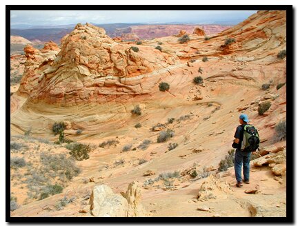 Paw Hole Trailhead - The first landmark, Lone Tree Reservoir, is just past the turn-off. Even though the name implies that you will find a water supply, you will probably only see a single juniper tree sitting in a dry hole. Continue past it where shortly, you should see a welcome sign for the Vermillion Cliffs National Monument, then farther down the road there is a sign for Coyote Buttes. The road is lined with junipers, sagebrush and purple, red, orange and white wildflowers. Parking for the Paw Hole Trailhead is 2.5 miles from the turn-off.Paw Hole - From the parking area, look for the small, but interesting arch at the top of the first hoodoo. The climb to it is a fourth class scramble and not recommended due to the fragile rock. The southeast side of the trailhead offers some nice formations as well and toward the northeast there is a beautiful sandstone bowl at the end of the dunes. From the parking area head north-northeast, going though the fence, heading for the buttes. There are no established trails, instead this route is more of an exploration around the rocks. Hike around the bowl and along the sand toward the hoodoos to the northeast. Once you turn west, and top out on the ridge, House Rock Road appears to the west and a variety of oddly shaped, upright rock structures become visible. Below and on the western slope the sandstone gets really interesting. If you take the route on the western edge of the butte there is some fourth class climbing at the bottom of the cliff. Locate the angular shaped grotto. Inside you will find fragile fins and soft sand, then take some time to explore the area around it before hiking back to the parking area.
 Turn north from Poverty Flat road to South Coyote Buttes and Cottonwood Spring and Cove