Wahweap Hoodoos:
Grand Staircase-Escalante
National Monument
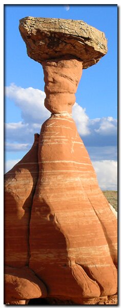
Photographs of white stone described as goblins, ghosts, toadstools and other oddities herald the unique geology of the sun scorched lands of the Southwest. Groves of capped white columns are located near Big Water at the edge of the Grand Staircase-Escalante National Monument. The cap of the hoodoo is Dakota Sandstone which was a beach of an incoming seaway. It is 100 million years old, and the post of the hoodoos is Entrada Sandstone that is 160 million years old. There should be a layer of Morrison Sandstone but for some reason it wasn't laid down and isn't present. This is why there is such a large gap in the age of the cap and post . Near the Wahweap Hoodoos you can take a short walk to the darker side where brown "toadstools" make an appearance just off the highway at the Rimrocks.
Entrance Fees: There are no fees to enter the Grand Staircase Escalante National Monument from the Cottonwood Road or to hike the trail on this page.
Photo Album:Wahweap Hoodoo photos Map:Wahweap Hoodoo Trail Map Day hike: yes Trail distance: 9.2 miles/14.81km round trip Average Hiking Time: 5 hours Trail Usage: Low Difficulty: This hike is through a wash that can be very slippery if wet. When it's dry and hot there is little reprieve from the sun. Trail conditions: Easy wash hiking. Full sun and hot in the summer. Trailhead: Wahweap Creek just outside of Big Water, Utah Trailend: Same as trailhead Best Season: Spring or Fall. This trail is in full sun and it is often too hot in the summer to hike. Trail access: Year-round Off the beaten path: Yes Hazards: Flash flood danger and slippery clay Elevation Gain: 229' Starting Elevation: 4042' Highest Elevation: 4271' at the peak. Water availability: Intermittent water in the washes. Might be dry in the summer.
Wahweap Hoodoos Trailhead - From Kanab, drive east on Highway 89 toward Lake Powell for approximately 55 miles, until reaching the small town of Big Water, Utah. At Big Water, turn left on the Ethan Allen Road, which is between mile markers 6 and 7, directly across the highway from the Big Water Grand Staircase-Escalante Visitor Center. Follow Ethan Allen past several streets to a "T" in the road. Turn left at the "T" and bypass the old softball field on the left side of the now gravel road. Follow this wide, graded road past two fish hatcheries. Continue north past a corral which is located 3 miles from Highway 89. If driving a 2WD, park on the right side of the road just before crossing the creek and then begin the hike up Wahweap Creek. High clearance 4WD vehicles can continue past the corral, crossing Wahweap Creek, and then continue for .3 miles. The trail begins in Wahweap Creek just below the 4WD parking area.
Wahweap Creek - Start at the confluence of Coyote Creek, Nipple Creek and Wahweap Creek. The trip through Wahweap Wash is a leisurely hike that is easily navigated. Be aware that if the clay at the edge of the creek is wet it can be extremely slippery. Hike north up Wahweap Wash. Avoid damaging the environment by staying in the watercourse whenever possible. At approximately a half-mile, a dilapidated "hanging fence" is suspended over the creek bed. Continue past the fence hiking in the wide open wash of Wahweap Creek. Spectacular views of the gentle sloping fields of "pocketed" white Entrada Sandstone are seen to the north. Farther up the wash, sandstone formations appear taller and are vertical in nature. Continue north, heading for the large "red buttress" on the eastern side of the creek. At the 2 mile mark, stop and hike toward the obvious white hoodoos located on the west (left) side of the wash. Continue toward the first teasers of brown capped, tall white hoodoos. At 2.3 miles, you should be up against the white, slick rock band on the western side of the wash. At 3 miles, more delicate white hoodoos become apparent. At 3.6 miles, hikers will reach the first white towering hoodoo landmark.
Second Cove of White Hoodoos "Hoodoo Central" - To get to the next cove of hoodoos at 4 miles, stay close to the edge of the white rock and avoid as much of the dense tamarisk as possible. This path winds around into a deep grotto with more hoodoos. There is a beaten path close to the white columns, but staying at a distance is beneficial to the fragile rock and will not damage the surrounding cryptobiotic soil. The spectacular white hoodoos are formed by erosion of soft Entrada Sandstone and are easily damaged. Respect them by taking pictures from a distance and do not try to climb on or around them.
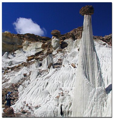
Third Cove of White Hoodoos"Towers of Silence" - The "famous photographed white hoodoo" is found at the 4.3 mile mark. Upon arrival at this allotment of unusual rock, one would almost sense that the formations have lives of their own, as they seem to be sprouting from the earth. The soft sandstone spires set the imagination free. This is the end of the alcoves. Relax in the shade, have a lunch and prepare for the picturesque hike back down Wahweap Wash to exit.
Rimrock Hoodoos - If time and energy permit, after hiking to the Wahweap Hoodoos, the short side trip to the Rimrocks will top off the day of hoodoo viewing. This wonderful and easily accessed cove contains darker versions as well as magnificent pearly white columns. Nature's handiwork is mingled with whimsical peculiarities and nonsense in this arid land of sand and stone. From Big Water, drive 12 miles west on Highway 89. Look for a small parking area and trailhead kiosk on the right side (north) of the road. There will be a register box and a hiker's gate to pass through.
After following the trail north for approximately .6 miles, weaving alongside the wash and then dropping into the watercourse, hoodoos will become visible ahead. Notice the white rock formations to the right and red rock formations to the left. Both directions lead to the unique hoodoos known as the Rimrocks. The "Toadstool Hoodoo" can be found by walking up the left hand wash at the intersection of the two washes. The trails branch either left to the red rock hoodoos or by taking the right hand wash, the hoodoos are formed in the white rock.
GPS Coordinates Data: WGS84 - GPS coordinates are only references and may or may not be accurate. Do not rely on GPS coordinates as the sole method of navigation. Always have an accurate, detailed map at hand and have the proper map reading and navigation skills before setting out on any hike. Many of the hikes listed in this guide travel into canyons where a GPS has limited capabilities. Always check your position with a detailed map before dropping into a canyon.
Trailhead-Non-4WD parking
37°06.367 N
111°41.206 W
Trailhead-4WD parking
37 06.769 N
111 41.309 W
Hoodoo Central - 4 miles
37°09.652N
111°42.740W
Towers of Silence
4.3 miles
37°09.749N
111°42.708W
Rimrock Hoodoos
12 miles west of Big Water, just
.75 miles north of Highway 89.
37°06.504 N
111°52.264 W
Rimrock Hoodoos - If time and energy permit, after hiking to the Wahweap Hoodoos, the short side trip to the Rimrocks will top off the day of hoodoo viewing. This wonderful and easily accessed cove contains darker versions as well as magnificent pearly white columns. Nature's handiwork is mingled with whimsical peculiarities and nonsense in this arid land of sand and stone. From Big Water, drive 12 miles west on Highway 89. Look for a small parking area and trailhead kiosk on the right side (north) of the road. There will be a register box and a hiker's gate to pass through.
After following the trail north for approximately .6 miles, weaving alongside the wash and then dropping into the watercourse, hoodoos will become visible ahead. Notice the white rock formations to the right and red rock formations to the left.
Both directions lead to the unique hoodoos known as the Rimrocks. The "Toadstool Hoodoo" can be found by walking up the left hand wash at the intersection of the two washes. The trails branch either left to the red rock hoodoos or by taking the right hand wash, the hoodoos are formed in the white rock.
Directions: East Zion to the
Grand Staircase-Escalante National Monument
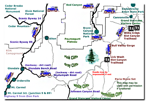
From Salt Lake City, travel south on I15 to U-20. Exit on U-20. Turn south on U-89 and follow U-89 to Glendale.
From Las Vegas: Travel I15 to exit 16. Follow U-9 to the south entrance of Zion and through to the east entrance. Take U-9 for 12 miles to Mt. Carmel Jct, where U-89 and U-9 meet. Drive north on U-89 to Glendale. From Glendale, turn right on 300 N. (Bench Road) Follow the graded dirt road, Skutumpah, into the Grand Staircase. Remember the Grand Staircase is a wild and remote place. The dirt roads may be impassible when wet and there is usually no water, services or cell phone access. Skutumpah is a backway and should only be traveled in dry conditions. Call for road and weather information before travel: 435.644.4680
A single Rimrock Hoodoo
Lodging and services are available on the gorgeous east side of Zion National Park, where guests are close to Zion National Park (12 miles), Bryce Canyon National Park (60 miles), Cedar Breaks National Monument (45 miles), Coral Pink Sand Dunes (12 miles), and the North Rim of the Grand Canyon (85 miles). It's where city traffic is absent and the skies are bright and clean.
Grand Staircase-Escalante Roads - Pristine and remote describes the roadways within the Grand Staircase Escalante National Monument. Highway 89 defines the southern border and Highway 12 accesses the northern side. In addition to Highways 12 and 89, there are 959 miles of open road in the Grand Staircase. Glendale, Utah, located on Highway 89, northeast of Zion National Park, connects the east side of Zion to Bryce Canyon via the Glendale Bench Road and the scenic backway, Skutumpah Road. To the north, Highway 12 connects Tropic and Boulder, Utah. At the southern end of the monument, roads connect Kanab, Utah and Page, Arizona. The most popular roads in the Grand Staircase are probably Skutumpah Road accessed either by the Glendale Bench Road, near the east entrance to Zion, or the Johnson Canyon Road near Kanab, both leading to Kodachrome Basin near Bryce Canyon. All interior roads except for portions of the Burr Trail and Johnson Canyon Road are unpaved and may be impassible if wet.
Beta: Coordinates and other trail and canyoneering information by Zion Park search and rescue veteran team member Bo Beck and zionnational-park.com author Mary Cisneros.
To post trip reports, offer corrections, updates, or for more information please visit the Zion National Park Forum
Suggested Gear: A sturdy pair of shoes are recommend to hike the trails in Zion National Park. Many quality shoes will help grip the rocks and prevent injury.
Mileage from
Mt. Carmel Jct.
Zion National Park 12
Bryce Canyon 60
Grand Canyon 85
Cedar Breaks 45
Grand Staircase 9
Dixie Forest 22
Sand Dunes 11
Coyote Butte 57
Red Canyon 47
Tuweep 90
Stay in the heart of the parks, Mount Carmel Junction, and visit the treasures of the Southwest and Utah.
This is my new favorite quote:
"I don't know who Mary Cisneros is, but I mean zionnational-park.com
It's a better site than the NPS's anyway."
Written by the authors of the book: Favorite Hikes in and around Zion National Park


 Wahweap Hoodoos:
 Towers of Silence
 Rimrock Hoodoos - If time and energy permit, after hiking to the Wahweap Hoodoos, the short side trip to the Rimrocks will top off the day of hoodoo viewing. This wonderful and easily accessed cove contains darker versions as well as magnificent pearly white columns. Nature's handiwork is mingled with whimsical peculiarities and nonsense in this arid land of sand and stone. From Big Water, drive 12 miles west on Highway 89. Look for a small parking area and trailhead kiosk on the right side (north) of the road. There will be a register box and a hiker's gate to pass through.