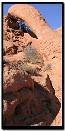
Stunning Cobra Arch is nestled in a quiet corner of the Paria Canyon Wilderness, just north of one of the premiere slot canyons in the Southwest - Buckskin Gulch. The uniquely shaped structure rises up 30' from the ground and spans 35'. Its namesake is unmistakable, from the hood at the crest of the rock formation to the serpent-like arranged striations down the length of the arch. Enroute to the destination, the path passes a marvelous display of crossbedded sandstone as well as a smattering of precariously stacked rocks. From the arch, the views to the south, east and west encompass the splendor of the Paria Canyon-Vermillion Cliffs Wilderness including North and South Coyote Buttes special permit areas, Steamboat Rock and White Pocket.
Cobra Arch at a Glance Photo Album:Cobra Arch Photos Topo Map:Cobra Arch Map Day Hike: Yes Distance: Distance from Trailhead to Arch using Rim Trail: 3.35 Miles (Optional Cross Country Route Below "The Dive", 2.5 Miles) Average Hiking Time: 5 hours. Equipment: Wear sticky rubber hiking shoes and take 3 quarts of water per person, sun protective clothing, map, compass, energy food and emergency gear. . Difficulty: Moderately strenuous. Permits: Not required. Trailhead: A dirt road located 8 miles south of Highway 89 between Page, AZ and Kanab, UT. Trailend: Same as trailhead. Trail Access: Year-round but if the road is wet or there is melting snow it could be impassable. A 4WD is suggested, but a high clearance vehicle is required. Off the Beaten Path: Yes Best Season: It's best to hike this route in the winter or early spring when it's not as hot, but this is a year-round trail as long as the road is drivable. When its hot out, hike early in the morning. Total Descent/Ascent: 350'
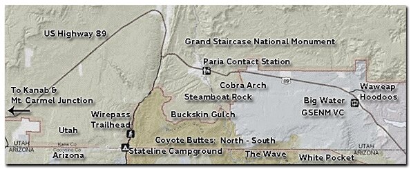
Trailhead - Travel east on Highway 89 from Kanab toward Page. The road dips south just before the Cockscomb formation and then sweeps east at the turn-off for House Rock Valley Road. Set your odometer at this point and continue east on Highway 89 for 4.3 miles. Where just prior to crossing the Paria River you will see the Outpost Restaurant on the right side of the highway. Turn onto the dirt road and reset your trip meter. This road climbs a "spine" that could be hazardous in wet conditions due to the clay surface and long drop offs. The road is not marked at first, but soon you will see signs. Stay on Kane County Road 6020 (BLM Road 750) which is the more heavily traveled dirt road you began on. There are many intersections, but ignore them. The main road runs up Long Canyon, to the southeast for a couple of miles and then breaks out of Long Canyon and climbs just south of it. This road climbs another "spine" in the middle of the canyon, again with long drop offs on either side. Soon the road tops out on a plateau and arrives at a fork 4.2 miles from Highway 89. Stay left, keeping on the main road, doing the same with the next which is bypassed at 4.4 miles and enters from the right. A third fork is at 4.6 miles and once again continue left on the main road. At 5.1 miles two roads appear, one to the right and one to the left, but continue straight. The path becomes sandy with small ups and downs. It passes one deep wash at 6.4 miles that may require a 4WD to navigate it. At 7.8 miles the road passes a barbed wire fence and just past this is a large juniper tree and a pull-out where you will see a register box.
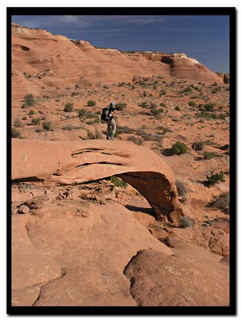
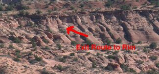
Once below the cliffband, travel south, staying close to the now elevating sandstone walls on hikers left. Interesting balanced rock structures are passed, several washes are crossed, and after one-mile it will be necessary to ascend a tall sand dune. At the top of the dune is a level plateau and a 150' high sandstone mountain. Walk around the mountain and begin travel southeasterly across the plateau until it descends to a group of small dome shaped sandstone mounds. This diverse area of sunbathed, misshapen sandstone is highly photogenic. Cobra Arch is on the backside of this group of mounds. The arch is spectacular and the surrounding area offers shaded areas for lunch and a break before the hike back.
GPS Coordinates WGS84 Datum
Cobra Arch Trailhead
37°02.663 N
111 55.222 W
Scramble Down from Rim
37°01.916 N
111 53.745 W
Arch
37°01.233 N
111°53.754 W
GPS coordinates are only references and may or may not be accurate. Do not rely on GPS coordinates as the sole method of navigation. Always have an accurate, detailed map at hand and have the proper map reading and navigation skills before setting out on any hike. Many of the hikes listed in this guide travel into canyons where a GPS has limited capabilities. Always check your position with a detailed map before dropping into a canyon.
Paria Canyon Directions
From Mount Carmel Junction, drive 17 miles to Kanab. Leave Kanab, drive 40 miles east on US Highway 89. The turn-off is located on the south (right side coming from Kanab) side of the road. Its between mile markers 25 and 26, at a curve in the road, at the end of a guard rail. Turn at the unmarked dirt road. This is House Rock Road. Follow the road to your preferred trailhead. Directions to the Wave
Cobra Arch in Paria Canyon
Lodging and services are available on the gorgeous east side of Zion National Park, where guests are close to Zion National Park (12 miles), Bryce Canyon National Park (60 miles), Cedar Breaks National Monument (45 miles), Coral Pink Sand Dunes (12 miles), and the North Rim of the Grand Canyon (85 miles). It's where city traffic is absent and the skies are bright and clean.
Stateline Campground - between Arizona and Utah
It's 10-miles to the Stateline Campground from US Highway 89. There are only 4 spots, so if you want to camp get a spot early. It's first come first use. Two of the camp sights are in Utah and two are in Arizona. There is no water, but there are vault toilets.
Coyote Buttes Special Permit Offices Arizona Strip Field Office: 345 East Riverside Drive St. George, Utah 84790 435.688.3200 Kanab Office: 318 N 100 E Kanab, Utah 84741 435.644.4600. Paria Contact Station: Located south of US Highway 89 between mile post 21 and 22,
between Kanab and Page, Arizona.
Paria Canyon Wilderness contains Coyote Buttes Special Management Area which was made popular by the Wave. The sandstone buttes sit at the bottom of Utah's Grand Staircase-Escalante National Monument and the upper section of Arizona's Paria Canyon Wilderness.
Mileage from
Mt. Carmel Jct.
Zion National Park 12
Bryce Canyon 60
Grand Canyon 85
Cedar Breaks 45
Grand Staircase 9
Dixie Forest 22
Sand Dunes 11
Coyote Butte 57
Red Canyon 47
Tuweep 90
Stay in the heart of the parks, Mount Carmel Junction, and visit the treasures of the Southwest and Utah.
This is my new favorite quote:
"I don't know who Mary Cisneros is, but I mean zionnational-park.com
It's a better site than the NPS's anyway."
Written by the authors of the book: Favorite Hikes in and around Zion National Park


 Once below the cliffband, travel south, staying close to the now elevating sandstone walls on hikers left. Interesting balanced rock structures are passed, several washes are crossed, and after one-mile it will be necessary to ascend a tall sand dune. At the top of the dune is a level plateau and a 150' high sandstone mountain. Walk around the mountain and begin travel southeasterly across the plateau until it descends to a group of small dome shaped sandstone mounds. This diverse area of sunbathed, misshapen sandstone is highly photogenic. Cobra Arch is on the backside of this group of mounds. The arch is spectacular and the surrounding area offers shaded areas for lunch and a break before the hike back.
 GPS Coordinates WGS84 Datum