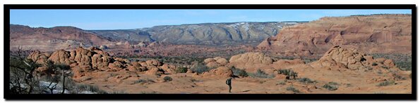
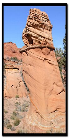
border

Paria Canyon: Steamboat Rock

Sometimes thought of as a taboo area because of the proximity to North and South Coyote Buttes Special Permit Areas, the region east of these pristine zones is accessible without need of special permits. Nonetheless, because of unrestricted access, these areas need to be respected as if they are being monitored and preserved in the same way. Steamboat Rock is another of the special gems that dot this amazing region.

Steamboat Rock - Paria Canyon

There are several ways to access Steamboat Rock; one of these accesses is from the south as if entering South Coyote Buttes Cottonwood Teepees. Steamboat Rock lies in Utah and the easiest access is made from Arizona through deep and sandy roads in the Vermillion Cliffs National Monument. The drive will end just a short distance south of Steamboat Rock, leaving an easy .75 mile hike, on mostly level terrain, to arrive at the southern base of Steamboat. It is a 3.5 mile hike to circumnavigate the entire butte. The southwestern end of Steamboat Rock is mostly weathered sandstone domes of low elevation with several interesting formations. Walking along the northwestern flank crosses several washes with Buckskin Gulch winding its way through the desert just below. Once at the northeastern tip, views of the Paria Plateau unfold in the east. In the distance, to the south, White Pocket is clearly visible. Walking back along the southeast base of Steamboat Rock, small coves of fragile fins and crossbedded formations lead to some fine hoodoos. By keeping a keen eye, one will also see a small window in the rock high up before arriving once again near the southwestern end.

Steamboat Rock at a Glance
Photo Album:
Steamboat Rock Photos
Topo Map:
Steamboat Rock Map
Day Hike:
Yes
Distance: 5.2 miles round-trip.
Average Hiking Time: 4 hours.
Equipment: Sticky Rubber Hiking Shoes, 3 quarts of water per person, sun protective clothing, Map and compass (GPS optional).
Difficulty:
Moderate.
Permits: Not required.
Trailhead: Off Highway 89 Between Page, Az. And Kanab, Ut. South Coyote Buttes Area, Vermillion Cliffs National Monument, Paria Plateau
Trailend: Same as trailhead.
Trail Access: Year-round but if the road is wet or there is melting snow it could be impassable. A 4WD is required.
Off the Beaten Path: Yes
Best Season: This is year-round as long as the road is drivable. Summer months could be dangerously hot.
Elevation: + 300' - 300'

Directions to Steamboat Rock - From Kanab, drive 40 miles east on Highway 89. The turn onto House Rock Valley Road is located on the south side of the road (right side driving from Kanab). It is located between mile markers 25 and 26, before a sweeping left hand curve in the road, prior to a guard rail protecting the curve. Slow down and turn right just before the guard rail. This north-south running road is House Rock Valley Road. The road soon becomes dirt and may be impassible if wet. Continue past the Wire Pass Trailhead (8.5 miles from Highway 89) to the Utah - Arizona state line (10 miles from Highway 89). This is the border of the Grand Staircase-Escalante National Monument in Utah and the Vermillion Cliffs National Monument in Arizona. Keep driving south for another 6.5 miles past the Stateline Campground and look for the dirt road that turns left and to Lone Tree Reservoir. Turn left at Lone Tree Reservoir and follow the main, sandy 4WD road to the east for 2.4 miles to the Paw Hole Trailhead. Beyond Paw Hole the road becomes even deeper sand and may require tire deflation to prevent becoming stuck. There will be a gate at .7 mile, and a second gate at .9 mile after passing Paw Hole. Close the gates after passing through them.

Map Bryce Canyon National Park Coral Pink Sand Dunes Map Grand Staircase-Escalante Map Bryce Canyon National Park Grand Canyon National Park, Arizona - North Rim Map Red Canyon, Dixie National Forest, Utah Lodging: Zion National Park Zion National Park Cedar Breks National Monument, Utah Dixie National Forest: Cedar Mountain Zion National Park Map Coral Pink Sand Dunes Map Zion National Park Lodging Cedar Breaks and Dixie National Forest Map Bryce Canyon and Red Canyon Map Grand Staircase-Escalante Map Zion National Park Map Coral Pink Sand Dunes Map Zion National Park Lodging Cedar Breaks and Dixie National Forest Map Grand Staircase-Escalante Map Bryce Canyon National Park Zion National Park Map Coral Pink Sand Dunes Map Zion National Park Lodging Cedar Breaks and Dixie National Forest Map Bryce Canyon and Red Canyon Map Grand Staircase-Escalante Map Zion National Park Map Coral Pink Sand Dunes Map Zion National Park Lodging Cedar Breaks and Dixie National Forest Map Grand Staircase-Escalante Map Bryce Canyon National Park Zion National Park Map Coral Pink Sand Dunes Map Zion National Park Lodging Cedar Breaks and Dixie National Forest Map Bryce Canyon and Red Canyon Map Grand Staircase-Escalante Map Zion National Park Map Coral Pink Sand Dunes Map Zion National Park Lodging Cedar Breaks and Dixie National Forest Map Grand Staircase-Escalante Map Bryce Canyon National Park Zion National Park Map Coral Pink Sand Dunes Map Zion National Park Lodging Cedar Breaks and Dixie National Forest Map Bryce Canyon and Red Canyon Map Grand Staircase-Escalante Map Zion National Park Map Coral Pink Sand Dunes Map Zion National Park Lodging Cedar Breaks and Dixie National Forest Map Grand Staircase-Escalante Map Bryce Canyon National Park Zion National Park Map Coral Pink Sand Dunes Map Zion National Park Lodging Cedar Breaks and Dixie National Forest Map Bryce Canyon and Red Canyon Map Grand Staircase-Escalante Map Zion National Park Map Coral Pink Sand Dunes Map Zion National Park Lodging Cedar Breaks and Dixie National Forest Map Bryce Canyon and Red Canyon Map Grand Staircase-Escalante Map Zion National Park Map Coral Pink Sand Dunes Map Zion National Park Lodging Cedar Breaks and Dixie National Forest Map Grand Staircase-Escalante Map Bryce Canyon National Park Zion National Park Map Coral Pink Sand Dunes Map Zion National Park Lodging Cedar Breaks and Dixie National Forest Map Bryce Canyon and Red Canyon Map Grand Staircase-Escalante Map Zion National Park Map Coral Pink Sand Dunes Map Zion National Park Lodging Cedar Breaks and Dixie National Forest Map Grand Staircase-Escalante Map Bryce Canyon National Park Zion National Park Map Coral Pink Sand Dunes Map Zion National Park Lodging Cedar Breaks and Dixie National Forest Map Bryce Canyon and Red Canyon Map Grand Staircase-Escalante Map Zion National Park Map Coral Pink Sand Dunes Map Zion National Park Lodging Cedar Breaks and Dixie National Forest Map Bryce Canyon and Red Canyon Map Grand Staircase-Escalante Map Zion National Park Map Coral Pink Sand Dunes Map Zion National Park Lodging Cedar Breaks and Dixie National Forest Map Bryce Canyon and Red Canyon Map Grand Staircase-Escalante Map Book: Paria Canyon, Coyote Buttes, Zion and moreAt 2 miles past the second gate and just before arriving at the windmill at Poverty Ranch (the windmill will be in view several hundred yards before actually arriving ) there will be a road on the left. This is the road to Cottonwood Teepees, Cove and Spring in the South Coyote Buttes Special Permit area. Reset the trip meter here. It will be necessary to turn left (north) on this road and follow the main road, ignoring side roads, for 1.5 miles. At 1.5 miles from the intersection near the windmill the road comes to a fence, gate and sign depicting the South Coyote Buttes Special Permit Area. The sign states that a permit is required to enter, however according to the BLM office, it is alright to pass through the gate to access the road immediately on the right after entering without a permit. Turn right on this seldom used road and travel northeast. The road is not used very much and is even deeper sand than the road that was previously traveled. At this point tire deflation may become necessary. Follow this road for the next few miles. On the way remnants of ranching (water tanks and water lines) are passed and driven over. After passing a second water tank at 4.8 miles, on the left, Steamboat Rock is apparent. At 5.2 miles stop and park. The hike begins.

There is no formal trail established, but it will soon be evident that wandering and exploring is the main fare. There is much to see, but be sure to walk lightly and avoid the fragile rock fins so that others may enjoy natures wonders too.

Directions to Coyote Buttes Wilderness Area

Southern Utah Map

Paria Canyon Directions
From Mount Carmel Junction, drive 17 miles to Kanab. Leave Kanab, drive 40 miles east on US Highway 89. The turn-off is located on the south (right side coming from Kanab) side of the road. Its between mile markers 25 and 26, at a curve in the road, at the end of a guard rail. Turn at the unmarked dirt road. This is House Rock Road. Follow the road to your preferred trailhead. Directions to the Wave

 
Steamboat Rock - Paria Canyon

Steamboat Rock


Lodging Zion National Park
Lodging Zion National ParkLodging and services are available on the gorgeous east side of Zion National Park, where guests are close to Zion National Park (12 miles), Bryce Canyon National Park (60 miles), Cedar Breaks National Monument (45 miles), Coral Pink Sand Dunes (12 miles), and the North Rim of the Grand Canyon (85 miles). It's where city traffic is absent and the skies are bright and clean.


GPS Coordinates WGS84 Datum

House Rock Valley Road and
Lone Tree Reservoir Intersection
36°54.876 N
112°03.079 W

Paw Hole Trailhead and
Parking (South Coyote
Buttes Permit Area)
36°55.394 N
112°01.080 W

Gate 1
36°55.501 N
112°00.369 W

Gate 2
36°55.613 N
112°00.197 W

Intersection to
Cottonwood Spring (SCB) from
Poverty Flat Road, Turn Left:
36°55.631 N
111°58.183 W

gps coordinatesBoundary Fence at SCB.
Turn Right At Road Just Inside Boundary Fence:
36°56.895 N
111°58.487 W

Park Vehicle and Begin Hike:
36°59.514 N
111°56.959 W

Southwest End Of Steamboat Rock:
37°00.089 N
111°57.219 W

Northeast End Of Steamboat Rock:
37°01.089 N
111°56.502 W

Window in Steamboat Rock:
37°00.156 N
111°57.153 W

Stateline Campground - between Arizona and Utah
It's 10-miles to the Stateline Campground from US Highway 89. There are only 4 spots, so if you want to camp get a spot early. It's first come first use. Two of the camp sights are in Utah and two are in Arizona. There is no water, but there are vault toilets.

Coyote Buttes Special Permit Offices
Arizona Strip Field Office: 345 East Riverside Drive St. George, Utah 84790 435.688.3200
Kanab Office: 318 N 100 E Kanab, Utah 84741 435.644.4600.
Paria Contact Station: Located south of US Highway 89 between mile post 21 and 22,
between Kanab and Page, Arizona.

Interactive Map: Paria Canyon, Coyote Buttes, Grand Staircase National Monument US Highway 89 Grand Staircase National Monument Visitor Center: Grand Staircase National Monument Grand Staircase: Wahweap Hoodoos near Big Water, Utah Paria Canyon: Cobra Arch Paria Canyon: Steamboat Rock Paria Canyon: Buckskin Gulch Coyote Buttes North - The Wave Coyote Buttes South: Cottonwood Teepees, Paw Hole The Wave - Coyote Buttes Paria Canyon: White Pocket Stateline Campground at the border of Utah and Arizona in Paria Canyon To Mt. Carmel Junction, Utah Wirepass Trailhead for Coyote Buttes: Wave and more Coral Pink Sand Dunes Map Grand Staircase-Escalante Map Bryce Canyon National Park Grand Canyon National Park, Arizona - North Rim Map Red Canyon, Dixie National Forest, Utah Lodging: Zion National Park Zion National Park Cedar Breks National Monument, Utah Dixie National Forest: Cedar Mountain

Share


Web Southwest Parks


Paria Canyon Wilderness contains Coyote Buttes Special Management Area which was made popular by the Wave. The sandstone buttes sit at the bottom of Utah's Grand Staircase-Escalante National Monument and the upper section of Arizona's Paria Canyon Wilderness.


History of the Thunderbird

Best Western
East Zion Lodge

Reservations
1.888.848.6358

Zion Park Lodging

Zion National Park Lodging

East Zion Lodge
Vacation House
Group Lodging
East Zion Golf
East Zion RV Park
Vacation Packages
Family Reunion
Bus Tours
Business Retreat

Mileage from
Mt. Carmel Jct.

Zion National Park 12
Bryce Canyon 60
Grand Canyon 85
Cedar Breaks 45
Grand Staircase 9
Dixie Forest 22
Sand Dunes 11
Coyote Butte 57
Red Canyon 47
Tuweep 90

Stay in the heart of the parks, Mount Carmel Junction, and visit the treasures of the Southwest and Utah.

Site Map
Site Map II
Site Map III


Paria Canyon
Buckskin Gulch
Cobra Arch
White Pocket
Steamboat Rock

North Coyote Buttes
The Wave

South Coyote Buttes
Cottonwood Teepees
Paw Hole

Nearby GSENM Hikes

Skutumpah Terrace
Slot Canyons

Wahweap Hoodoos (White Hoodoos)


This is my new favorite quote:
"I don't know who Mary Cisneros is, but I mean zionnational-park.com
It's a better site than the NPS's anyway."
Written by the authors of the book: Favorite Hikes in and around Zion National Park
 
border

Zion History
Zion Landmarks
Zion Geology
Zion Geology II
Zion Geology III
Zion Fauna

Zion Rock Art

Disclaimer & Privacy Policy
All rights reserved © Copyright Zion National-Park  dot com
Do not use text, photos or maps without permission © Zion National-Park dot com
Contact the Author Mary Cisneros with any errors