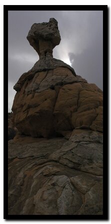
The area of White Pocket on the Paria Plateau in Northern Arizona is very impressive indeed! While many are lured and wait their turn to visit the infamous "Wave" in the North Coyote Buttes, the "White Pocket" area to the east is seldom visited. Maybe because of its remoteness or the requirement of 4WD to access the area. The impressive White Pocket will fill the senses beyond imagination! The drive to the swirling, twisted, multicolored natural artwork is an adventure in its own right, and the exploration by foot is endless. Whether spending just a couple of hours or an entire weekend, "White Pocket" will surely become "top of the top" in the list of special places. This area has colors, shapes and textures that are hard to beat, but remember that it is an extremely fragile environment and the utmost care should be taken to preserve this place. Tread lightly and make it a point to see if you can leave the area without anyone ever having known that you were there. Stay on the slickrock when possible, but be careful not to snap off thin fins and don't trample the delicate vegetation between the small mounds of beautiful stone. This area should, and can be, saved for any and all that visit in the future.
White Pocket at a Glance Photo Album:White Pocket Photos Topo Map:White Pocket Map Day Hike: Yes Distance: 4 miles round trip. Average Hiking Time: 3 hours. Equipment: Sticky Rubber Hiking Shoes, 3 quarts of water per person, sun protective clothing, Map and compass (GPS optional). Difficulty: Moderate. Permits: Not required. Trailhead: Off Highway 89 between Page, AZ and Kanab, UT. South Coyote Buttes Area. Trailend: Same as trailhead. Trail Access: Year-round but if the road is wet or there is melting snow it could be impassable. A 4WD is required. Off the Beaten Path: Yes Best Season: This is a year-round as long as the road is drivable.
Directions to White Pocket
From Kanab, drive 40 miles east on Highway 89. The turn onto House Rock Valley Road is located on the south side of the road (right side driving from Kanab). It is located between mile markers 25 and 26, before a sweeping left hand curve in the road, prior to a guard rail protecting the curve. Slow down and turn right just before the guard rail. This north-south running road is House Rock Valley Road. The road soon becomes dirt and may be impassible if wet. Continue past the Wirepass Trailhead (8.4 miles from Highway 89) to the Utah - Arizona state line. This is the border of the Grand Staircase-Escalante National Monument in Utah and the Vermillion Cliffs National Monument in Arizona. Keep driving south for another 8.1 miles past the Wire Pass Trailhead and look for the dirt road that turns left and to Lone Tree Reservoir. At this point there are two options to arrive at Poverty Flat. Poverty Flat is the junction to the east which is necessary to locate to continue further to either Cottonwood Spring (South Coyote Buttes) or White Pocket even further to the east.
Turn left at Lone Tree Reservoir and follow the main, sandy 4WD road to the east for 2.5 miles to the Paw Hole trailhead. Beyond Paw Hole the road becomes even deeper sand and may require tire deflation to prevent becoming stuck. The next 3 miles to the Windmill at Poverty Flat Ranch is deep sand and quite rugged in places. The road will pass through two gates. Close the gates after passing through them.
Alternative route to the Poverty Flat Ranch and Windmill Intersection:
At the Lone Tree Reservoir/ House Rock Valley Road Intersection you may opt to continue another 4 miles to the south on House Rock Valley Road to the road intersection 1017. Turn left (east) on 1017 and then travel 3 miles east to the junction bearing north-east and another 3 miles to Red Pocket. Traveling north-east for another 2.5 miles puts you at the Ranch and Windmill, and the junction to either Cottonwood Spring or White Pocket. This option of driving is longer, but does not require 4WD until after the Windmill.)
Once at the Windmill, travel northeast passing the windmill just on your left and a group of buildings on your right. The road now becomes quite sandy as it ascends a hill, toward a large water tank resting on a knoll 100 yards away. Be sure to keep up momentum and follow this sandy road to the east and then north for 1.8 miles until it arrives at a corral and fence. At this point the road will turn right and follow alongside the fence for a short time and continues east for 2.8 miles and then steers northeast for another 1.5 miles and ends in a very sandy area by a lone juniper tree. This is the parking area and trailhead. "White Pocket" monolith will have been visible during the drive at various times, and at the trailhead/parking area it is just a half mile to the west. There is no formal trail established, but it will soon be evident that wandering and exploring is the main fare. Immediately from arriving, and walking toward "White Pocket" the slickrock formations will lure and amaze with the unique colors and texture. Take time to look over the extensive formations and then maybe drop down into the valley below and head for a circumnavigation of the "White Pocket" monolith to the west? There is much to see, but remember to tread lightly and preserve the landscape as you found it.
Paria Canyon Directions
From Mount Carmel Junction, drive 17 miles to Kanab. Leave Kanab, drive 40 miles east on US Highway 89. The turn-off is located on the south (right side coming from Kanab) side of the road. Its between mile markers 25 and 26, at a curve in the road, at the end of a guard rail. Turn at the unmarked dirt road. This is House Rock Road. Follow the road to your preferred trailhead. Directions to the Wave
White Pocket - Paria Canyon
Lodging and services are available on the gorgeous east side of Zion National Park, where guests are close to Zion National Park (12 miles), Bryce Canyon National Park (60 miles), Cedar Breaks National Monument (45 miles), Coral Pink Sand Dunes (12 miles), and the North Rim of the Grand Canyon (85 miles). It's where city traffic is absent and the skies are bright and clean.
GPS Coordinates WGS84 Datum
House Rock Valley Road and
Lone Tree Reservoir Intersection
36°54.876 N
112°03.079 W
Paw Hole Trailhead and Parking
(South Coyote Buttes Permit Area)
36°55.394 N
112°01.080 W
Gate 1
36°55.501 N
112°00.369 W
Gate 2
36°55.613 N
112°00.197 W
Windmill at Poverty Flat Ranch
36°55.561 N
111°57.920 W
Corral at
Fence Line
36°56.569 N
111°56.713 W
Arch
36°56.221 N
111°55.497 W
White Pocket
Parking
and Trailhead
36°57.328 N
111°53.734 W
Optional entrance
to Poverty Flat
Windmill on road 1017
36 51.699 N
112 03.781 W
Stateline Campground - between Arizona and Utah
It's 10-miles to the Stateline Campground from US Highway 89. There are only 4 spots, so if you want to camp get a spot early. It's first come first use. Two of the camp sights are in Utah and two are in Arizona. There is no water, but there are vault toilets.
Coyote Buttes Special Permit Offices Arizona Strip Field Office: 345 East Riverside Drive St. George, Utah 84790 435.688.3200 Kanab Office: 318 N 100 E Kanab, Utah 84741 435.644.4600. Paria Contact Station: Located south of US Highway 89 between mile post 21 and 22,
between Kanab and Page, Arizona.
Paria Canyon Wilderness contains Coyote Buttes Special Management Area which was made popular by the Wave. The sandstone buttes sit at the bottom of Utah's Grand Staircase-Escalante National Monument and the upper section of Arizona's Paria Canyon Wilderness.
Mileage from
Mt. Carmel Jct.
Zion National Park 12
Bryce Canyon 60
Grand Canyon 85
Cedar Breaks 45
Grand Staircase 9
Dixie Forest 22
Sand Dunes 11
Coyote Butte 57
Red Canyon 47
Tuweep 90
Stay in the heart of the parks, Mount Carmel Junction, and visit the treasures of the Southwest and Utah.
This is my new favorite quote:
"I don't know who Mary Cisneros is, but I mean zionnational-park.com
It's a better site than the NPS's anyway."
Written by the authors of the book: Favorite Hikes in and around Zion National Park


 Paria Canyon - White Pocket
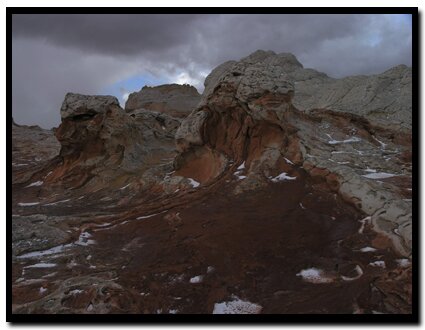 Directions to White Pocket
 Alternative route to the Poverty Flat Ranch and Windmill Intersection:

 Corral at