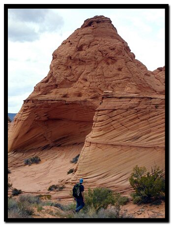
The fragile and more remote South Coyote Buttes are as magnificent as the north, but lacking the popularity of "The Wave." South Coyote Butte formations are fragile, but the Paw Hole formations are a little hardier than the Cottonwood Teepees.
Paw Hole at a Glance Photo Album:South Coyote Buttes Pictures Topo Map:Paw Hole Topo Map Day hike: Yes. No overnight camping inside the hiking route. Trail Distance: 3 miles Average hiking time: 4 hours Accessible Trail: No. Usage: Limited to 20 people per day. Group size 6 persons. The road is impassable if wet. Difficulty: Moderate Sun Exposure: Full sun. There is no shade and the dark red rock and sand will reflect the sun and amplify the effects of heat, Carry at least 1 gallon of water per person in the summer. Permits: Required. Limited to 6 in a group. Day use only. Apply for an online permit or pick them up in person. Choose Coyote Butte South. Cost is per person. Kanab BLM Office: 318 N 100 E 435.644.4600 Paria BLM office 4 miles east of the Wire Pass turn-off. Trail Conditions: A high clearance vehicle is needed. A 4WD is suggested to get to the trailhead, but in good conditions the road may be passable in a 2WD. The sandy road is impassable if wet. Trailend: Same as trailhead Best Season: Spring and Fall. Hot in the summer, when the weather cooperates this is a good winter hike. Off the beaten path: Yes Starting Elevation: 5950' Highest Elevation: 6350' Elevation: gain 400' - loss 400' Restrooms: Vault toilet at the Wire Pass Trailhead and the State line Campground.
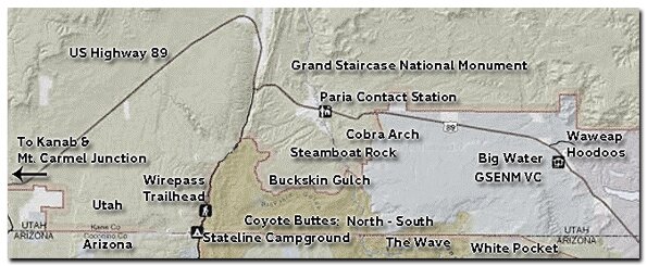
House Rock Road - Continue past the Wire Pass Trailhead (8.3 miles) to the Utah - Arizona State line This is the border of the Grand Staircase Escalante National Monument in Utah and the Vermillion Cliffs National Monument in Arizona. Continue on House Rock Road. The next trailhead is unmarked but it is the Notch, an alternate route into "The Wave." The turn-off for South Coyote Buttes is also unmarked, but it's 17 miles from Highway 89 and its on the left side of the road. If you get to the Honeymoon Trail sign at 18 miles you have gone too far.
Paw Hole Exploration - A high clearance vehicle is required for this sometimes rocky but very sandy road and a 4WD is suggested. The first landmark is Lone Tree Reservoir at .2 miles. Don't expect water there often, but there is one lone Juniper tree at the usually dry hole. Shortly after is a welcome sign to the Vermillion Cliffs National Monument, then farther down the road is a sign for Coyote Buttes. The parking area for the Paw Hole route is 2.5 miles.
Park and go through the fence, headed north - northeast toward the hoodoos and buttes. There is no established trail, instead this route is more of an exploration around the hoodoos. From the trailhead, the southeast side of the trailhead offers some nice formations.
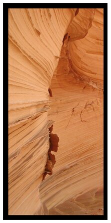
Look for the small arch, at the top of the first hoodoo that is seen from the parking area. The climb is fourth class, and not recommended due to the fragile rock. Toward the northeast is a beautiful sandstone bowl located at the end of the dunes. Again, do not climb the fragile rock. Hike around the bowl, walking along the sand toward the hoodoos to the northeast. After heading west, House Rock Road and more hoodoos become visible. Head toward the rock formations. On the western slope, to the north, the sandstone gets really interesting. Locate the angular shaped grotto. Inside are fragile fins and soft sand. Explore the area around the grotto before hiking in the direction of the parking area. If you take the route on the western edge of the butte, there is some 4th class climbing at the bottom of the cliff.
Paria Canyon Directions
From Mount Carmel Junction, drive 17 miles to Kanab. Leave Kanab, drive 40 miles east on US Highway 89. The turn-off is located on the south (right side coming from Kanab) side of the road. Its between mile markers 25 and 26, at a curve in the road, at the end of a guard rail. Turn at the unmarked dirt road. This is House Rock Road. Follow the road to your preferred trailhead. Directions to the Wave
Note the delicate rock here
Lodging and services are available on the gorgeous east side of Zion National Park, where guests are close to Zion National Park (12 miles), Bryce Canyon National Park (60 miles), Cedar Breaks National Monument (45 miles), Coral Pink Sand Dunes (12 miles), and the North Rim of the Grand Canyon (85 miles). It's where city traffic is absent and the skies are bright and clean.
Stateline Campground - between Arizona and Utah
It's 10-miles to the Stateline Campground from US Highway 89. There are only 4 spots, so if you want to camp get a spot early. It's first come first use. Two of the camp sights are in Utah and two are in Arizona. There is no water, but there are vault toilets.
Coyote Buttes Special Permit Offices Arizona Strip Field Office: 345 East Riverside Drive St. George, Utah 84790 435.688.3200 Kanab Office: 318 N 100 E Kanab, Utah 84741 435.644.4600. Paria Contact Station: Located south of US Highway 89 between milepost 21 and 22,
between Kanab and Page, Arizona.
Paria Canyon Wilderness contains Coyote Buttes Special Management Area which was made popular by the Wave. The sandstone buttes sit at the bottom of Utah's Grand Staircase-Escalante National Monument and the upper section of Arizona's Paria Canyon Wilderness.
Mileage from
Mt. Carmel Jct.
Zion National Park 12
Bryce Canyon 60
Grand Canyon 85
Cedar Breaks 45
Grand Staircase 9
Dixie Forest 22
Sand Dunes 11
Coyote Butte 57
Red Canyon 47
Tuweep 90
Stay in the heart of the parks, Mount Carmel Junction, and visit the treasures of the Southwest and Utah.


 Paria Canyon: South Coyote Buttes