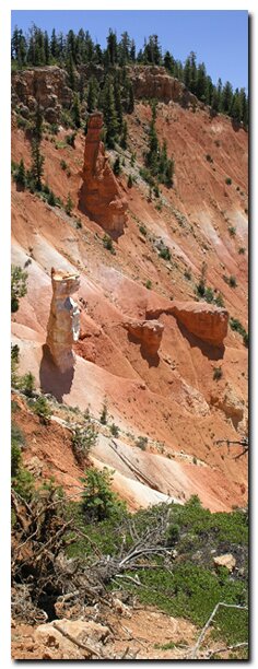
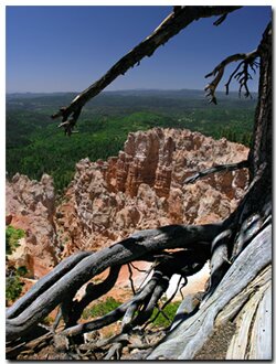
This section of the Virgin River Rim Trail is from Dry Valley (Cow Lake) to Strawberry Ridge (Strawberry Point). Along the trail enjoy a variety of evergreen trees including the earths oldest living thing - the Bristlecone pine tree and Cedar Breaks-like amphitheaters. This moderately difficult route is done as a one way hike with a shuttle setup. A section of the trail may be done as an out and back thus eliminating the need of a shuttle vehicle. The trail follows the Virgin River Rim in Dixie National Forest and affords views to the south of the expansive Zion National Park. The headwaters of the Virgin River are formed by Cascade Falls (Navajo Lake) and watershed of the southern slopes on this ridge. The trail generally travels in an west to easterly direction. At an average elevation of 8800', and traveling as high as 9200', the temperatures are a welcome reprieve in the summertime from the lower elevation hikes in the Southwest desert. As a one way hike, the distance is 8.25 miles, but some of the more interesting landmarks can be arrived at in about 3.5 miles, then by turning back to the trailhead, a total distance of 7 miles is covered and eliminates a car shuttle setup.
Virgin River Rim Trail at a Glance Photo Album:Virgin River Rim Photos Trail Maps:Virgin River Rim Map Day Hike: Yes. Distance: 8.25 Miles Average Hiking Time: 6 hours Equipment: The best map to purchase for this hike is the "Cedar Mountain/ Pine Valley Mountain" National Geographic-Trails Illustrated. Difficulty: Moderate hiking, but the last section back to your vehicle is steep after hiking all day. Trailhead: Cascade Falls Trailhead near Navajo Lake Trailend: Strawberry Ridge Trail Access: Dirt roads can be impassable if wet. Elevation at Trailhead: 9000' Elevation at Trailend: 9000' Off the Beaten Path: Yes Best Season: Spring, Fall and Summer.
Shuttle Setup - First Car Trailend
To station a car shuttle at the trailend (Strawberry Ridge) travel 7.75 miles west on U-14 from the Highway 89 junction or 14.75 miles east from the junction of Highway 14 and Highway 148 (Road to Cedar Breaks). Arriving at Strawberry Creek (valley with homes to the south) turn to the south, traveling the dirt (very dusty) road for the next 8.5 miles to the Virgin River Rim Trail which is located on Strawberry Ridge. Park one vehicle at the trailend. To avoid hiking the last uphill section which could be considered strenuous after hiking all day, park at the first Virgin Rim Trail sign seen. However there is not much parking in this area.
Second Car - Trailhead - Travel back to Highway 14 and turn left (west) and travel 5 miles passing Duck Creek Village to a ranger station and visitor center on the left . Turn left and pass the ranger station and follow the dirt road 1.75 miles to the west edge of Dry Valley. Turn left on the gravel road and travel another 1.5 miles to the parking area and trailheads for Cascade Falls and the Virgin River Rim Trail.
Utah's Dixie National Forest: Cedar Mountain
Cedar Breaks National Monument is surrounded by Utah's Dixie National Forest. From Mt. Carmel Junction, drive north on US-89 to the junction with U-14. SR-14 is known as Cedar Mountain which is the scenic byway to travel to Cedar Breaks. Once on Cedar Mountain, travel through the beautiful forest, and then turn at the signed highway to Cedar Breaks - U-148. It's 22 miles from Mt. Carmel Junction to boundary of Dixie National Forest and 45 miles to Cedar Breaks.
Utah's Dixie National Forest: Red Canyon Red Canyon is a unique part of Dixie National Forest that is not only traveled through on the way to Bryce Canyon, but it has eroded hoodoos like Bryce Canyon and Cedar Breaks. It is found along U-12
Lodging and services are available on the gorgeous east side of Zion National Park, where guests are close to Zion National Park (12 miles), Bryce Canyon National Park (60 miles), Cedar Breaks National Monument (45 miles), Coral Pink Sand Dunes (12 miles), and the North Rim of the Grand Canyon (85 miles). It's where city traffic is absent and the skies are bright and clean.
Virgin Rim Trail - Cascade Falls Trailhead to Strawberry Ridge
The trailhead for the Virgin River Rim Trail traveling east back to Strawberry Point is on the south side of the parking lot. Initially the trail switchbacks up the hillside through a forest of Fir and Aspen to arrive at the rim in just a half mile. Soon the rim overlooks the multitudes of drainages that make up the watershed for the North Fork of the Virgin River. Continual water flow coming from Cascade Falls and Navajo Lake to the north and west are the main source feeding the Virgin River. This hike also affords close up views of Bristlecone pines intermittently rising from the forest floor alongside the trail. At 1.6 miles the trail veers from the rim for a short time and once again winds into the forest. The hiking thus far has been fairly level except for the gain of the rim in the beginning. At mile 1.8 the trail crosses a service road and signs keep the trail evident. 2.75 miles brings more road crossings and at 3 miles is Lars Fork. Just another half mile farther brings the trail back to the rim and to a amphitheater with interesting hoodoos. Locals call the amphitheater the "Cats Den. One prominent hoodoo at the bottom looks like a cat. By looking further down into the alcove a window also becomes apparent. This area is definitely one of, if not the highlight of the hike. This is a good place to stop and have a snack and soak in the beauty of the limestone formations and the grand views to the south of Zion National Park.
The next 3.75 miles on the well groomed trail meanders back and forth through the delightful forest and sporadically touches the rim until it finally dives into and follows a drainage to the development below in Strawberry Creek. Crossing the road and tiptoeing across a marshy area of Strawberry Creek soon finds the trail underfoot again and the uphill 1 mile through the woods. If you stationed a vehicle here you are done. If you parked at the upper sign, hoof up the hill to get in that last bit of exercise. Crossing the road at the top of the ridge means that the shuttle vehicle and cold drinks await just around the next corner.
Mileage from
Mt. Carmel Jct.
Zion National Park 12
Bryce Canyon 60
Grand Canyon 85
Cedar Breaks 45
Grand Staircase 9
Dixie Forest 22
Sand Dunes 11
Coyote Butte 57
Red Canyon 47
Tuweep 90
Stay in the heart of the parks, Mount Carmel Junction, and visit the treasures of the Southwest and Utah.
This is my new favorite quote:
"I don't know who Mary Cisneros is, but I mean zionnational-park.com
It's a better site than the NPS's anyway."
Written by the authors of the book: Favorite Hikes in and around Zion National Park
Contact Mary to report errors: