border

All American Highway - Utah Highway 12

Why drive the hectic freeways when it takes about the same time to get to the Southwestern parks, Bryce Canyon and Zion National Park, on beautiful scenic byways? Experience geological wonders, beauty galore and small-town charm.

Utah Scenic Byway 12 - All American Highway

Scenic Byway 12, is 123 miles long and runs west to east. The road begins off US-89, south of Panguitch, Utah. The highway passes through the northern edge of Bryce Canyon National Park as well as some incredible scenery. The road has the prestige of being named an "All American Highway," and has been ranked the "second most scenic road in the country," by Car and Driver magazine. The trip through Red Canyon and Bryce Canyon is one not to miss. Scenic Byway 12 is part of the magnificent Route-89 Vacation Tour. Highway 12 meets up with the Mt. Carmel Scenic Byway, which joins with highway 9 to Zion National Park. It also hooks up with the Grand Staircase Escalante National Monument back road - Skutumpah. map

Connecting the National Parks with beauty and adventure

Utah State Road 9 - thru Zion Park

Utah US-89 -connects with SR-9 from
Zion National Park in Mt. Carmel Jct.

Utah State Road 14 is Cedar Mountain.

Utah State Road 148 - to Cedar Breaks

Arizona 89A and SR-67 to Grand Canyon

Southern Utah Backways

Scenic Byways of southern Utah

Bryce Canyon Map Coral Pink Sand Dunes Map Grand Staircase-Escalante Map Bryce Canyon National Park Grand Canyon National Park, Arizona - North Rim Map Red Canyon, Dixie National Forest, Utah Lodging: Zion National Park Zion National Park Cedar Breks National Monument, Utah Dixie National Forest: Cedar Mountain Zion National Park Map Coral Pink Sand Dunes Map Zion National Park Lodging Cedar Breaks and Dixie National Forest Map Bryce Canyon and Red Canyon Map Grand Staircase-Escalante Map Zion National Park Map Coral Pink Sand Dunes Map Zion National Park Lodging Cedar Breaks and Dixie National Forest Map Grand Staircase-Escalante Map Bryce Canyon National Park Zion National Park Map Coral Pink Sand Dunes Map Zion National Park Lodging Cedar Breaks and Dixie National Forest Map Bryce Canyon and Red Canyon Map Grand Staircase-Escalante Map Zion National Park Map Coral Pink Sand Dunes Map Zion National Park Lodging Cedar Breaks and Dixie National Forest Map Bryce Canyon and Red Canyon Map Grand Staircase-Escalante Map Coral Pink Sand Dunes Map Grand Staircase-Escalante Map Bryce Canyon National Park Grand Canyon National Park, Arizona - North Rim Map Red Canyon, Dixie National Forest, Utah Lodging: Zion National Park Zion National Park Cedar Breks National Monument, Utah Dixie National Forest: Cedar Mountain Zion National Park Map Coral Pink Sand Dunes Map Zion National Park Lodging Cedar Breaks and Dixie National Forest Map Bryce Canyon and Red Canyon Map Grand Staircase-Escalante Map Zion National Park Map Coral Pink Sand Dunes Map Zion National Park Lodging Cedar Breaks and Dixie National Forest Map Grand Staircase-Escalante Map Bryce Canyon National Park Zion National Park Map Coral Pink Sand Dunes Map Zion National Park Lodging Cedar Breaks and Dixie National Forest Map Bryce Canyon and Red Canyon Map Grand Staircase-Escalante Map Zion National Park Map Coral Pink Sand Dunes Map Zion National Park Lodging Cedar Breaks and Dixie National Forest Map Bryce Canyon and Red Canyon Map Grand Staircase-Escalante Map Coral Pink Sand Dunes Map Grand Staircase-Escalante Map Bryce Canyon National Park Grand Canyon National Park, Arizona - North Rim Map Red Canyon, Dixie National Forest, Utah Lodging: Zion National Park Zion National Park Cedar Breks National Monument, Utah Dixie National Forest: Cedar Mountain Zion National Park Map Coral Pink Sand Dunes Map Zion National Park Lodging Cedar Breaks and Dixie National Forest Map Bryce Canyon and Red Canyon Map Grand Staircase-Escalante Map Zion National Park Map Coral Pink Sand Dunes Map Zion National Park Lodging Cedar Breaks and Dixie National Forest Map Grand Staircase-Escalante Map Bryce Canyon National Park Zion National Park Map Coral Pink Sand Dunes Map Zion National Park Lodging Cedar Breaks and Dixie National Forest Map Bryce Canyon and Red Canyon Map Grand Staircase-Escalante Map Zion National Park Map Coral Pink Sand Dunes Map Zion National Park Lodging Cedar Breaks and Dixie National Forest Map Bryce Canyon and Red Canyon Map Grand Staircase-Escalante Map Coral Pink Sand Dunes Map Grand Staircase-Escalante Map Bryce Canyon National Park Grand Canyon National Park, Arizona - North Rim Map Red Canyon, Dixie National Forest, Utah Lodging: Zion National Park Zion National Park Cedar Breks National Monument, Utah Dixie National Forest: Cedar Mountain Zion National Park Map Coral Pink Sand Dunes Map Zion National Park Lodging Cedar Breaks and Dixie National Forest Map Bryce Canyon and Red Canyon Map Grand Staircase-Escalante Map Zion National Park Map Coral Pink Sand Dunes Map Zion National Park Lodging Cedar Breaks and Dixie National Forest Map Grand Staircase-Escalante Map Bryce Canyon National Park Zion National Park Map Coral Pink Sand Dunes Map Zion National Park Lodging Cedar Breaks and Dixie National Forest Map Bryce Canyon and Red Canyon Map Grand Staircase-Escalante Map Zion National Park Map Coral Pink Sand Dunes Map Zion National Park Lodging Cedar Breaks and Dixie National Forest Map Bryce Canyon and Red Canyon Map Grand Staircase-Escalante Map Zion National Park Map Coral Pink Sand Dunes Map Zion National Park Lodging Cedar Breaks and Dixie National Forest Map Bryce Canyon and Red Canyon Map Grand Staircase-Escalante Map
Red Canyon - Scenic Byway 12

If traveling to Bryce Canyon National Park, plan to spend a little time in Dixie National Forest's, Red Canyon. There are fun trails, a delightful paved bike path, the Red Canyon Visitor Center and great photo opportunities.

Red Canyon Bike Trails
For bicycle enthusiasts U-12 is a dream. Red Canyon offers a paved bike path that parallels Scenic Byway 12.

Bryce Canyon
Bryce Canyon is located 9 miles from Red Canyon. Pass through Red Canyon and continue on U-12 to U-63, turning south on U-63. The entrance to Bryce Canyon is only a couple of miles away, after the turn onto U-63.


Directions to Bryce Canyon

From Salt Lake City: Travel south on Interstate 15 past Beaver to UT 20. Exit on UT 20. Turn south on UT 89 and travel past Panguitch. Follow UT 89 to UT 12. Travel along UT 12 through Red Canyon to Bryce Canyon. Turn south on UT 63 to enter the park.
From Las Vegas: Travel Interstate 15 past St. George to Exit 16. Drive through Hurricane, Utah. Follow Utah Highway 9 through Hurricane and to the only stop light in LaVerkin. Turn right at the stop light. Continue on Highway 9 to the south entrance of Zion National Park. Drive through Zion to the junction of UT 9 and US 89 at Mt. Carmel Jct. Turn north on UT 89, then exit on UT 12. Follow UT 12 through Red Canyon, turning south on UT 63 to enter Bryce Canyon.

Bryce Canyon Road Map - Bryce Canyon Trail Map

Zion National Park Maps
 
Utah Highway 12 leading to Bryce Canyon National Park

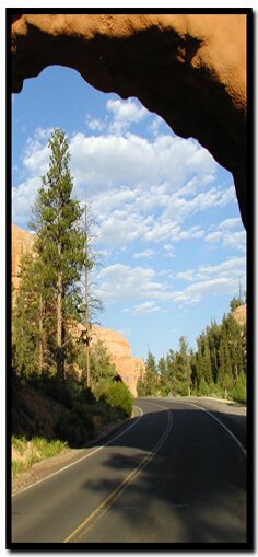
There are two fun little tunnels along SR-12 in Red Canyon. This "mini-Bryce Canyon" is part of Dixie National Forest, rather than a National Park like Bryce Canyon. It's a great place for horse and bike rides.


Lodging Zion National Park
Lodging Zion National ParkLodging and services are available on the gorgeous east side of Zion National Park, where guests are close to Zion National Park (12 miles), Bryce Canyon National Park (60 miles), Cedar Breaks National Monument (45 miles), Coral Pink Sand Dunes (12 miles), and the North Rim of the Grand Canyon (85 miles). It's where city traffic is absent and the skies are bright and clean.

 
Book: Favorites hike in and around Zion National Park - including Bryce CanyonBryce Canyon - Bryce Canyon is located 9 miles from Red Canyon. Pass through Red Canyon and continue on U-12 to U-63, turning south on U-63. The entrance to Bryce Canyon is only a couple of miles away, after the turn onto U-63.

Mt. Carmel Scenic Byway - The Mt. Carmel Scenic Byway meets Scenic Byway 12 at the U-12 and US-89 junction. The byway runs 60 miles, beginning south of Panguitch and ending in East Zion, at the vacation community of Mt. Carmel Junction.


America the Beautiful Pass to all National Parks and Monuments


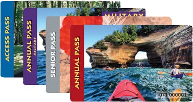
Consider buying the America the Beautiful Park pass. It will get you into Bryce Canyon National Park, Zion National Park, Grand Canyon National Park and all the US Federal Lands on your want to see list. The pass can be purchased online or at the gate of any of the parks. Help out your favorite park and buy the pass from them or speed up the lines to get into the parks and get yours ahead of time on the internet.


Web Southwest Parks


Share

Bryce Canyon National Park, Utah

Best Western
East Zion Lodge

Reservations
1.888.848.6358

Zion Park Lodging

Zion National Park Lodging

East Zion Lodge
Vacation House
Group Lodging
East Zion Golf
East Zion RV Park
Vacation Packages
Family Reunion
Bus Tours
Business Retreat

Mileage from
Mt. Carmel Jct.

Zion National Park 12
Bryce Canyon 60
Grand Canyon 85
Cedar Breaks 45
Grand Staircase 9
Dixie Forest 22
Sand Dunes 11
Coyote Butte 57
Red Canyon 47
Tuweep 90

Stay in the heart of the parks, Mount Carmel Junction, and visit the treasures of the Southwest and Utah.

Site Map
Site Map II
Site Map III

Bryce Canyon History

Bryce Canyon Geology

Bryce Canyon Fauna

Bryce Canyon Flora

Bryce Canyon Kids


This is my new favorite quote:
"I don't know who Mary Cisneros is, but I mean zionnational-park.com
It's a better site than the NPS's anyway."
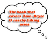
Written by the authors of the book: Favorite Hikes in and around Zion National Park
Contact Mary to report errors:
 
border

Zion History
Zion Landmarks
Zion Geology
Zion Geology II
Zion Geology III
Zion Fauna

Zion Rock Art

Disclaimer & Privacy Policy
All rights reserved © Copyright Zion National-Park  dot com
Do not use text, photos or maps without permission © Zion National-Park dot com
Contact the Author Mary Cisneros
Bryce Canyon Map Zion National Park Map - Overview of Zion