border

Cedar Breaks Hiking

Cedar Breaks offers three high country hiking trails, each giving a different perspective of the area. There are more hiking trails just outside of the monument and a few more in nearby Dixie National Forest.

Rim View
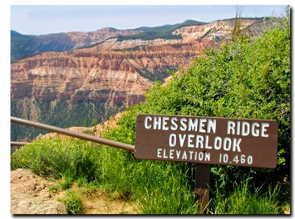
Look down into the amphitheater to see the amazing erosion of Cedar Breaks. Washes develop between rocks allowing water from rain and melting snow to run. The action of water and gravity can result in rock falling. In extreme cases, a layer can become saturated with enough water that the slope fails and the sediments slide as one section.

Alpine Pond
The Alpine Pond Trail travels through meadows of wildflowers and a sub-alpine forest to a spring-fed pond that sits in a sump. White and pale blue columbines peek from the dark vegetation around the pool in brilliant contrast to the green leaves. Aspen and fir frame the picturesque setting that wildlife frequents. The path leads past a volcanic rock area called the Talus Slope before looping back to the trailhead. There is an informative brochure available at the trailhead or at the Cedar Breaks Visitor Center that corresponds to the markers along the trail. About 30-million years ago, active volcano's erupted at Cedar Breaks sending hot ash across the land. The ash cooled to a reddish rock which is found along the trail.

Cedar Breaks National Park, Utah Coral Pink Sand Dunes Map Grand Staircase-Escalante Map Bryce Canyon National Park Grand Canyon National Park, Arizona - North Rim Map Red Canyon, Dixie National Forest, Utah Lodging: Zion National Park Zion National Park Cedar Breks National Monument, Utah Dixie National Forest: Cedar Mountain Zion National Park Map Coral Pink Sand Dunes Map Zion National Park Lodging Cedar Breaks and Dixie National Forest Map Bryce Canyon and Red Canyon Map Grand Staircase-Escalante Map Zion National Park Map Coral Pink Sand Dunes Map Zion National Park Lodging Cedar Breaks and Dixie National Forest Map Grand Staircase-Escalante Map Bryce Canyon National Park Zion National Park Map Coral Pink Sand Dunes Map Zion National Park Lodging Cedar Breaks and Dixie National Forest Map Bryce Canyon and Red Canyon Map Grand Staircase-Escalante Map Zion National Park Map Coral Pink Sand Dunes Map Zion National Park Lodging Cedar Breaks and Dixie National Forest Map Bryce Canyon and Red Canyon Map Grand Staircase-Escalante Map Zion National Park Map Coral Pink Sand Dunes Map Zion National Park Lodging Cedar Breaks and Dixie National Forest Map Bryce Canyon and Red Canyon Map Grand Staircase-Escalante Map Coral Pink Sand Dunes Map Grand Staircase-Escalante Map Bryce Canyon National Park Grand Canyon National Park, Arizona - North Rim Map Red Canyon, Dixie National Forest, Utah Lodging: Zion National Park Zion National Park Cedar Breks National Monument, Utah Dixie National Forest: Cedar Mountain Zion National Park Map Coral Pink Sand Dunes Map Zion National Park Lodging Cedar Breaks and Dixie National Forest Map Bryce Canyon and Red Canyon Map Grand Staircase-Escalante Map Zion National Park Map Coral Pink Sand Dunes Map Zion National Park Lodging Cedar Breaks and Dixie National Forest Map Grand Staircase-Escalante Map Bryce Canyon National Park Zion National Park Map Coral Pink Sand Dunes Map Zion National Park Lodging Cedar Breaks and Dixie National Forest Map Bryce Canyon and Red Canyon Map Grand Staircase-Escalante Map Zion National Park Map Coral Pink Sand Dunes Map Zion National Park Lodging Cedar Breaks and Dixie National Forest Map Bryce Canyon and Red Canyon Map Grand Staircase-Escalante Map Zion National Park Map Coral Pink Sand Dunes Map Zion National Park Lodging Cedar Breaks and Dixie National Forest Map Bryce Canyon and Red Canyon Map Grand Staircase-Escalante Map Zion National Park Map Coral Pink Sand Dunes Map Zion National Park Lodging Cedar Breaks and Dixie National Forest Map Bryce Canyon and Red Canyon Map Grand Staircase-Escalante Map Favorite Hikes in and around Zion National ParkSpectra Point Trail
This 2 mile round trip hike has some elevation changes that make it a moderate hike. The hike begins at the Spectra Point amphitheater, near the toll booth, and follows its southern rim climbing 142' to the water towers and the site of the old Cedar Breaks Lodge and then drops 207' to Spectra Point. Spectra Point offers an impressive view of hoodoos. Along this trail, notice the different hues of color in the rock formations. On one side of the trail are hoodoos and on the other is a beautiful meadow of wildflowers and fir trees. The Colorado Columbine adds a subtle beauty to this hike. A close up of the white cap rock at Cedar Breaks is seen as well as ancient Bristlecone pines. One Bristlecone pine at Spectra point is 1,700 years old!

Ramparts Trail
The 4 mile round trip trail shares the first mile of the trip with the Spectra Point Trail.  Follow the beaten path to Spectra Point where the beaten path will turn west to continue another mile and descends 333' to the second view point. This route follows the rim and allows hikers to look back toward the view points along the Cedar Breaks scenic drive. There is a refreshing creek, Shooting Star Creek, that runs along part of the trail, but breaks away, dropping off the edge of the rim about a half-mile past the Ramparts View Point.

Directions to Cedar Breaks

U-148 Closure Dates. U-148 to Cedar Breaks closes in the winter due to snow depth.

From Las Vegas: Take I-15 north to Cedar City. Take U-14 east from Cedar City to U-148 and turn left to Cedar Breaks.
From Arizona: Take US-89 north through Mount Carmel Junction and turn west on U-14. Turn right at U-148 to Cedar Breaks.
From Salt Lake City: Take I-15 south, exit at Parowan. Take U-143 to Cedar Breaks.
From Mount Carmel Junction: Take US-89 north to U-14. Follow U-14 to U-148 and Cedar Breaks.

Cedar Breaks Road Map - Cedar Mountain Map

Zion National Park Maps Map: Cedar Mountain - Dixie National Forest Southern Utah map Zion National Park Map - Overview of Zion Utah State Road 14 Utah State Road 148
 
Cedar Breaks Hiking

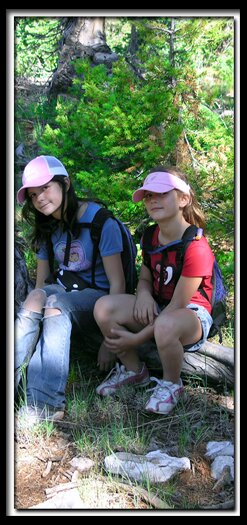
Summer and Kyra Milligan take a rest while hiking in the Cedar Breaks area. This is a great place to introduce kids to hiking. The Alpine Pond Trail is an excellent family hike at Cedar Breaks.


Lodging Zion National Park
Lodging Zion National ParkLodging and services are available on the gorgeous east side of Zion National Park, where guests are close to Zion National Park (12 miles), Bryce Canyon National Park (60 miles), Cedar Breaks National Monument (45 miles), Coral Pink Sand Dunes (12 miles), and the North Rim of the Grand Canyon (85 miles). It's where city traffic is absent and the skies are bright and clean.


Trails Near Cedar Breaks

Shooting Star Creek and Bartizan Arch - Travel beyond Ramparts Trail to the little known Shooting Star Waterfall and the impressive Bartizan Arch.

Below the Rim at Cedar Breaks - This route takes hikers to the bottom of the impressive Cedar Breaks hoodoos.  This 10 mile trail is best done with a car shuttle.

Cascade Falls - The Cascade Falls trail is a half-mile hike, with few elevation changes, overlooking the southern edge of the Markagunt Plateau. The trail ends at a rocky ledge with water tumbling down from a limestone hole. Cascade Falls is the North Fork of the Virgin River.

Bristlecone Pine Trail - This is an easy .77 mile hike to a view of Zion National Park in the distance. The trail ends in a grove of magnificent bristlecone pines. Look for the trailhead immediately west of the turn-off to Cedar Breaks. An interesting tidbit is that the bristlecone pines are the oldest living things on earth.

Ashdown Gorge -  Rattlesnake Creek Route
This is a 10 mile hike. The time it takes to hike depends on the water levels and how many side canyons you explore.  Plan on 6 hours to a full day of hiking. With so much to see and explore the hike is often stretched out to a 2 or 3 day backpack. The hike is one way and two cars are needed or hitchhike back to your vehicle.

Cedar Breaks Bottoms - This route takes backpackers to the bottom of the impressive Cedar Breaks hoodoos and allows wilderness camping. 

Twisted Forest Trail
- This 2 mile trail (roundtrip) is located just past Cedar Breaks National Monument. Continue on SR 143 toward Brian Head Ski Resort to find the trailhead. This trail can be hiked or biked. The path meanders past twisted Bristlecone Pine trees, with cairns to mark the way. At the end of the trail is a nice view of of the Ashdown Gorge Wilderness and the Cedar Breaks amphitheater.

Utah's Dixie National Forest: Cedar Mountain
Cedar Breaks National Monument is surrounded by Utah's Dixie National Forest. From Mt. Carmel Junction, drive north on US-89 to the junction with SR-14. SR-14 is known as Cedar Mountain which is the scenic byway to travel to Cedar Breaks. Once on Cedar Mountain, travel through the beautiful forest, and then turn at the signed highway to Cedar Breaks - SR-148. It's 22 miles from Mt. Carmel Junction to boundary of Dixie National Forest and 45 miles to Cedar Breaks.

Utah's Dixie National Forest: Red Canyon
Red Canyon is a unique part of Dixie National Forest that is not only traveled through on the way to Bryce Canyon, but it has eroded hoodoos like Bryce Canyon and Cedar Breaks. It is found along Scenic Byway 12.


Web Southwest Parks


Share

Cedar Breaks National Monument, Utah

Best Western
East Zion Lodge

Reservations
1.888.848.6358

Zion Park Lodging

Zion National Park Lodging

East Zion Lodge
Vacation House
Group Lodging
East Zion Golf
East Zion RV Park
Vacation Packages
Business Retreat

Mileage from
Mt. Carmel Jct.

Zion National Park 12
Bryce Canyon 60
Grand Canyon 85
Cedar Breaks 45
Grand Staircase 9
Dixie Forest 22
Sand Dunes 11
Coyote Butte 57
Red Canyon 47
Tuweep 90

Stay in the heart of the parks, Mount Carmel Junction, and visit the treasures of the Southwest and Utah.

Site Map
Site Map II
Site Map III


Hiking Trails
Bartizan Arch
Spectra Point Trail
Ramparts Trail

Easy Trails
Cascade Falls
Bristlecone Pine
Alpine Pond

Cedar Breaks info
Visitor Center
Fees and passes
Ranger programs
Kid activities
Geology
History
Fauna
Flora

Cedar Breaks maps

Park map
Road map

This is my new favorite quote:
"I don't know who Mary Cisneros is, but I mean zionnational-park.com
It's a better site than the NPS's anyway."
Written by the authors of the book: Favorite Hikes in and around Zion National Park
Contact Mary to report errors:
 
border

Zion History
Zion Landmarks
Zion Geology
Zion Geology II
Zion Geology III
Zion Fauna

Zion Rock Art

Disclaimer & Privacy Policy
All rights reserved © Copyright Zion National-Park  dot com
Do not use text, photos or maps without permission © Zion National-Park dot com
Contact the Author Mary Cisneros
Bryce Canyon Map Zion National Park Map - Overview of Zion