|
|
 |
|||
|
Cedar Breaks Lodging Camping SR 148 SR-14 Hike Backpacking Vacation DNF Pictures Area Weather |
||||

|
|||||||||||||

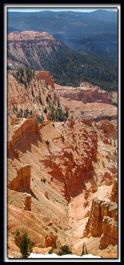
 Hoodoos at Cedar Breaks
Directions to Cedar BreaksU-148 Closure Dates. U-148 to Cedar Breaks closes in the winter due to snow depth. From Las Vegas: Take I-15 north to Cedar City. Take U-14 east from Cedar City to U-148 and turn left to Cedar Breaks. Cedar Breaks Road Map - Cedar Mountain Map 
|
|
|||
|
|
||||

Where does the beautiful coral color at Cedar Breaks come from?
Rock formations dating from the late Mesozoic and Early Cenozoic periods include dakota, tropic shale, straight cliffs and Cedar Break's dominant soft, calcareous claron formation. Claron is a colorful combination of pinks and oranges caused by trace amounts of iron oxide. The white formations you see in the park are lacking the iron oxide. The pink limestone from the claron formation, with its iron and manganese oxides is responsible for the reds and pinks that we see in the rocks today. Comparing the Claron of Cedar Breaks and Bryce Canyon shows that the Claron of Cedar Breaks is thicker and more colorful. Cedar Break's smaller amphitheater is three miles wide and two thousand feet deep.
What is the elevation at Cedar Breaks?
Cedar Breaks sits at 10,350' and nearby Bryce Canyon ranges between 6,600' to 9,100' elevation. Zion National Park is the warmest of the Southwest National Parks and Monuments with an elevation range of 3,700' to 8,726'. Cedar Breaks is the coolest with Bryce Canyon being a close second.
Utah's Dixie National Forest: Cedar Mountain
Cedar Breaks National Monument is surrounded by Utah's Dixie National Forest. From Mt. Carmel Junction, drive north on US-89 to the junction with SR-14. SR-14 is known as Cedar Mountain which is the scenic byway to travel to Cedar Breaks. Once on Cedar Mountain, travel through the beautiful forest, and then turn at the signed highway to Cedar Breaks - SR-148. It's 22 miles from Mt. Carmel Junction to boundary of Dixie National Forest and 45 miles to Cedar Breaks.
Utah's Dixie National Forest: Red Canyon
Red Canyon is a unique part of Dixie National Forest that is not only traveled through on the way to Bryce Canyon, but it has eroded hoodoos like Bryce Canyon and Cedar Breaks. It is found along Scenic Byway 12.
|
|
Cedar Breaks National Monument, Utah

East Zion Lodge
Vacation House
Group Lodging
East Zion Golf
East Zion RV Park
Vacation Packages
Business Retreat
Mileage from
Mt. Carmel Jct.
Zion National Park 12
Bryce Canyon 60
Grand Canyon 85
Cedar Breaks 45
Grand Staircase 9
Dixie Forest 22
Sand Dunes 11
Coyote Butte 57
Red Canyon 47
Tuweep 90
Stay in the heart of the parks, Mount Carmel Junction, and visit the treasures of the Southwest and Utah.
Site Map
Site Map II
Site Map III
Hiking Trails
Bartizan Arch
Spectra Point Trail
Ramparts Trail
Easy Trails
Cascade Falls
Bristlecone Pine
Alpine Pond
Cedar Breaks info
Visitor Center
Fees and passes
Ranger programs
Kid activities
Geology
History
Fauna
Flora
"I don't know who Mary Cisneros is, but I mean zionnational-park.com
It's a better site than the NPS's anyway."
Written by the authors of the book: Favorite Hikes in and around Zion National Park
Contact Mary to report errors:
|
Zion History |
|---|
All rights reserved © Copyright Zion National-Park dot com
Do not use text, photos or maps without permission © Zion National-Park dot com
Contact the Author Mary Cisneros