|
|

|
|||
|
Zion National Park Lodging Park Info Vacation Weather Photos Hike SR-9 Slots Backpack Camping |
||||

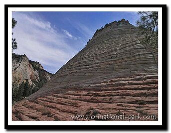
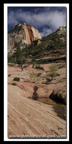
Utah Scenic Drives
|
||||||||||||||||
|
Byways Connect Southern Utah Attractions Grafton Ghost Town |
Connecting the National Parks with beauty and adventure Utah State Road 9 - thru Zion Park Utah State Road 14 is Cedar Mountain. Utah State Road 148 - to Cedar Breaks Arizona 89A and SR-67 to Grand Canyon |
Mt. Carmel Scenic Byway - The Mt. Carmel Scenic Byway runs 60 miles from Mt. Carmel Jct., the junction of SR-9 and US-89 to Scenic Byway 12. This beautiful road runs along the golf course at Mt. Carmel Jct., the White Cliffs of the Grand Staircase and then by historic towns, lakes, streams and even some hoodoos before meeting with SR-12.
 SR-12 - "Journey Through Time Byway"
Scenic Byway 12, an “All  American Highway” is 123 miles long, starting at US-89, south of Panguitch at the intersection with US-89, then passes through the unique scenery of Dixie National Forest's Red Canyon, Bryce Canyon National Park and ends in Torry, 5 miles west of Capital Reef National Park. This is a sparsely populated area of Utah with large sections of public lands. In 1985 the road was paved over Boulder Mountain bringing media attention and with that a multitude of visitors to travel the road from park to park. This long highway passes through lands of stark difference, from the hoodoos of Red Canyon and Bryce Canyon to the round domes of Capital Reef National Park. It is often referred to as the "journey through time" because all the evidence of ancient life found along the 123-mile path.
Directions to Zion National ParkFrom the North: Travel I-15 south, past Beaver. exit on Hwy 20. Follow US-89 to Mount Carmel Junction. Take SR-9 to Zion's east entrance.
|
|
|||
|
|
||||


Cedar Breaks - Cedar Mountain Scenic Drives
Markagunt High Plateau Scenic Byway, SR-14, is a 40 mile scenic byway. Beginning at Cedar City and going over Cedar Mountain through Dixie National Forest to the junction of SR-14 and US-89 at what the locals call "Todd's Junction" or "Long Valley Junction." Todd has sold his mini-mart gas station located at the intersection, but the name still remains. Locals call the area from the junction of US-89 and SR-14 to the junction of US-89 and SR-9 in Mt. Carmel Jct., Long Valley. The high school in the small town of Orderville is called Valley and the kids from all the small towns along that stretch of road go to Valley - thus the name "Long Valley." Markagunt is a Native American name for “highland of trees,” and trees are abundant along the drive over Cedar Mountain as well as lakes, streams, hoodoos, lava rock and everything else you dream a forest should be. The mountain road peaks at around 11,000 feet not too far from Navajo Lake.
Cedar Breaks Scenic Byway is the 6-mile Cedar Breaks road that begins at the intersection of SR-14 and SR-143 then runs from one end of the magnificent monument of red rock hoodoos to the other with several scenic pull-outs where you can look down into the great amphitheater of Cedar Breaks. Beyond Cedar Breaks is Brianhead Ski Resort.
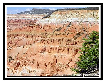 Photo: The drive along Cedar Breaks National Monument is unlike anything most have ever seen.
Scenic Drive from Southern Utah
to Grand Canyon's North Rim
Fredonia-Vermillion Cliffs Scenic Road
This is an 82-mile road from US 89A in Fredonia to the junction with US 89 south of Page, Arizona. Just a few miles south of Kanab, along this road, is the only place you can see of all the stair steps of the Grand Staircase. The Staircase begins at the North Rim of the Grand Canyon and spreads to the top riser; the hoodoos of Bryce Canyon in southern Utah. Only a portion of the 2-million acre Grand Staircase-Escalate National Monument is in this section of geologic land called the Grand Staircase.
Fredonia-Vermillion Cliffs Scenic Road runs between Fredonia, past the turn-off to Jacob Lake and continues 55-miles to Bitter Springs. You will turn at Jacob Lake to get to the North Rim of the Grand Canyon. Don't expect to see a lake there however, it's more of a pond and it's privately owned. I can only assume that "Jacob" owns the pond. At Jacob's Lake there is a wonderful Kaibab Forest Service Visitor Center where you can get information on the Kaibab Forest and North Rim trails, roads. There are some fantastic hikes and viewpoints in the Kaibab Forest that overlook or hike into the North Rim of the Grand Canyon.
Arizona State Route 67 is a 42-mile dead end path from Jacob’s Lake to the North Rim of the Grand Canyon. Designated as a scenic byway and dubbed the Kaibab Plateau-North Rim Parkway. The road does extend into the park itself, ending at the historic Grand Canyon Visitor Center. Like the other byways connecting southern Utah’s parks and monument to the North Rim, this road is gorgeous. As elevation increases, expect to see ponderosa pines, Engelmann spruce and sub-alpine fir along the way. Most winters after Thanksgiving, this road does close until about Mother's Day in May the next year, but once in a while ADOT does surprise us and announce they are keeping the road open year-round.
|
|
Zion National Park, Utah
History of the Thunderbird

East Zion Lodge
Vacation House
Group Lodging
East Zion Golf
East Zion RV Park
Vacation Packages
Mileage from
Mt. Carmel Jct.
Zion National Park 12
Bryce Canyon 60
Grand Canyon 85
Cedar Breaks 45
Grand Staircase 9
Dixie Forest 22
Sand Dunes 11
Coyote Butte 57
Red Canyon 47
Tuweep 90
Stay in a hotel the heart of the parks, Mount Carmel Junction, and visit the treasures of the Southwest and Utah.
Site Map
Site Map II
Site Map III
Zion Hiking
Zion Park Hiking
Zion Hiking Advanced
Zion Canyoneering
Kolob Hiking
Greater Zion Area
|
Zion History |
|---|
All rights reserved © Copyright Zion National-Park.com
Do not use text, photos or maps without permission from Zion National-Park.com