|
|
 |
|||
|
Red Canyon Cedar Mountain Bryce Canyon Bikes 4WD Horses Hike Vacation SR 12 Map Weather |
||||

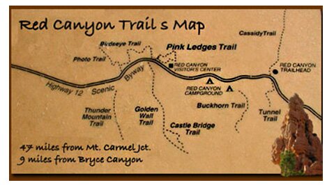
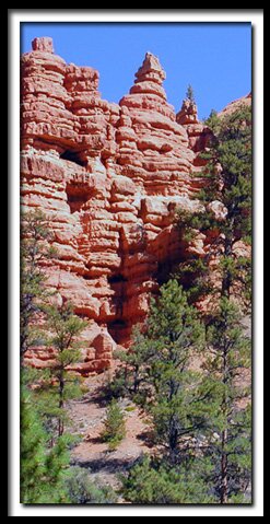
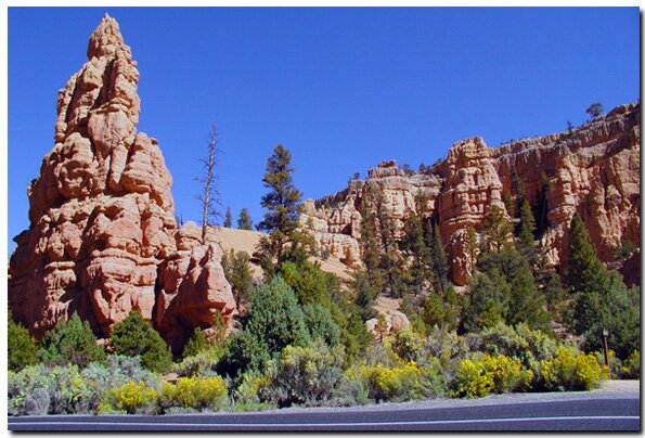
Horse Trails: Red Canyon RecreationOn the way to Bryce Canyon be sure to stop and enjoy Red Canyon in Dixie National Forest. It's not unusual for the visitor driving Scenic Byway 12, to think they have arrived in Bryce Canyon, as they view the red rock hoodoos towering around them.The Red Canyon recreation area allows ATV use, 4WD vehicles, cross country skiing, horseback riding and even dogs on select trails. If looking for a user friendly area to relax, camp and enjoy, then look no further than Southern Utah's Red Canyon or Cedar Mountain, both part of Dixie National Forest. Casto Canyon Trail - This 5.5 mile moderate to strenuous trail is open to horses. There are great views of the red rocks along this hike. Losee Canyon Trail - This 2.9 mile moderate trail is open to horses. The trailhead is at the bottom of Losee Canyon. This trail connects with the Cassidy trail. Ledge Point Trail - This .6 mile easy trail is open to horses and ends at an overlook of Red Canyon. Rich Trail - This 2.1 mile moderate to strenuous trail is open to horses. This trail connects with the Cassidy Trail. Cassidy Trail - This 8.9 mile strenuous trail is open to horses. The trail is named for the infamous Butch Cassidy who used sections of the trail. Thunder Mountain Trail - This 7.8 mile moderate to strenuous trail is open to horses. The red rocks on the lower section of the trail are outstanding. Barney Cove Trail - This 1.9 mile moderate trail is open to horses. |
|||||||||||||


|
Utah's Dixie National Forest: Red Canyon 
|
|
|||
|
|
||||

|
|
Dixie National Forest, Utah
Red Canyon on Scenic Byway 12

East Zion Lodge
Vacation House
Group Lodging
East Zion Golf
East Zion RV Park
Vacation Packages
Family Reunion
Bus Tours
Business Retreat
Mileage from
Mt. Carmel Jct.
Zion National Park 12
Bryce Canyon 60
Grand Canyon 85
Cedar Breaks 45
Grand Staircase 9
Dixie Forest 22
Sand Dunes 11
Coyote Butte 57
Red Canyon 47
Tuweep 90
Stay in the heart of the parks, Mount Carmel Junction, and visit the treasures of the Southwest and Utah.
"I don't know who Mary Cisneros is, but I mean zionnational-park.com
It's a better site than the NPS's anyway."
Written by the authors of the book: Favorite Hikes in and around Zion National Park
Contact Mary to report errors:
|
Zion History |
|---|
All rights reserved © Copyright Zion National-Park dot com
Do not use text, photos or maps without permission © Zion National-Park dot com
Contact the Author Mary Cisneros