|
|
 |
|||
|
Red Canyon Cedar Mountain Bryce Canyon Bikes 4WD Horses Hike Vacation SR 12 Map Weather |
||||

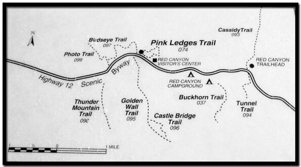
Hiking-only Trails in Red CanyonThere are some fun hikes in Red Canyon, including the well known Thunder Mountain Trail. Like Bryce Canyon, Red Canyon is open year-round. Unlike Bryce Canyon, the trails of Red Canyon start on the canyon floor rather than at the rim.
Birdseye Trail - The Birdseye Trail is a moderate .75 mile trail that takes hikers up close to red rock formations. The trail is named for the "bird shaped head" overlooking the area. Begin this trail at the visitor center. This trail can be followed to the Photo Trail. Pink Ledges Trail - This is an easy to moderate 1 mile trail starting at the Red Canyon Visitors Center. This hike shows off some of the more outstanding formations in Red Canyon. Begin the trail behind the visitor center and follow the path to a junction. One path will lead back to the parking lot, but a longer path will lead to ambush rock, an area of exceptional rock formations. Buckhorn Trail - This .9 mile moderate to strenuous hike begins at the Red Canyon Campground, site #23. The trail switchbacks as it climbs. The trail leads high above the canyon, offering great views . This is one of the hikes that is a must do in Red Canyon. Tunnel Trail - This .7 mile moderate trail begins west of the highway tunnel. The path leads through a wash and into a forested section of the Red Canyon recreation area, ascending 300' along a ridge. This hike is a good one for kids, offering a round trip that is less than 2 miles with great views along the way. Golden Wall Trail - This 2.8 mile moderate to strenuous trail has an uphill climb. It begins on Scenic Byway 12, west of the visitor center and connects to the Buckhorn Trail. The panoramic view at the trails end is worth the climb. This trail connects to the Castle Bridge Trail. Castle Bridge Trail - This .65 mile moderate hike offers great scenery of eroded rock formations, called hoodoos, and the beautiful canyons. Sadly, the balanced rock on this trail has fallen. Trails open to Hiking, Horses and Off-Road Vehicles or BikesCasto Canyon Trail - This 5.5 mile moderate to strenuous trail is open to hiking, horseback and off-road vehicles. Distance: 5.5 miles. There are great views of the red rocks along this hike. Losee Canyon Trail - This 2.9 mile moderate trail is open for hiking, bikes and horses. The trailhead is at the bottom of Losee Canyon. This trail connects with the Cassidy trail. Ledge Point Trail - This .6 mile easy trail ends at an overlook of Red Canyon. Rich Trail - This 2.1 mile moderate to strenuous trail connects with the Cassidy Trail. Cassidy Trail - This 8.9 mile strenuous trail is named for the infamous Butch Cassidy who used sections of the trail. Thunder Mountain Trail - This is a 7.8 mile moderate to strenuous trail. The red rocks on the lower section of the trail are outstanding. Barney Cove Trail - This is a 1.9 mile moderate trail. This trail is used primarily as a connector trail between Casto Canyon and the Fremont ATV trails. |
|||||||||||||


|
Utah's Dixie National Forest: Red Canyon 
|

|
|||
|
|
||||

|
|
Dixie National Forest, Utah
Red Canyon on Scenic Byway 12

East Zion Lodge
Vacation House
Group Lodging
East Zion Golf
East Zion RV Park
Vacation Packages
Family Reunion
Bus Tours
Business Retreat
Mileage from
Mt. Carmel Jct.
Zion National Park 12
Bryce Canyon 60
Grand Canyon 85
Cedar Breaks 45
Grand Staircase 9
Dixie Forest 22
Sand Dunes 11
Coyote Butte 57
Red Canyon 47
Tuweep 90
Stay in the heart of the parks, Mount Carmel Junction, and visit the treasures of the Southwest and Utah.
"I don't know who Mary Cisneros is, but I mean zionnational-park.com
It's a better site than the NPS's anyway."
Written by the authors of the book: Favorite Hikes in and around Zion National Park
Contact Mary to report errors:
|
Zion History |
|---|
All rights reserved © Copyright Zion National-Park dot com
Do not use text, photos or maps without permission © Zion National-Park dot com
Contact the Author Mary Cisneros