Please respect outdoor Rock Art museums the same way that you would an indoor museum.
South Fork Indian Canyon Trail to Pictographs
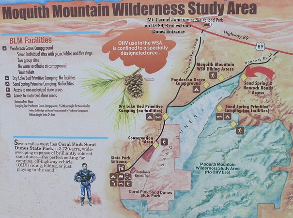
Moquith Mountain is found off US-89 near the Coral Pink Sand Dunes State Park. The area is a haven of sand dunes, slickrock plateaus, vermilion cliffs, drainages, beautiful canyons and hidden treasures such as the South Fork Indian Pictographs.
Photo Album:
South Fork Indian Canyon pictures Map:Moquith Mountain MapTopo Map Day hike: Yes Distance: 1 mile/1.6 km round trip Average hiking time: 30 minutes Equipment: Map - USGS 7.5' Topo 'Yellow Jacket Canyon' Quad Difficulty: Easy Permits: No Trail conditions: Good path, fenced in steep areas. Trailhead: At the end of the South Fork Indian Canyon Road off the Sand Spring Road Trailend: Same as starting Trail Access: 4WD, sandy road Elevation Change: 150' Off the Beaten Path: Yes Best season: Year-round Water availability: No Restrooms: Located at the Sand Dunes State Park Visitor Center and Campground.
South Fork Indian Canyon Pictographs - The South Fork Indian Canyon Pictographs are located within the Moquith Mountain Wilderness Study Area.
Hancock Road - From Mount Carmel Junction, drive south on Highway 89. Take the Sand Dune Road (Yellow Jacket Road) toward the Coral Pink Sand Dune State Park. Travel 8.3 miles from Highway 89 and look for the "T" in the road. Turn left at the "T" onto Hancock Road. Drive 3.5 miles, passing the Ponderosa Campground, to the intersection of Hancock Road and the 4WD Sand Spring Road on the right. A 4WD vehicle allows travel within .5 mile of the pictographs. If your vehicle will not make it on the soft sandy roads, walk from the "T" in Hancock Road and Sand Dune Spring Road. It is 4 miles, one way, to the pictographs.
If traveling from Kanab, take Hancock Road to Coral Pink Sand Dunes, and travel almost 6 miles from Highway 89 to the intersection of Hancock Road and the 4WD Sand Spring Road, on the left. If traveling from Coral Pink Sand Dunes State Park Visitor Center and Campground, travel North East 3.3 miles to the intersection of Sand Dune Road and Hancock Road, turn right on Hancock Road and travel 3.5 miles, passing the Ponderosa Campground, to the intersection of Hancock Road and the 4WD Sand Spring Road on the right.
Sand Spring 4WD Road - Travel southwest on Sand Spring 4WD Road passing Sand Spring after 1 mile, continue southwest for another 1.5 miles and look for the left hand turn to South Fork Indian Canyon. The road becomes narrow and curvy for the next 1.75 miles. The road ends on the point of a ridge with ample parking.
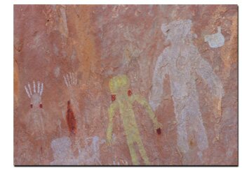
South Fork Indian Canyon Pictographs - From the parking area, walk northeast to locate a path of use through the sand. Continue the gradual descent down the obvious trail. The trail soon becomes obvious as it continues east and then switches direction after a small drop down through the rocks. Continue descending and then traversing the hillside beneath the cliff band on hikers left. Shortly you will arrive at the (chain-link fence protected) South Fork Indian Canyon Pictographs. The distance from the parking lot to the pictographs is about .5 mile and the descent is about 150'. Be sure to bring a camera with a good zoom lens and wide angle lens. The pictographs sit at the back of a large alcove and pictures must be taken from behind the fence 30' away.
Best Trail Features - South Fork Indian Canyon is home to the heads of two unnamed canyons and outstanding scenery along the trail. The wall of pictographs is outstanding. The pictographs are dated at about 1200 A.D.
Petroglyphs and Pictographs - There are two basic types of ancient rock art - petroglyphs and pictographs. Petroglyphs were carved into rock, often in soft sandstone like the rock in South Fork Indian Canyon. Pictographs were painted using natural pigments. Those are found on this hike. Due to the delicate nature of ancient paintings, they are usually only found in caves or other areas where they have been protected from the elements.
Directions to the Coral Pink Sand Dunes State Park Plan your Coral Pink Sand Dunes Vacation with our
Utah Maps and Information
Coral Pink Sand Dunes from Zion National Park
From Zion National Park. Exit Zion Park through the east entrance and drive 12 miles to the junction U-9 & US-89. This is Mount Carmel Junction. Turn south on US-89. Turn-off to the sand dunes 3 miles from Mt. Carmel Junction. Follow Yellow Jacket road for 8 miles to the Coral Pink Sand Dunes State Park. Lodging for Coral Pink Sand Dunes
Coral Pink Sand Dunes from
Utah Highway 59 & Arizona 389
From Hurricane, Utah take Utah 59 to Arizona 389 just past Colorado City look for the road leading to the Coral Pink Sand Dunes. It will come out 3 miles from Mt. Carmel Junction, Utah. Do not travel through the dunes when it's been raining or the roads are wet from snow.
Coral Pink Sand Dunes through Fredonia, Arizona
From Hurricane, Utah take Utah 59 to Arizona 389 and travel to Fredonia, Arizona, then to Kanab, Utah. Drive on US Highway toward Mt. Carmel Junction, turning at the signed entranced to the Coral Pink Sand Dunes.
Southfork Canyon Indian Pictographs
Lodging and services are available on the gorgeous east side of Zion National Park, where guests are close to Zion National Park (12 miles), Bryce Canyon National Park (60 miles), Cedar Breaks National Monument (45 miles), Coral Pink Sand Dunes (12 miles), and the North Rim of the Grand Canyon (85 miles). It's where city traffic is absent and the skies are bright and clean.
GPS Coordinates WGS84 Datum
Intersection of Hancock Road and Sand Spring Road
37°05.8441 N
112°38.7257 W
Intersection of Sand Spring Road (4WD)
and South Fork Indian Canyon Pictograph Road (4WD)
37°03.4926 N
112°40.6890 W
South Fork Indian Canyon Pictographs
37°04.0104 N
112°39.0081 W
Mileage from
Mt. Carmel Jct.
Zion National Park 12
Bryce Canyon 60
Grand Canyon 85
Cedar Breaks 45
Grand Staircase 9
Dixie Forest 22
Sand Dunes 11
Coyote Butte 57
Red Canyon 47
Tuweep 90
Stay in the heart of the parks, Mount Carmel Junction, and visit the treasures of the Southwest and Utah.
This is my new favorite quote:
"I don't know who Mary Cisneros is, but I mean zionnational-park.com
It's a better site than the NPS's anyway."
Written by the authors of the book: Favorite Hikes in and around Zion National Park


 Moquith Mountain
 Best Trail Features - South Fork Indian Canyon is home to the heads of two unnamed canyons and outstanding scenery along the trail. The wall of pictographs is outstanding. The pictographs are dated at about 1200 A.D.
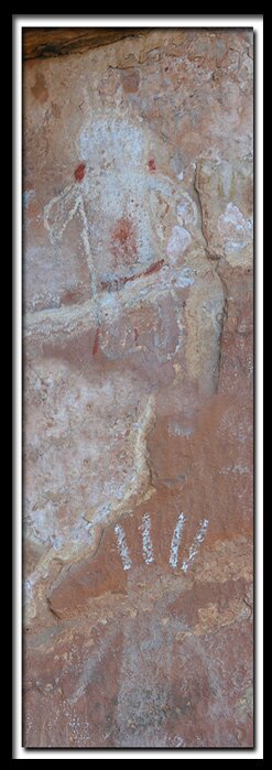


 GPS Coordinates WGS84 Datum