 |
||||
|
Zion National Park Lodging Park Info Vacation Weather Photos Hike SR-9 Slots Backpack Camping |
||||
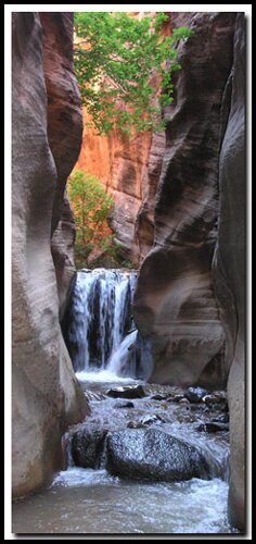
Kanarra CreekKanarra Creek is great for those visiting Southern Utah in quest of a perfect multi-hued, twisting and turning slot canyon to photograph. Those without the time, skills or equipment to descend the more technical (advanced) slivers carved by wind, water and time, Kanarra Creek is the right destination. Access to Kanarra Creek, makes this hike the perfect stop for the amateur looking for professional photo opportunities. There are two obstacles within the narrows that may thwart travel upstream to those less willing navigate obstacles, but just arriving at the first obstacle will yield the recreation st and photographer plenty of eye candy and memories that won't soon be forgotten. Hikers begin in the town of Kanarraville, which makes the approach relatively short, but be ready for some uphill hiking. Since it's outside the Zion National Park boundaries, it is not protection , however a recently installed gate prevents motorized vehicles from driving all the way into the canyon . Please be respectful and don't leave behind garbage, and pack out any trash that you may find . The travel up the creek is done in and out of a pristine gentle flowing creek bed, so be prepared with shoes that are sticky and rugged, and also be sure to have warm clothing for the shaded and cool travel in the narrows.
 Kanarra Creek Trailhead Kanarra Creek Trailhead
To locate the creek bed trail, exit I-15 at exit 51, 5.5 miles south of Cedar City and travel south on old Highway 91 for another 4.5 miles to the sleepy little community of Kanarraville. If traveling from the south, drive 33 miles north on I-15 from St. George and take exit 40 at Kolob Canyons then drive north on old Highway 91 to arrive at Kanarraville. In Kanarraville locate 100 North and turn east toward the water tank just above the town. Drive through two stop signs and the road turns to dirt and gravel. Park off the road at the gate. The hike begins here by passing through the hikers gate. Follow the road towards the water tank on the hillside. At the water tank the road now descends and enters Kanarra Creek Canyon. At the bottom of the hill the road will cross the flowing creek, and travels above the creek bed on the north side for another .4 miles before ending.
Once again travel upstream is wonderful as the glowing light is reflected on canyon walls. Shortly hikers are greeted with the second obstacle, another 10' waterfall. This time another ladder may be present however never a surety! The ladder upon writing of this description was a rope ladder with 2x4 wooden rungs and then a somewhat sketchy rope handle traverse along the right side wall to achieve the waterfall top. Beyond the top of the second waterfall the narrows are short lived as the walls widen and allow deciduous growth on the banks of the creek which is reminiscent of travel below the narrows. Walk up Kanarra Creek another half-mile past the last waterfall obstacle. This area has several flat areas above the creek that are nice for a picnic or rest area. Soon another drainage (slot canyon) enters from the left side. Beyond this confluence travel becomes more vegetated and difficult and is not recommended. Total walking distance to this point is 2.2 miles. Returning back downstream often provides the best photos as the sunlight filtering through the fluted canyon seems to create translucence in the rock. There has been, off and on, a designated parking area that cost $10 to park or you can park elsewhere and walk in. There has also, off and on, been an entrance fee. They have also been closing the area at 7:00 PM in the summer and have placed porta-potties and trash cans in various locations along the trail to the creek to help keep the place clean. There is no telling what will be there when you arrive, due to the fluctuations. Take care of this area or loose it! July 2008 - Even more recent problems:
Parking Narrows Begin Trail End Beta: Coordinates and other trail and canyoneering information by Zion Park search and rescue veteran team member Bo Beck and zionnational-park.com author Mary Cisneros.
Suggested Gear: A sturdy pair of shoes are recommend to hike the trails in Zion National Park. Many quality shoes will help grip the rocks and prevent injury.
Zion National Park, UtahHistory of the Thunderbird |
East Zion Lodge Mileage from Stay in a hotel the heart of the parks, Mount Carmel Junction, and visit the treasures of the Southwest and Utah. Site Map Zion Hiking |
||||||||||||
|
This is my new favorite quote:
"I don't know who Mary Cisneros is, but I mean zionnational-park.com It's a better site than the NPS's anyway." Written by the authors of the book: Favorite Hikes in and around Zion National Park |
|||||||||||||
|
Zion History |
|---|
All rights reserved © Copyright Zion National-Park dot com
Do not use text, photos or maps without permission © Zion National-Park dot com
Contact the Author Mary Cisneros with any errors


 GPS Coordinates WGS84 Datum