|
|
 |
|||
|
Bryce Canyon Lodge & Camp Bryce Info Vacation Photos Hike Backpack Map SR-12 Area weather |
||||

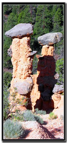
Hat Shop TrailThe name of this small Southwestern Utah park is deceptive, Bryce Canyon is not really a canyon at all, rather it is a series of breaks in fourteen enormous amphitheaters plummeting down one-thousand feet, spanning twenty-five miles and encompassing thirty-six thousand acres. Tall, misshapen limestone formations crowd together to form magnificent castle-like scenes, dominating the uncommon views of the eastern edge of the Paunsaugunt Plateau. According to Paiute myth, people long ago angered the coyote so he turned them all to rock. When you visit, think of this tale while peering down into the amphitheaters and imagine them standing proud and tall. These bizarre sedimentary rocks are usually referred to as hoodoos. While most are similar in appearance, the Hat Shop hoodoos have a peculiar personality all their own. These odd creations appear as though a child has been playing in a limestone filled sandbox. Perhaps you can envision the child scooping up the limestone mixture, letting it drip down to form a cone shaped structure and then placing a rock on top to protect his creation. These types of hoodoos are not common in the park, but there is one hike, the Hat Shop Trail, that leads to a small cluster of them.
Begin at Bryce Point, located 2 miles south of the visitor center near the park entrance. Turn left at the sign for Inspiration and Bryce Point then follow the road to the parking area. Walk up toward the rim to locate the sign indicating the Bryce Point Trailhead, a popular place for squirrels and chipmunks as well as humans. This eastern edge of the park offers one of the most scenic views from the rim and is a favorite spot for early risers to watch the sun rise and touch upon the jagged pink stone of the vast amphitheater below. The trail is the first part of the 23 mile Under the Rim Trail as well as the Hat Shop Trail. The path descends below the rim, winding through Douglas fir, ponderosa and limber pines and past traditional hoodoos. You will come to a junction with the Peek-a-boo Trail, where the path will then head south, descending farther into the bowl. There is no interpretive sign or marker indicating the end, but once you see the balanced rock columns on the right, where the trail begins to level out atop a ridge, you will know you are there. Although the dolomite toppers appear to be part of the original columns, they are not, but instead fell from cliffs above, creating an umbrella of sorts that serves to protect the softer rock below. Stay away from edges and do not attempt to go down where the top heavy hoodoos are perched. At this point, return the same way you came. The hike out is steep and in full sun, so if you are doing this in the summer, it is wise to begin early in the day.
Bryce Canyon National Park, Utah |
East Zion Lodge Mileage from Stay in the heart of the parks, Mount Carmel Junction, and visit the treasures of the Southwest and Utah. Site Map Bryce Canyon History
|
||||||||||||
|
This is my new favorite quote:
"I don't know who Mary Cisneros is, but I mean zionnational-park.com It's a better site than the NPS's anyway." Written by the authors of the book: Favorite Hikes in and around Zion National Park Contact Mary to report errors: |
|||||||||||||


|
Zion History |
|---|
All rights reserved © Copyright Zion National-Park dot com
Do not use text, photos or maps without permission © Zion National-Park dot com
Contact the Author Mary Cisneros