This trail is near the North Rim of the Grand Canyon and the Kaibab Forest in the Kanab Wilderness Area.
A step back into history surrounds hikers with an amazing array of writings, etchings and structures left behind by ancient Native American inhabitants who once thrived in this canyon tributary of Kanab Creek. The paintings and other remnants date back as far as 500 BC, yet are amazingly well preserved considering the relatively exposed location, not just to the elements of weather, but also to modern human interference. At one time prior to the canyons wilderness designation there was a road that accessed Snake Gulch, but now only hikers and equestrians frequent this spiritual experience. Other than cattle grazing, nothing indicates this areas frequent use except the path alongside the wash. It's obvious that wilderness designation has helped keep Snake Gulch from the desecration that affects other less controlled archaeological sites. Hundreds of pictographs, some petroglyphs and several ruins and granaries are found along the low walls on this 20 mile round trip. Hiking is very easy with the lack of any significant elevation gain or loss. It is imperative that travel is maintained on existing trails. Some of the trails are faint to the sites, but creating new trails to panels and remnants will only speed up the destruction of the fragile cliff bands that are home to these sacred artworks. Do not leave behind any evidence by leaving trash or footprints. Do not touch any of the structures or paintings as the oils from human skin will only speed up the erosion and destruction of these primitive landmarks. Also do not make a fire in this area since smoke does damage them.
Snake Gulch at a Glance Photos:Snake Gulch Photos Map:Snake Gulch Map Day Hike: Yes Trail Distance: 19 miles round trip or as far as you want to go. There is no scenic destination. Average Hiking Time: 10 hours, but this is moving quite fast to do the entire hike. It was not a casual stroll. Trail Usage: Low Difficulty: This is a relatively easy hike, lacking significant elevation change, but it is long. Trail Conditions: When it's dry and hot there is little reprieve from the sun. Trailhead: Snake Gulch - Can enter the area from either Fredonia or Jacob Lake. Trailend: Same as trailhead Best Season: Spring or Fall. This trail is in full sun and it is often too hot in the summer to hike. In the winter it might be difficult to drive to the trailhead due to snow. Off the Beaten Path: Yes
Trailhead - To get to the Snake Gulch Trailhead drive one-mile south of Fredonia, Arizona on Highway 89A. Look for FS 22 on the right side near a building and turn right on the paved road. Follow the mostly paved road for 21 miles where another road comes in on the left. Continue on the now dirt road FS 22 for another 1.5 miles and locate FS 423 on the right, then turn right. Follow 423 for 1.3 miles and turn right onto FS 642 and follow this road for 2.6 miles to the parking lot and trailhead for Snake Gulch. Be sure to register at the trailhead.
Route - Begin hiking on the well used trail to the north and soon the path will turn west, opening up the view of what the remainder of the route will be. We recommend getting an early start and pushing hard until you have reached the end of either our route description or to where you feel you can make it back to your vehicle safely before dark. The lighting in the morning is not as conducive to nice photography, but if you wait too long it will be getting dark on you on your hike back.
A half-mile into the trail you will pass a gate. After a couple of miles pictographs visible along the path will lure you for picture taking. If the 9.5 miles to Wildband Spring can be completed in 3-4 hours, then on the return trip the sun should be ideal for capturing the pictographs for photography on the northern wall. Keep in mind that the pictographs and petroglyphs are the target for this hike and by no means do you need to do a 20 mile round trip.
The section between Table Rock Spring and Pigeon Canyon yields very few archaeological remnants, however downstream, just past Pigeon Canyon on the north side there are two alcoves, up high, that you will find of interest. Tread lightly there as pottery chards, corn cobs and chips lay amongst the battled ruin walls. Unless it gets moved there should be a galvanized tub full of water at Wildband Spring .
Directions to North Rim Grand Canyon: From Zion National Park, take on U-9 through the park to Mt. Carmel Jct. Turn south on US-89 to Kanab. There is only one stop light in Kanab; this is where US-89 changes to ALT 89. Fredonia, Arizona is 6 miles. In Fredonia take 89A to Jacob lake (36 miles), then take AZ 67 to the Grand Canyon North Rim park entrance.
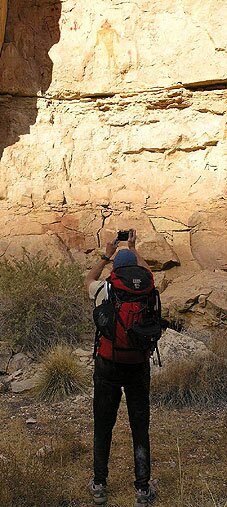
Bo Beck stop to take a photograph of some of the Snake Gulch Pictographs.
Lodging and services are available on the gorgeous east side of Zion National Park, where guests are close to Zion National Park (12 miles), Bryce Canyon National Park (60 miles), Cedar Breaks National Monument (45 miles), Coral Pink Sand Dunes (12 miles), and the North Rim of the Grand Canyon (85 miles). It's where city traffic is absent and the skies are bright and clean.
On our quick 20 mile jaunt, we found most of the granaries and pictographs on the north side of Snake Gulch to the east of Table Rock. There are also several panels on the south side of the wash. A large panel of petroglyphs and a few pictographs was found several miles east of table rock. There is a panel beneath an alcove that was quite different from the rest, having several petroglyphs, and should be one of the first you spot on your hike in or last on your hike out.
GPS Coordinates WGS84 Datum
89A and FS 22 "turn-off"
36 56.083 N
112 30.327 W
FS 22 and FS 423 "turn right"
36 40.089 N
112 20.839 W
Trailhead
36 42.348 N
112 22.639 W
Hiker and Equestrian Gate
36 42.661 N
112 22.667 W
Petroglyph Alcove
36 42.623 N
112 24.425 W
Table Rock Spring
36 42.771 N
112 28.031 W
Ruin
36 43.190 N
112 30.792 W
Wildband Spring and Trailend
36 43.030 N
112 30.717 W
Mileage from
Mt. Carmel Jct.
Zion National Park 12
Bryce Canyon 60
Grand Canyon 85
Cedar Breaks 45
Grand Staircase 9
Dixie Forest 22
Sand Dunes 11
Coyote Butte 57
Red Canyon 47
Tuweep 90
Stay in the heart of the parks, Mount Carmel Junction, and visit the treasures of the Southwest and Utah.
This is my new favorite quote:
"I don't know who Mary Cisneros is, but I mean zionnational-park.com
It's a better site than the NPS's anyway."
Written by the authors of the book: Favorite Hikes in and around Zion National Park
Contact Mary to report errors:


 Trailhead - To get to the Snake Gulch Trailhead drive one-mile south of Fredonia, Arizona on Highway 89A. Look for FS 22 on the right side near a building and turn right on the paved road. Follow the mostly paved road for 21 miles where another road comes in on the left. Continue on the now dirt road FS 22 for another 1.5 miles and locate FS 423 on the right, then turn right. Follow 423 for 1.3 miles and turn right onto FS 642 and follow this road for 2.6 miles to the parking lot and trailhead for Snake Gulch. Be sure to register at the trailhead.